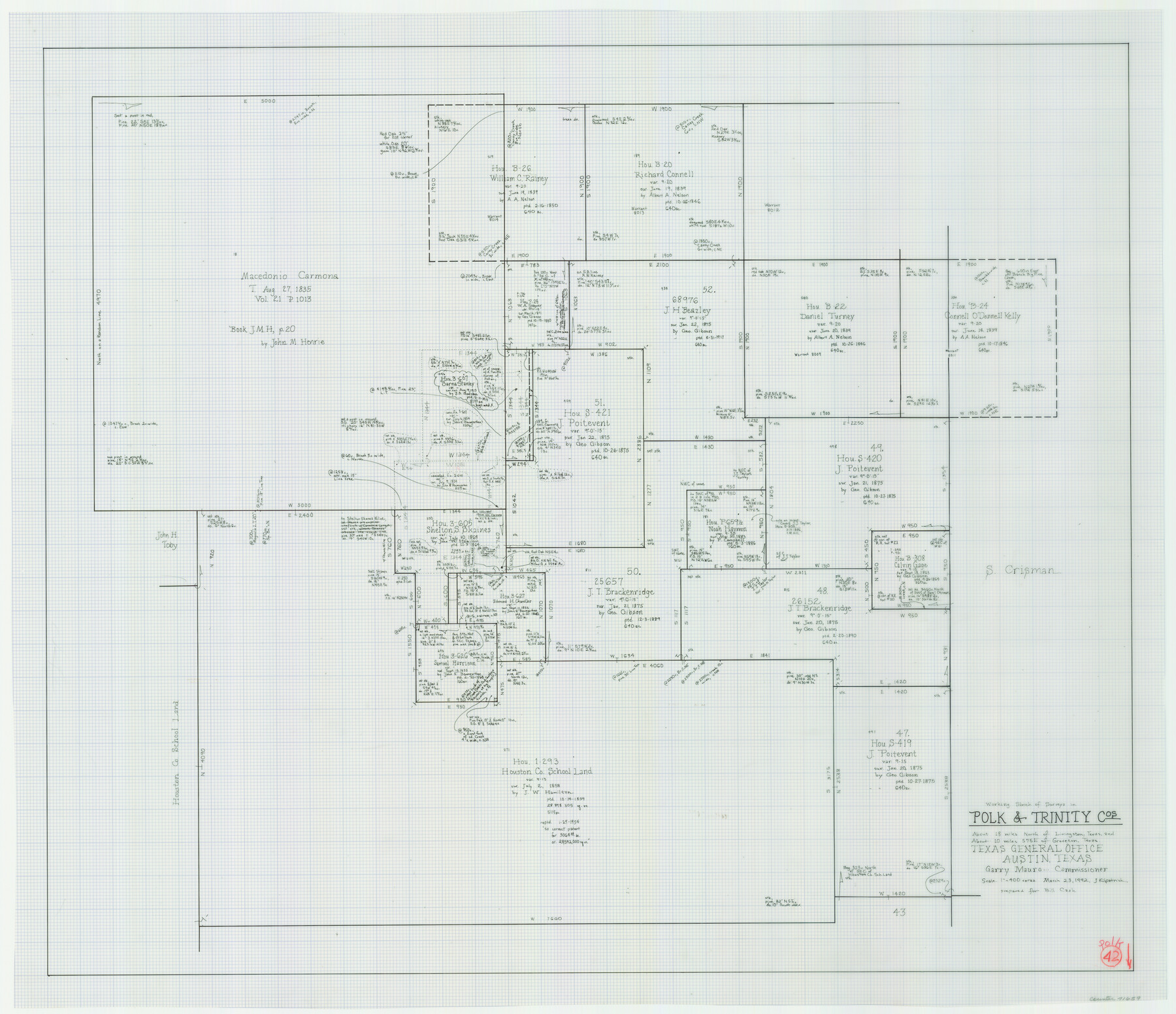
Polk County Working Sketch 42
-
Map/Doc
71659
-
Collection
General Map Collection
-
Object Dates
3/23/1992 (Creation Date)
-
People and Organizations
Joan Kilpatrick (Draftsman)
-
Counties
Polk Trinity
-
Subjects
Surveying Working Sketch
-
Height x Width
30.8 x 35.7 inches
78.2 x 90.7 cm
-
Scale
1" = 400 varas
Part of: General Map Collection
Topographical Map of the Rio Grande, Sheet No. 10

Print $20.00
- Digital $50.00
Topographical Map of the Rio Grande, Sheet No. 10
1912
Map/Doc 89534
Taylor County Sketch File 10

Print $20.00
- Digital $50.00
Taylor County Sketch File 10
Size 35.2 x 34.4 inches
Map/Doc 10383
Jeff Davis County Working Sketch 12

Print $20.00
- Digital $50.00
Jeff Davis County Working Sketch 12
1948
Size 21.5 x 29.0 inches
Map/Doc 66507
Sterling County Rolled Sketch 11

Print $20.00
- Digital $50.00
Sterling County Rolled Sketch 11
1884
Size 22.5 x 46.6 inches
Map/Doc 9945
[Corpus Christi & Rio Grande Certificates]
![64492, [Corpus Christi & Rio Grande Certificates], General Map Collection](https://historictexasmaps.com/wmedia_w700/pdf_converted_jpg/qi_pdf_thumbnail_19225.jpg)
Print $16.00
- Digital $50.00
[Corpus Christi & Rio Grande Certificates]
1874
Size 14.3 x 8.7 inches
Map/Doc 64492
Zavala County Sketch File 26

Print $4.00
- Digital $50.00
Zavala County Sketch File 26
1886
Size 14.3 x 8.9 inches
Map/Doc 41390
Burnet County Working Sketch Graphic Index

Print $20.00
- Digital $50.00
Burnet County Working Sketch Graphic Index
1924
Size 46.5 x 41.2 inches
Map/Doc 76482
Parker County Working Sketch 9

Print $20.00
- Digital $50.00
Parker County Working Sketch 9
1958
Map/Doc 71459
Polk County Boundary File 70a

Print $40.00
- Digital $50.00
Polk County Boundary File 70a
Size 18.1 x 23.4 inches
Map/Doc 57935
Motley County Sketch File 6a (S)

Print $40.00
- Digital $50.00
Motley County Sketch File 6a (S)
1894
Size 14.3 x 14.4 inches
Map/Doc 32147
McCulloch County Working Sketch 14

Print $20.00
- Digital $50.00
McCulloch County Working Sketch 14
1990
Size 15.3 x 29.0 inches
Map/Doc 70689
Cottle County Working Sketch 21

Print $20.00
- Digital $50.00
Cottle County Working Sketch 21
1982
Size 37.0 x 46.6 inches
Map/Doc 68331
You may also like
Lampasas County Working Sketch 11

Print $20.00
- Digital $50.00
Lampasas County Working Sketch 11
1964
Size 38.3 x 42.8 inches
Map/Doc 70288
[Sketch for Mineral Applications 26885-6 - Reagan and Crockett Cos., W. H. Bland]
![3219, [Sketch for Mineral Applications 26885-6 - Reagan and Crockett Cos., W. H. Bland], General Map Collection](https://historictexasmaps.com/wmedia_w700/maps/3219-1.tif.jpg)
Print $20.00
- Digital $50.00
[Sketch for Mineral Applications 26885-6 - Reagan and Crockett Cos., W. H. Bland]
1932
Size 38.4 x 9.7 inches
Map/Doc 3219
Williamson County Sketch File 1

Print $4.00
- Digital $50.00
Williamson County Sketch File 1
1847
Size 8.8 x 10.1 inches
Map/Doc 40299
Classification of Blocks 1 to 58, Set Apart to University by Constitution of 1876 by M. B. Moore

Classification of Blocks 1 to 58, Set Apart to University by Constitution of 1876 by M. B. Moore
Map/Doc 81726
Aransas County Rolled Sketch 9

Print $40.00
- Digital $50.00
Aransas County Rolled Sketch 9
1955
Size 85.3 x 41.9 inches
Map/Doc 8409
The Chief Justice County of Red River. Undated

Print $20.00
The Chief Justice County of Red River. Undated
2020
Size 16.6 x 21.8 inches
Map/Doc 96065
Shelby County Sketch File 24

Print $36.00
- Digital $50.00
Shelby County Sketch File 24
1850
Size 13.0 x 8.1 inches
Map/Doc 36647
Brooks County Sketch File 6

Print $12.00
- Digital $50.00
Brooks County Sketch File 6
1941
Size 13.2 x 8.3 inches
Map/Doc 16560
Flight Mission No. CLL-3N, Frame 5, Willacy County

Print $20.00
- Digital $50.00
Flight Mission No. CLL-3N, Frame 5, Willacy County
1954
Size 18.4 x 22.1 inches
Map/Doc 87071
Contracted Boundaries and Timeline of Mexican Empresario Colonies in Texas

Contracted Boundaries and Timeline of Mexican Empresario Colonies in Texas
2025
Size 17.0 x 11.0 inches
Map/Doc 97439
Map of the United States Engraved to Illustrate Mitchell's School and Family Geography

Print $20.00
Map of the United States Engraved to Illustrate Mitchell's School and Family Geography
1839
Size 11.6 x 17.4 inches
Map/Doc 79734
General Highway Map, Hood County, Somervell County, Texas

Print $20.00
General Highway Map, Hood County, Somervell County, Texas
1940
Size 18.3 x 24.8 inches
Map/Doc 79131