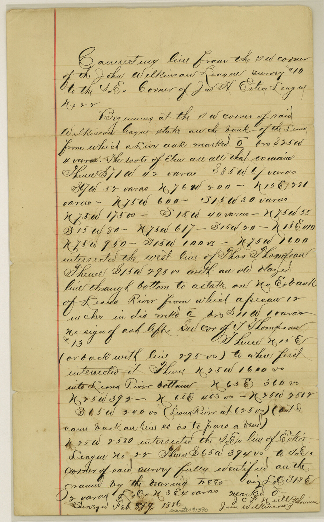
Zavala County Sketch File 26
[Connecting line from the southwest corner of the John Wilkinson league no. 10 to the southeast corner of Jno. H. Estice league no. 22]
-
Map/Doc
41390
-
Collection
General Map Collection
-
Object Dates
2/1886 (Creation Date)
2/8-9/1886 (Survey Date)
-
People and Organizations
J.C.F. Neill (Chainman/Field Personnel)
Jim Wilkinson (Chainman/Field Personnel)
George Myers (Surveyor/Engineer)
-
Counties
Zavala
-
Subjects
Surveying Sketch File
-
Height x Width
14.3 x 8.9 inches
36.3 x 22.6 cm
-
Medium
paper, manuscript
-
Features
Leona River
Part of: General Map Collection
Roberts County Working Sketch 39

Print $20.00
- Digital $50.00
Roberts County Working Sketch 39
1978
Size 26.6 x 22.7 inches
Map/Doc 63565
Colorado County Sketch File 17

Print $22.00
- Digital $50.00
Colorado County Sketch File 17
Size 8.7 x 7.7 inches
Map/Doc 18949
[Location, Fort Worth & Denver Railroad, through Wilbarger County]
![64344, [Location, Fort Worth & Denver Railroad, through Wilbarger County], General Map Collection](https://historictexasmaps.com/wmedia_w700/maps/64344.tif.jpg)
Print $40.00
- Digital $50.00
[Location, Fort Worth & Denver Railroad, through Wilbarger County]
Size 20.8 x 123.5 inches
Map/Doc 64344
McCulloch County Sketch File 3

Print $12.00
- Digital $50.00
McCulloch County Sketch File 3
1893
Size 11.1 x 8.5 inches
Map/Doc 31169
Denton County Sketch File 36a

Print $6.00
- Digital $50.00
Denton County Sketch File 36a
1898
Size 11.3 x 9.1 inches
Map/Doc 20773
Archer County Working Sketch 15

Print $20.00
- Digital $50.00
Archer County Working Sketch 15
1948
Size 20.7 x 31.9 inches
Map/Doc 67156
Duval County Working Sketch 50

Print $20.00
- Digital $50.00
Duval County Working Sketch 50
1984
Size 38.0 x 32.0 inches
Map/Doc 68774
Brazoria County Working Sketch 49a

Print $20.00
- Digital $50.00
Brazoria County Working Sketch 49a
2003
Size 35.0 x 35.0 inches
Map/Doc 78347
Hamilton County Working Sketch 10

Print $20.00
- Digital $50.00
Hamilton County Working Sketch 10
1946
Size 30.6 x 24.6 inches
Map/Doc 63348

Blanco County Working Sketch 38

Print $40.00
- Digital $50.00
Blanco County Working Sketch 38
1984
Size 57.8 x 43.1 inches
Map/Doc 67398
Duval County Sketch File 4a

Print $6.00
- Digital $50.00
Duval County Sketch File 4a
1875
Size 13.3 x 10.8 inches
Map/Doc 21280
You may also like
Hudspeth County Rolled Sketch 46

Print $40.00
- Digital $50.00
Hudspeth County Rolled Sketch 46
Size 10.6 x 123.7 inches
Map/Doc 9221
Trinity County Working Sketch 17

Print $20.00
- Digital $50.00
Trinity County Working Sketch 17
1978
Size 24.0 x 26.6 inches
Map/Doc 69466
Gillespie County

Print $20.00
- Digital $50.00
Gillespie County
1918
Size 35.8 x 47.4 inches
Map/Doc 81950
Burnet County Rolled Sketch 8

Print $40.00
- Digital $50.00
Burnet County Rolled Sketch 8
1971
Size 36.9 x 49.9 inches
Map/Doc 8554
[H. & T. C. , Block 47, Sections 26- 38]
![91255, [H. & T. C. , Block 47, Sections 26- 38], Twichell Survey Records](https://historictexasmaps.com/wmedia_w700/maps/91255-1.tif.jpg)
Print $2.00
- Digital $50.00
[H. & T. C. , Block 47, Sections 26- 38]
Size 14.5 x 9.2 inches
Map/Doc 91255
[County School Land Leagues]
![90279, [County School Land Leagues], Twichell Survey Records](https://historictexasmaps.com/wmedia_w700/maps/90279-1.tif.jpg)
Print $20.00
- Digital $50.00
[County School Land Leagues]
1913
Size 21.1 x 27.7 inches
Map/Doc 90279
McMullen County Sketch File 47

Print $20.00
- Digital $50.00
McMullen County Sketch File 47
1989
Size 24.6 x 21.5 inches
Map/Doc 12066

Flight Mission No. DCL-7C, Frame 110, Kenedy County

Print $20.00
- Digital $50.00
Flight Mission No. DCL-7C, Frame 110, Kenedy County
1943
Size 18.5 x 22.3 inches
Map/Doc 86075
Township No. 5 South Range No. 9 West of the Indian Meridian

Print $20.00
- Digital $50.00
Township No. 5 South Range No. 9 West of the Indian Meridian
1874
Size 19.2 x 24.4 inches
Map/Doc 75167
Ector County Rolled Sketch 9

Print $20.00
- Digital $50.00
Ector County Rolled Sketch 9
1940
Size 39.1 x 43.0 inches
Map/Doc 8837
Travis County Boundary File 30

Print $4.00
- Digital $50.00
Travis County Boundary File 30
Size 10.4 x 8.6 inches
Map/Doc 59469