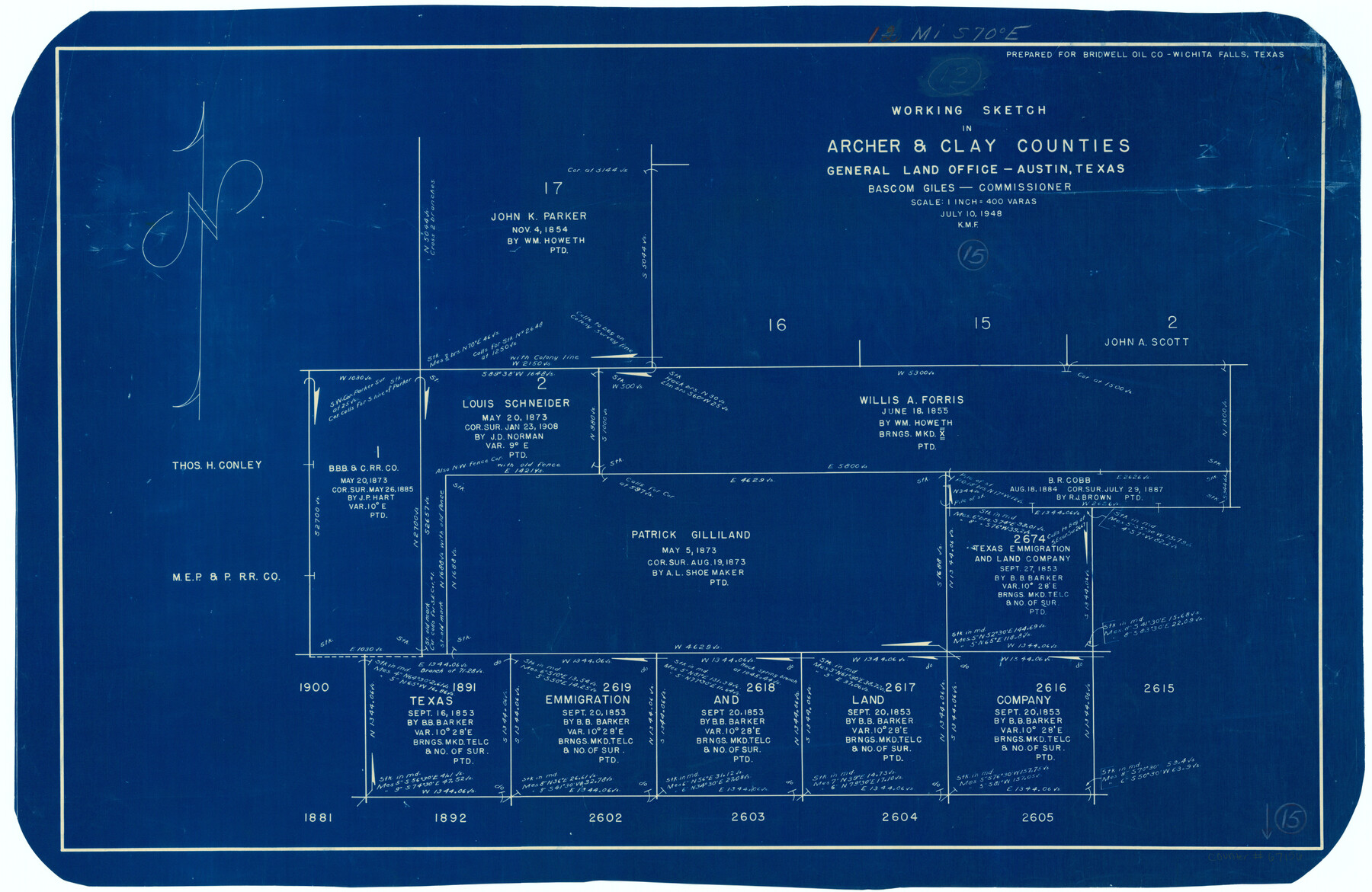
Archer County Working Sketch 15
-
Map/Doc
67156
-
Collection
General Map Collection
-
Object Dates
7/10/1948 (Creation Date)
-
People and Organizations
Bascom Giles (GLO Commissioner)
-
Counties
Archer Clay
-
Subjects
Surveying Working Sketch
-
Height x Width
20.7 x 31.9 inches
52.6 x 81.0 cm
-
Scale
1" = 400 varas
-
Comments
Surveys located about 12 miles South 70 degrees East of Archer City, Texas.
Part of: General Map Collection
Flight Mission No. BRE-1P, Frame 143, Nueces County

Print $20.00
- Digital $50.00
Flight Mission No. BRE-1P, Frame 143, Nueces County
1956
Size 18.3 x 22.2 inches
Map/Doc 86703
Brazoria County NRC Article 33.136 Sketch 17

Print $88.00
- Digital $50.00
Brazoria County NRC Article 33.136 Sketch 17
2015
Size 22.0 x 34.0 inches
Map/Doc 95020
Coke County Sketch File 17-18

Print $24.00
- Digital $50.00
Coke County Sketch File 17-18
1902
Size 16.6 x 14.2 inches
Map/Doc 11109
Upton County Sketch File 21

Print $20.00
- Digital $50.00
Upton County Sketch File 21
1927
Size 15.0 x 23.7 inches
Map/Doc 12518
Photo Index of Texas Coast - Sheet 6 of 6

Print $20.00
- Digital $50.00
Photo Index of Texas Coast - Sheet 6 of 6
1954
Size 20.0 x 24.0 inches
Map/Doc 83444

Cochran County Rolled Sketch 2

Print $20.00
- Digital $50.00
Cochran County Rolled Sketch 2
1940
Size 27.7 x 33.9 inches
Map/Doc 5500
Jeff Davis County Working Sketch 5

Print $20.00
- Digital $50.00
Jeff Davis County Working Sketch 5
1920
Size 12.9 x 22.2 inches
Map/Doc 66500

Burnet County Sketch File 27

Print $4.00
- Digital $50.00
Burnet County Sketch File 27
1874
Size 12.7 x 8.1 inches
Map/Doc 16730
McMullen County Rolled Sketch 18

Print $20.00
- Digital $50.00
McMullen County Rolled Sketch 18
Size 18.8 x 27.5 inches
Map/Doc 6734
Montgomery County Working Sketch 64

Print $20.00
- Digital $50.00
Montgomery County Working Sketch 64
1965
Size 27.9 x 33.7 inches
Map/Doc 71171
You may also like
Caddo Lake Subdivision, Copied from Sketch in MF 000964

Print $20.00
- Digital $50.00
Caddo Lake Subdivision, Copied from Sketch in MF 000964
1918
Size 32.5 x 28.0 inches
Map/Doc 1929
Thomas Kelly Subdivision in Parmer and Castro Counties, Texas

Print $20.00
- Digital $50.00
Thomas Kelly Subdivision in Parmer and Castro Counties, Texas
1906
Size 20.4 x 16.6 inches
Map/Doc 92549
Terrell County Working Sketch 77

Print $20.00
- Digital $50.00
Terrell County Working Sketch 77
1983
Size 22.9 x 33.7 inches
Map/Doc 69598
Map of Southeastern Part of Young Territory

Print $40.00
- Digital $50.00
Map of Southeastern Part of Young Territory
1874
Size 54.7 x 30.1 inches
Map/Doc 1989
General Highway Map, Crane County, Texas

Print $20.00
General Highway Map, Crane County, Texas
1961
Size 24.8 x 18.2 inches
Map/Doc 79424
Working Sketch Cochran and Yoakum Co's.

Print $40.00
- Digital $50.00
Working Sketch Cochran and Yoakum Co's.
1919
Size 54.2 x 14.5 inches
Map/Doc 89678
Harris County Rolled Sketch 44

Print $20.00
- Digital $50.00
Harris County Rolled Sketch 44
Size 22.5 x 29.9 inches
Map/Doc 6102
Flight Mission No. BQR-13K, Frame 25, Brazoria County

Print $20.00
- Digital $50.00
Flight Mission No. BQR-13K, Frame 25, Brazoria County
1952
Size 18.8 x 22.4 inches
Map/Doc 84073
Brazoria County NRC Article 33.136 Sketch 32

Print $24.00
Brazoria County NRC Article 33.136 Sketch 32
2025
Map/Doc 97490
Pecos County Rolled Sketch 175

Print $20.00
- Digital $50.00
Pecos County Rolled Sketch 175
Size 21.2 x 26.2 inches
Map/Doc 7295
San Antonio & Aransas Pass

Print $40.00
- Digital $50.00
San Antonio & Aransas Pass
Size 30.9 x 74.5 inches
Map/Doc 64633
Atascosa County Boundary File 2

Print $52.00
- Digital $50.00
Atascosa County Boundary File 2
Size 8.9 x 36.2 inches
Map/Doc 50160