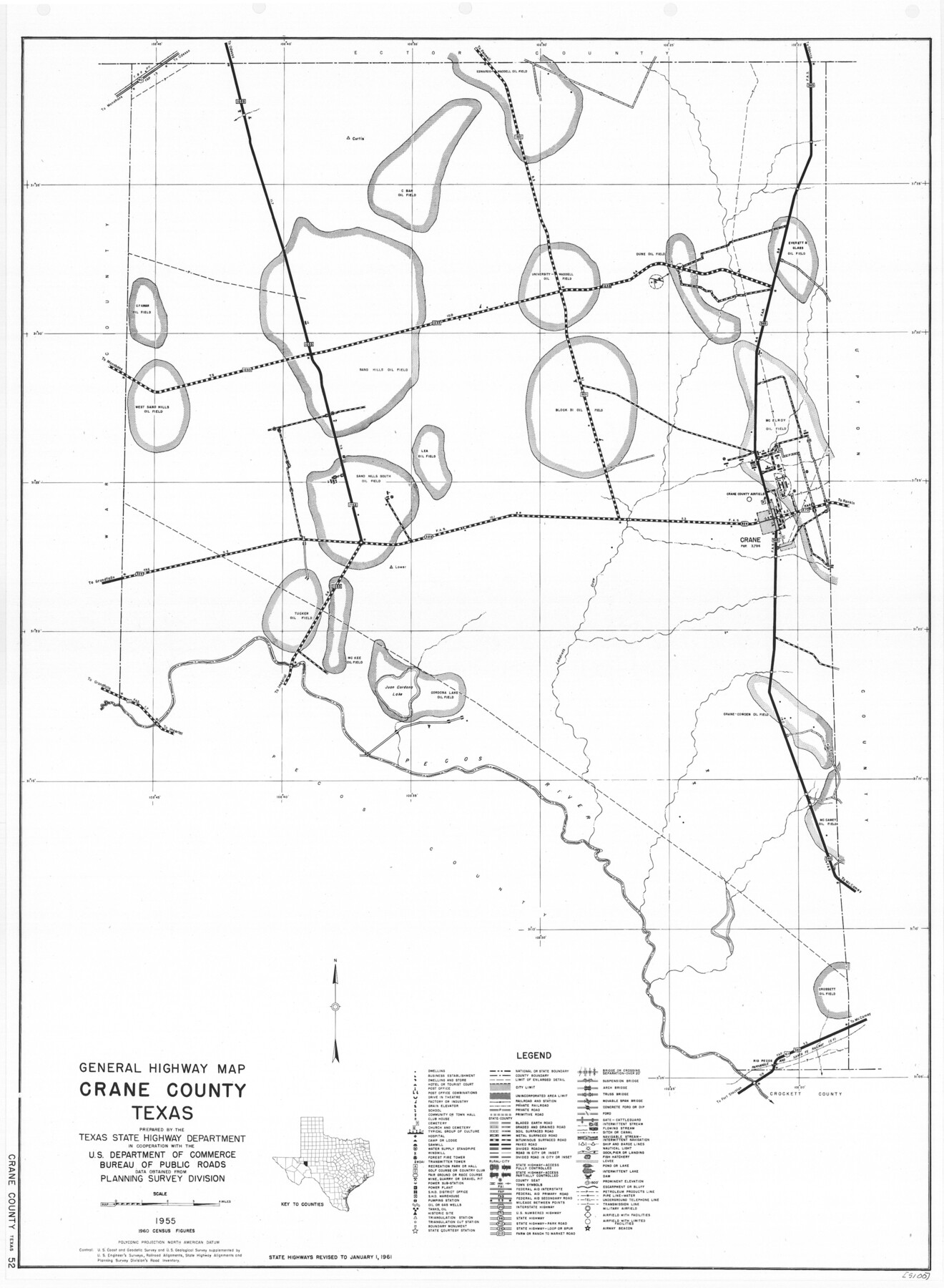
General Highway Map, Crane County, Texas
-
Map/Doc
79424
-
Collection
Texas State Library and Archives
-
Object Dates
1961 (Creation Date)
-
People and Organizations
Texas State Highway Department (Publisher)
-
Counties
Crane
-
Subjects
County
-
Height x Width
24.8 x 18.2 inches
63.0 x 46.2 cm
-
Comments
Prints available courtesy of the Texas State Library and Archives.
More info can be found here: TSLAC Map 05100
Part of: Texas State Library and Archives
General Highway Map, Houston County, Texas

Print $20.00
General Highway Map, Houston County, Texas
1961
Size 24.6 x 18.3 inches
Map/Doc 79524
General Highway Map. Detail of Cities and Towns in Travis County, Texas. City Map, Austin and vicinity, Travis County, Texas

Print $20.00
General Highway Map. Detail of Cities and Towns in Travis County, Texas. City Map, Austin and vicinity, Travis County, Texas
1961
Size 18.2 x 25.0 inches
Map/Doc 79685
General Highway Map, Bexar County, Texas

Print $20.00
General Highway Map, Bexar County, Texas
1940
Size 18.4 x 25.1 inches
Map/Doc 79016
General Highway Map. Detail of Cities and Towns in Smith County, Texas. City Map, Tyler and vicinity, Smith County, Texas

Print $20.00
General Highway Map. Detail of Cities and Towns in Smith County, Texas. City Map, Tyler and vicinity, Smith County, Texas
1961
Size 18.2 x 24.9 inches
Map/Doc 79657
General Highway Map, Jones County, Texas

Print $20.00
General Highway Map, Jones County, Texas
1940
Size 18.5 x 24.8 inches
Map/Doc 79150
General Highway Map, Williamson County, Texas

Print $20.00
General Highway Map, Williamson County, Texas
1940
Size 24.7 x 18.4 inches
Map/Doc 79281
Topographic Map of Texas and Oklahoma Boundary, Fort Augur Area

Print $20.00
Topographic Map of Texas and Oklahoma Boundary, Fort Augur Area
1924
Size 17.2 x 33.7 inches
Map/Doc 79754
General Highway Map, Brazoria County, Texas

Print $20.00
General Highway Map, Brazoria County, Texas
1961
Size 24.9 x 18.1 inches
Map/Doc 79383

General Highway Map, Karnes County, Texas

Print $20.00
General Highway Map, Karnes County, Texas
1961
Size 18.1 x 24.6 inches
Map/Doc 79547
General Highway Map. Detail of Cities and Towns in Bowie County, Texas

Print $20.00
General Highway Map. Detail of Cities and Towns in Bowie County, Texas
1961
Size 18.0 x 24.8 inches
Map/Doc 79381
General Highway Map, Stonewall County, Texas

Print $20.00
General Highway Map, Stonewall County, Texas
1961
Size 18.3 x 25.1 inches
Map/Doc 79662
You may also like
Flight Mission No. BRA-6M, Frame 78, Jefferson County

Print $20.00
- Digital $50.00
Flight Mission No. BRA-6M, Frame 78, Jefferson County
1953
Size 18.7 x 22.4 inches
Map/Doc 85422
Duval County Working Sketch 26

Print $20.00
- Digital $50.00
Duval County Working Sketch 26
1947
Size 34.8 x 36.9 inches
Map/Doc 68750
Lampasas County Boundary File 16a

Print $28.00
- Digital $50.00
Lampasas County Boundary File 16a
Size 13.9 x 8.4 inches
Map/Doc 56223
Wise County Sketch File 34

Print $6.00
- Digital $50.00
Wise County Sketch File 34
1856
Size 6.3 x 9.6 inches
Map/Doc 40592
Victoria County Sketch File 7

Print $6.00
- Digital $50.00
Victoria County Sketch File 7
1908
Size 11.4 x 17.4 inches
Map/Doc 12596
La Florida / Peruviae Avriferæ Regionis Typus / Guastecan

Print $20.00
- Digital $50.00
La Florida / Peruviae Avriferæ Regionis Typus / Guastecan
1584
Size 16.8 x 20.9 inches
Map/Doc 94100
Hood County Sketch File 7

Print $6.00
- Digital $50.00
Hood County Sketch File 7
Size 12.9 x 7.9 inches
Map/Doc 26581
Brazoria County Sketch File 54

Print $8.00
- Digital $50.00
Brazoria County Sketch File 54
1838
Size 13.4 x 8.2 inches
Map/Doc 15323
Terrell County Rolled Sketch 28

Print $40.00
- Digital $50.00
Terrell County Rolled Sketch 28
1929
Size 28.0 x 67.7 inches
Map/Doc 7935
[River Sections 58-62 and vicinity]
![91587, [River Sections 58-62 and vicinity], Twichell Survey Records](https://historictexasmaps.com/wmedia_w700/maps/91587-1.tif.jpg)
Print $20.00
- Digital $50.00
[River Sections 58-62 and vicinity]
Size 17.6 x 14.6 inches
Map/Doc 91587
Jeff Davis County Sketch File 42

Print $20.00
- Digital $50.00
Jeff Davis County Sketch File 42
Size 21.8 x 27.9 inches
Map/Doc 11867
Starr County Sketch File 42

Print $20.00
- Digital $50.00
Starr County Sketch File 42
1941
Size 19.0 x 21.6 inches
Map/Doc 12341