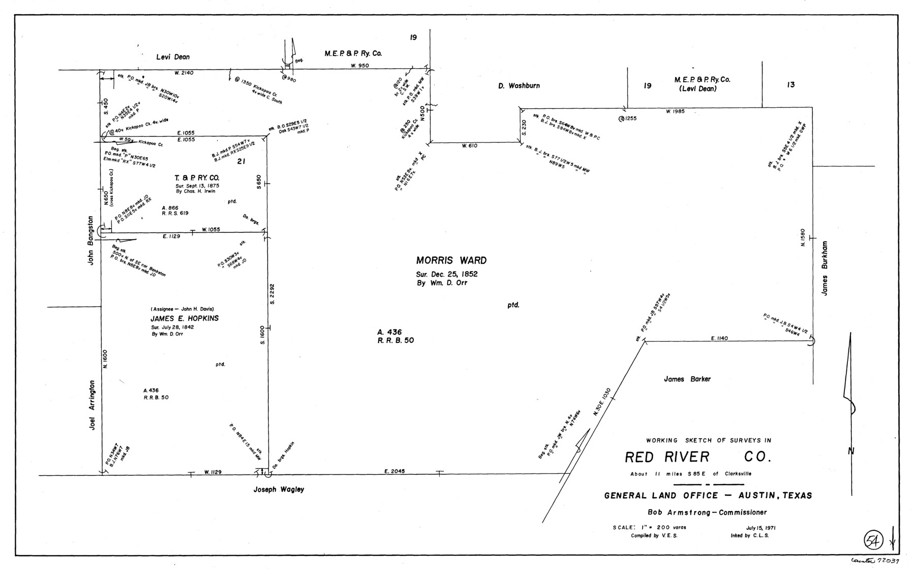
Red River County Working Sketch 54
-
Map/Doc
72037
-
Collection
General Map Collection
-
Object Dates
7/15/1971 (Creation Date)
-
People and Organizations
Victor E. Sterzing (Compiler)
Crockett L. Slover (Inker)
-
Counties
Red River
-
Subjects
Surveying Working Sketch
-
Height x Width
19.3 x 31.1 inches
49.0 x 79.0 cm
-
Scale
1" = 200 varas
Part of: General Map Collection
Red River, Bois D'Arc Creek Floodway Sheet No. 8

Print $20.00
- Digital $50.00
Red River, Bois D'Arc Creek Floodway Sheet No. 8
1928
Size 17.6 x 24.8 inches
Map/Doc 65272
Flight Mission No. DQN-6K, Frame 6, Calhoun County

Print $20.00
- Digital $50.00
Flight Mission No. DQN-6K, Frame 6, Calhoun County
1953
Size 18.5 x 22.2 inches
Map/Doc 84428
Grimes County Working Sketch 14

Print $20.00
- Digital $50.00
Grimes County Working Sketch 14
1983
Size 33.0 x 34.1 inches
Map/Doc 63305
Crockett County Rolled Sketch 48

Print $20.00
- Digital $50.00
Crockett County Rolled Sketch 48
1939
Size 30.0 x 40.3 inches
Map/Doc 8712
Hunt County Sketch File 49

Print $4.00
- Digital $50.00
Hunt County Sketch File 49
1852
Size 7.3 x 8.9 inches
Map/Doc 27168
Garza County Rolled Sketch 6B

Print $20.00
- Digital $50.00
Garza County Rolled Sketch 6B
Size 27.6 x 36.4 inches
Map/Doc 5996
San Saba County Sketch File 3

Print $4.00
- Digital $50.00
San Saba County Sketch File 3
1848
Size 12.5 x 7.9 inches
Map/Doc 36408
Flight Mission No. DIX-3P, Frame 169, Aransas County

Print $20.00
- Digital $50.00
Flight Mission No. DIX-3P, Frame 169, Aransas County
1956
Size 17.8 x 18.3 inches
Map/Doc 83775
County and Railroad Map of Texas

Print $20.00
- Digital $50.00
County and Railroad Map of Texas
1876
Size 17.0 x 16.0 inches
Map/Doc 93624
Reeves County Sketch File 9

Print $20.00
- Digital $50.00
Reeves County Sketch File 9
Size 46.3 x 38.2 inches
Map/Doc 10587
Brewster County Sketch File NS-12

Print $40.00
- Digital $50.00
Brewster County Sketch File NS-12
Size 18.0 x 23.0 inches
Map/Doc 10990
Flight Mission No. BRA-7M, Frame 43, Jefferson County

Print $20.00
- Digital $50.00
Flight Mission No. BRA-7M, Frame 43, Jefferson County
1953
Size 18.6 x 22.4 inches
Map/Doc 85494
You may also like
Clay County Boundary File 15

Print $8.00
- Digital $50.00
Clay County Boundary File 15
Size 13.3 x 8.2 inches
Map/Doc 51418
Travis County Rolled Sketch 28

Print $20.00
- Digital $50.00
Travis County Rolled Sketch 28
1941
Size 22.7 x 27.0 inches
Map/Doc 8030
Runnels County Working Sketch 24

Print $20.00
- Digital $50.00
Runnels County Working Sketch 24
1952
Size 30.6 x 20.0 inches
Map/Doc 63620
Robertson County Working Sketch 18

Print $20.00
- Digital $50.00
Robertson County Working Sketch 18
1995
Size 29.9 x 34.1 inches
Map/Doc 63591
Deaf Smith County Sketch File B

Print $20.00
- Digital $50.00
Deaf Smith County Sketch File B
Size 17.0 x 14.9 inches
Map/Doc 20626

Louisiana and Texas Intracoastal Waterway

Print $20.00
- Digital $50.00
Louisiana and Texas Intracoastal Waterway
1929
Size 13.8 x 19.9 inches
Map/Doc 83341
Runnels County Sketch File 37

Print $20.00
Runnels County Sketch File 37
1889
Size 24.9 x 21.3 inches
Map/Doc 12268
Flight Mission No. BRA-7M, Frame 40, Jefferson County

Print $20.00
- Digital $50.00
Flight Mission No. BRA-7M, Frame 40, Jefferson County
1953
Size 18.7 x 22.3 inches
Map/Doc 85491
J. De Cordova's Map of the State of Texas Compiled from the records of the General Land Office of the State

Print $20.00
- Digital $50.00
J. De Cordova's Map of the State of Texas Compiled from the records of the General Land Office of the State
1849
Size 36.0 x 34.0 inches
Map/Doc 93930
The Republic County of Jackson. January 19, 1841

Print $20.00
The Republic County of Jackson. January 19, 1841
2020
Size 15.6 x 21.8 inches
Map/Doc 96188
Ellis County Sketch File 1

Print $6.00
- Digital $50.00
Ellis County Sketch File 1
1849
Size 6.5 x 7.9 inches
Map/Doc 21824