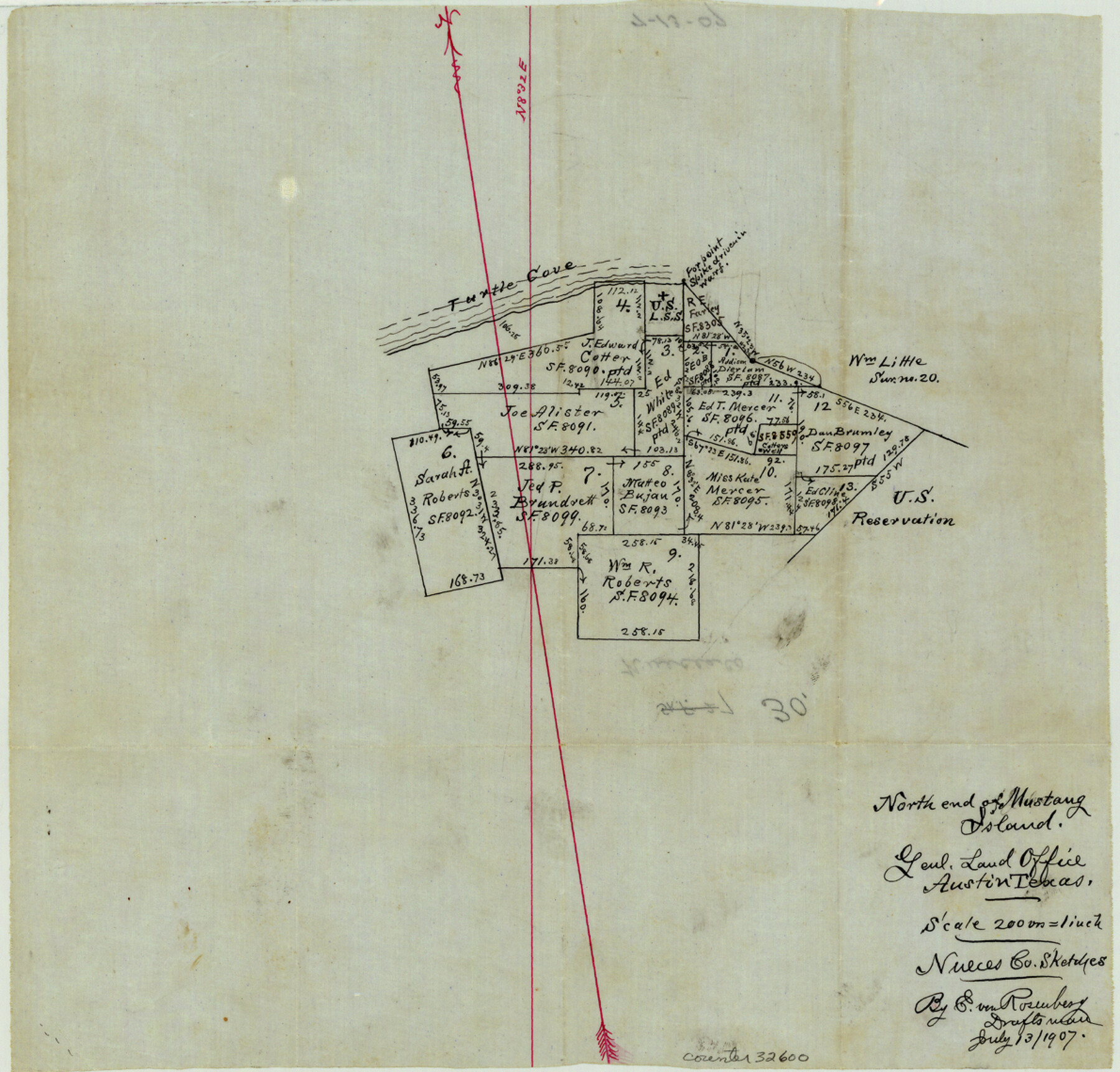
Nueces County Sketch File 30
[Office sketch of north end of Mustang Island]
-
Map/Doc
32600
-
Collection
General Map Collection
-
Object Dates
7/13/1907 (Creation Date)
7/13/1907 (File Date)
-
People and Organizations
E. von Rosenberg (Draftsman)
-
Counties
Nueces
-
Subjects
Surveying Sketch File
-
Height x Width
11.4 x 11.9 inches
29.0 x 30.2 cm
-
Medium
paper, manuscript
-
Scale
1" = 200 varas
-
Features
Turtle Cove
Mustang Island
Part of: General Map Collection
Carta Esferica que comprehende las costas del Seno Mexicano construida de orden del rey en el deposito hidrografico de marina: Por disposicion del Exmo. Señor Don Juan de Langara, Secretario de Estado y del Despacho Universal de ella. Año de 1799.

Print $20.00
- Digital $50.00
Carta Esferica que comprehende las costas del Seno Mexicano construida de orden del rey en el deposito hidrografico de marina: Por disposicion del Exmo. Señor Don Juan de Langara, Secretario de Estado y del Despacho Universal de ella. Año de 1799.
1799
Size 25.9 x 37.3 inches
Map/Doc 95367
Flight Mission No. DQO-2K, Frame 144, Galveston County

Print $20.00
- Digital $50.00
Flight Mission No. DQO-2K, Frame 144, Galveston County
1952
Size 18.8 x 22.5 inches
Map/Doc 85041
Uvalde County Working Sketch 55

Print $20.00
- Digital $50.00
Uvalde County Working Sketch 55
1983
Size 38.9 x 37.6 inches
Map/Doc 72125
Morris County Sketch File 4

Print $4.00
- Digital $50.00
Morris County Sketch File 4
1910
Size 8.3 x 8.6 inches
Map/Doc 31968
Edwards County Working Sketch 117

Print $20.00
- Digital $50.00
Edwards County Working Sketch 117
1974
Size 31.4 x 44.1 inches
Map/Doc 68993
Henderson County Boundary File 3c

Print $40.00
- Digital $50.00
Henderson County Boundary File 3c
Size 22.5 x 80.6 inches
Map/Doc 54707

Frio County Sketch File 22

Print $10.00
- Digital $50.00
Frio County Sketch File 22
1994
Size 11.4 x 8.6 inches
Map/Doc 23162
Stonewall County Working Sketch 22

Print $20.00
- Digital $50.00
Stonewall County Working Sketch 22
1966
Size 44.2 x 32.9 inches
Map/Doc 62329
Cameron County Rolled Sketch 19

Print $20.00
- Digital $50.00
Cameron County Rolled Sketch 19
Size 25.8 x 23.6 inches
Map/Doc 5465
Harris County Historic Topographic 19

Print $20.00
- Digital $50.00
Harris County Historic Topographic 19
1915
Size 29.3 x 22.6 inches
Map/Doc 65830
Pecos County Rolled Sketch 69

Print $20.00
- Digital $50.00
Pecos County Rolled Sketch 69
Size 37.9 x 33.8 inches
Map/Doc 9701
You may also like
[Jesse Folk and Surrounding Surveys]
![91087, [Jesse Folk and Surrounding Surveys], Twichell Survey Records](https://historictexasmaps.com/wmedia_w700/maps/91087-1.tif.jpg)
Print $20.00
- Digital $50.00
[Jesse Folk and Surrounding Surveys]
1922
Size 21.8 x 33.7 inches
Map/Doc 91087
Map of Shackelford County, North of the Clearfork of the Brazos River Young - South of il Milam - Land District

Print $20.00
- Digital $50.00
Map of Shackelford County, North of the Clearfork of the Brazos River Young - South of il Milam - Land District
1859
Size 24.8 x 19.9 inches
Map/Doc 4027
Knox County Sketch File 10

Print $20.00
- Digital $50.00
Knox County Sketch File 10
1889
Size 20.1 x 12.8 inches
Map/Doc 11958
Foard County Boundary File 3

Print $48.00
- Digital $50.00
Foard County Boundary File 3
Size 24.2 x 6.0 inches
Map/Doc 53516
Brewster County Sketch File N-12

Print $4.00
- Digital $50.00
Brewster County Sketch File N-12
1933
Size 14.3 x 9.0 inches
Map/Doc 15623
Carte Générale des États-Unis pour servir a l'Histoire de la Louisiane

Print $20.00
- Digital $50.00
Carte Générale des États-Unis pour servir a l'Histoire de la Louisiane
1829
Size 12.0 x 15.9 inches
Map/Doc 97260
Moore County Working Sketch 15

Print $20.00
- Digital $50.00
Moore County Working Sketch 15
1981
Size 20.8 x 35.3 inches
Map/Doc 71197
Terry County Boundary File 5

Print $2.00
- Digital $50.00
Terry County Boundary File 5
Size 14.2 x 8.9 inches
Map/Doc 59257
Flight Mission No. CGI-3N, Frame 110, Cameron County

Print $20.00
- Digital $50.00
Flight Mission No. CGI-3N, Frame 110, Cameron County
1954
Size 18.5 x 22.1 inches
Map/Doc 84590
Motley County Boundary File 2

Print $10.00
- Digital $50.00
Motley County Boundary File 2
Size 7.1 x 4.3 inches
Map/Doc 57506
Schleicher County Sketch File 23a

Print $4.00
- Digital $50.00
Schleicher County Sketch File 23a
1937
Size 11.3 x 8.8 inches
Map/Doc 36514
Shelby County Rolled Sketch 6

Print $20.00
- Digital $50.00
Shelby County Rolled Sketch 6
Size 26.7 x 20.9 inches
Map/Doc 7776