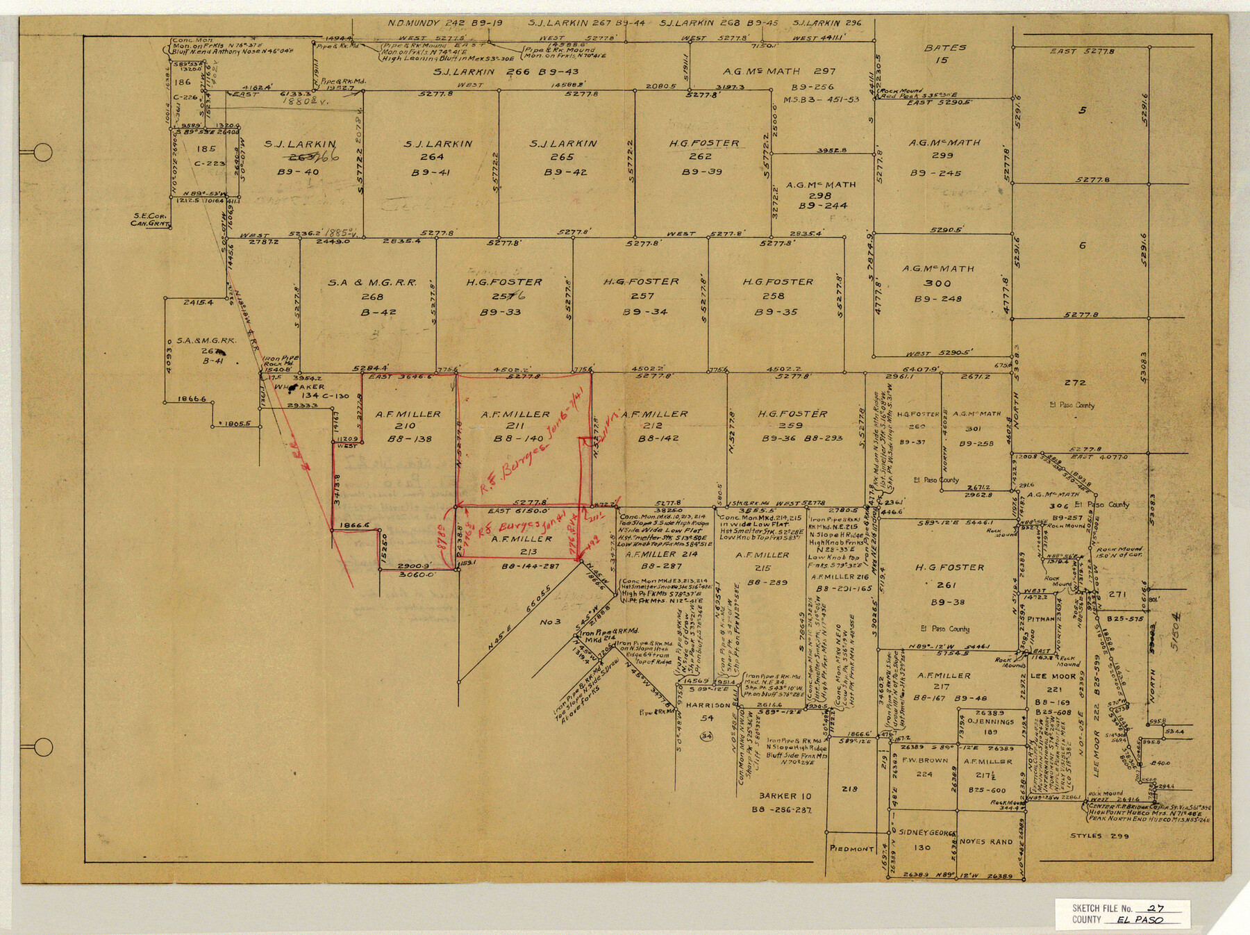
El Paso County Sketch File 27
[Sketch of surveys northwest from El Paso]
-
Map/Doc
11458
-
Collection
General Map Collection
-
Object Dates
8/8/1944 (File Date)
-
Counties
El Paso
-
Subjects
Surveying Sketch File
-
Height x Width
18.3 x 24.5 inches
46.5 x 62.2 cm
-
Medium
paper, manuscript
Part of: General Map Collection
Edwards County Working Sketch 28

Print $20.00
- Digital $50.00
Edwards County Working Sketch 28
1946
Size 30.0 x 33.5 inches
Map/Doc 68904
Flight Mission No. CGI-3N, Frame 141, Cameron County

Print $20.00
- Digital $50.00
Flight Mission No. CGI-3N, Frame 141, Cameron County
1954
Size 18.6 x 22.3 inches
Map/Doc 84614
Flight Mission No. CUG-3P, Frame 171, Kleberg County

Print $20.00
- Digital $50.00
Flight Mission No. CUG-3P, Frame 171, Kleberg County
1956
Size 18.4 x 22.3 inches
Map/Doc 86291

Flight Mission No. DQO-1K, Frame 117, Galveston County

Print $20.00
- Digital $50.00
Flight Mission No. DQO-1K, Frame 117, Galveston County
1952
Size 18.9 x 22.5 inches
Map/Doc 84995
[Cameron County]
![3365, [Cameron County], General Map Collection](https://historictexasmaps.com/wmedia_w700/maps/3365-2.tif.jpg)
Print $20.00
- Digital $50.00
[Cameron County]
Size 19.2 x 21.8 inches
Map/Doc 3365
[St. Louis & Southwestern]
![64278, [St. Louis & Southwestern], General Map Collection](https://historictexasmaps.com/wmedia_w700/maps/64278.tif.jpg)
Print $20.00
- Digital $50.00
[St. Louis & Southwestern]
Size 20.8 x 28.9 inches
Map/Doc 64278
Hemphill County Rolled Sketch 15A

Print $20.00
- Digital $50.00
Hemphill County Rolled Sketch 15A
1961
Size 26.6 x 17.3 inches
Map/Doc 6195
Jack County Sketch File 26

Print $4.00
- Digital $50.00
Jack County Sketch File 26
1891
Size 8.7 x 9.3 inches
Map/Doc 27563
Acreage in Texas by Counties

Acreage in Texas by Counties
1983
Size 10.3 x 11.8 inches
Map/Doc 97033
Jackson County Rolled Sketch 11

Print $20.00
- Digital $50.00
Jackson County Rolled Sketch 11
1941
Size 45.9 x 34.3 inches
Map/Doc 9260
Brazoria County NRC Article 33.136 Sketch 17

Print $88.00
- Digital $50.00
Brazoria County NRC Article 33.136 Sketch 17
2015
Size 22.0 x 34.0 inches
Map/Doc 95020
You may also like
Newton County Rolled Sketch 16

Print $20.00
- Digital $50.00
Newton County Rolled Sketch 16
Size 30.5 x 21.9 inches
Map/Doc 6846
Howard County Rolled Sketch 9

Print $20.00
- Digital $50.00
Howard County Rolled Sketch 9
1940
Size 35.2 x 26.9 inches
Map/Doc 6239
Aransas County NRC Article 33.136 Sketch 6

Print $23.00
- Digital $50.00
Aransas County NRC Article 33.136 Sketch 6
2005
Size 25.1 x 36.4 inches
Map/Doc 83522
Fort Bend County Rolled Sketch C

Print $20.00
- Digital $50.00
Fort Bend County Rolled Sketch C
Size 12.7 x 16.6 inches
Map/Doc 5905
Cooke County Working Sketch 37

Print $20.00
- Digital $50.00
Cooke County Working Sketch 37
1995
Size 21.7 x 18.9 inches
Map/Doc 68274
Bosque County Sketch File 6

Print $4.00
- Digital $50.00
Bosque County Sketch File 6
1851
Size 12.1 x 7.6 inches
Map/Doc 14748
Flight Mission No. CRE-1R, Frame 124, Jackson County

Print $20.00
- Digital $50.00
Flight Mission No. CRE-1R, Frame 124, Jackson County
1956
Size 16.1 x 15.9 inches
Map/Doc 85335
Dickens County Sketch File 14a

Print $20.00
- Digital $50.00
Dickens County Sketch File 14a
Size 18.2 x 16.5 inches
Map/Doc 11321
Medina County Working Sketch 13

Print $20.00
- Digital $50.00
Medina County Working Sketch 13
1972
Size 31.5 x 39.0 inches
Map/Doc 70928
Dallas County

Print $20.00
- Digital $50.00
Dallas County
1942
Size 45.5 x 38.0 inches
Map/Doc 16954
Section 1, Block AX, Gaines County, Texas

Print $3.00
- Digital $50.00
Section 1, Block AX, Gaines County, Texas
1952
Size 11.1 x 13.1 inches
Map/Doc 92670
Jeff Davis County Sketch File 28

Print $30.00
- Digital $50.00
Jeff Davis County Sketch File 28
1916
Size 7.2 x 8.7 inches
Map/Doc 28003