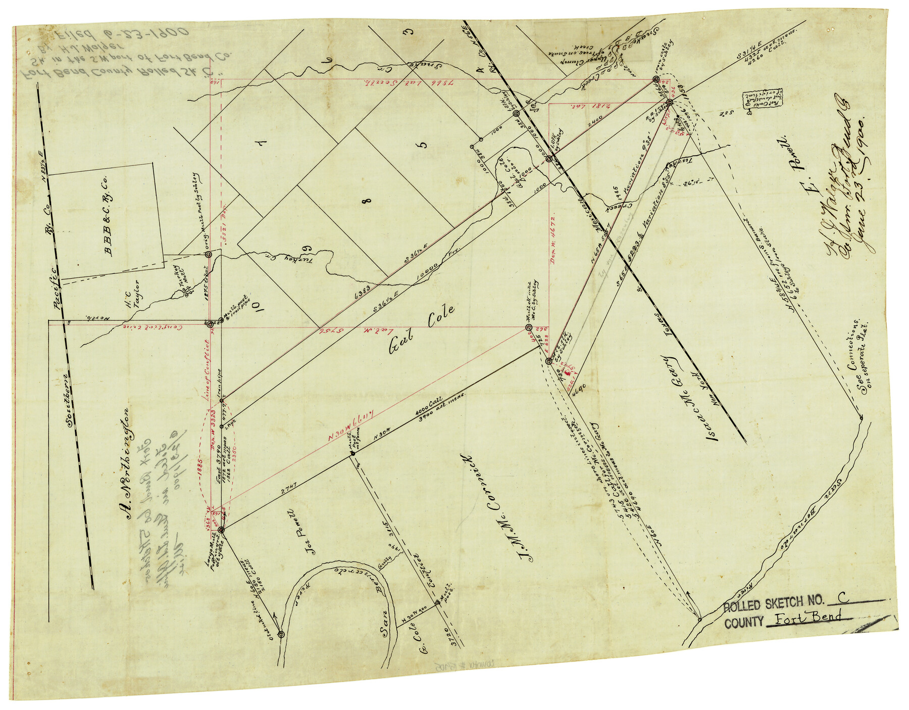
Fort Bend County Rolled Sketch C
[Sketch in the SW part of Fort Bend County]
-
Map/Doc
5905
-
Collection
General Map Collection
-
Object Dates
6/23/1900 (File Date)
-
People and Organizations
H.J. Walger (Surveyor/Engineer)
-
Counties
Fort Bend
-
Subjects
Surveying Rolled Sketch
-
Height x Width
12.7 x 16.6 inches
32.3 x 42.2 cm
-
Medium
linen, manuscript
Part of: General Map Collection
Baylor County Boundary File 14

Print $6.00
- Digital $50.00
Baylor County Boundary File 14
Size 11.1 x 8.6 inches
Map/Doc 50428
Flight Mission No. BRE-1P, Frame 46, Nueces County

Print $20.00
- Digital $50.00
Flight Mission No. BRE-1P, Frame 46, Nueces County
1956
Size 16.4 x 16.2 inches
Map/Doc 86635
Current Miscellaneous File 24

Print $26.00
- Digital $50.00
Current Miscellaneous File 24
1953
Size 10.6 x 8.2 inches
Map/Doc 73883
Pecos County Sketch File 73

Print $48.00
- Digital $50.00
Pecos County Sketch File 73
1940
Size 8.9 x 9.1 inches
Map/Doc 33876
Pecos County Rolled Sketch 29

Print $40.00
- Digital $50.00
Pecos County Rolled Sketch 29
1890
Size 27.3 x 49.9 inches
Map/Doc 9690
Flight Mission No. CUG-2P, Frame 21, Kleberg County

Print $20.00
- Digital $50.00
Flight Mission No. CUG-2P, Frame 21, Kleberg County
1956
Size 18.5 x 22.3 inches
Map/Doc 86185
[Surveys in Power and Hewetson's Colony along the Blanco and Medina Rivers]
![46, [Surveys in Power and Hewetson's Colony along the Blanco and Medina Rivers], General Map Collection](https://historictexasmaps.com/wmedia_w700/maps/46.tif.jpg)
Print $20.00
- Digital $50.00
[Surveys in Power and Hewetson's Colony along the Blanco and Medina Rivers]
1834
Size 37.0 x 29.9 inches
Map/Doc 46
El Paso County Sketch File 31

Print $185.00
- Digital $50.00
El Paso County Sketch File 31
1968
Size 8.9 x 17.7 inches
Map/Doc 22084
Map of Freestone County

Print $20.00
- Digital $50.00
Map of Freestone County
1874
Size 21.8 x 24.5 inches
Map/Doc 3563
Parker County Working Sketch 1

Print $20.00
- Digital $50.00
Parker County Working Sketch 1
Size 22.6 x 17.0 inches
Map/Doc 71451
Austin County Working Sketch 3

Print $20.00
- Digital $50.00
Austin County Working Sketch 3
1950
Size 33.3 x 40.1 inches
Map/Doc 67244
Wharton County

Print $20.00
- Digital $50.00
Wharton County
1946
Size 41.4 x 46.9 inches
Map/Doc 77455
You may also like
Hall County, Texas

Print $20.00
- Digital $50.00
Hall County, Texas
1880
Size 24.9 x 20.4 inches
Map/Doc 480
[Block V and surrounding surveys]
![90293, [Block V and surrounding surveys], Twichell Survey Records](https://historictexasmaps.com/wmedia_w700/maps/90293-1.tif.jpg)
Print $20.00
- Digital $50.00
[Block V and surrounding surveys]
Size 12.0 x 12.6 inches
Map/Doc 90293
Burnet County Working Sketch 26

Print $20.00
- Digital $50.00
Burnet County Working Sketch 26
2016
Size 18.7 x 24.8 inches
Map/Doc 93979
Wichita County Rolled Sketch 17

Print $117.00
- Digital $50.00
Wichita County Rolled Sketch 17
Size 10.4 x 15.4 inches
Map/Doc 49488
Presidio County Working Sketch Graphic Index, West Part, Sheet 1 (Sketches 1 to 74)

Print $20.00
- Digital $50.00
Presidio County Working Sketch Graphic Index, West Part, Sheet 1 (Sketches 1 to 74)
1974
Size 40.3 x 31.4 inches
Map/Doc 76672
Edwards County Boundary File 27

Print $8.00
- Digital $50.00
Edwards County Boundary File 27
Size 8.8 x 3.9 inches
Map/Doc 52876
Jeff Davis County Rolled Sketch 23A

Print $11.00
- Digital $50.00
Jeff Davis County Rolled Sketch 23A
1886
Size 9.9 x 15.3 inches
Map/Doc 46293
Controlled Mosaic by Jack Amman Photogrammetric Engineers, Inc - Sheet 53

Print $20.00
- Digital $50.00
Controlled Mosaic by Jack Amman Photogrammetric Engineers, Inc - Sheet 53
1954
Size 20.0 x 24.0 inches
Map/Doc 83512
[H. & T. C. Block 46]
![92980, [H. & T. C. Block 46], Twichell Survey Records](https://historictexasmaps.com/wmedia_w700/maps/92980-1.tif.jpg)
Print $20.00
- Digital $50.00
[H. & T. C. Block 46]
Size 28.5 x 17.9 inches
Map/Doc 92980
Galveston Bay from a Spanish M. S.

Print $20.00
- Digital $50.00
Galveston Bay from a Spanish M. S.
1846
Size 25.1 x 18.2 inches
Map/Doc 72759
Midland County Sketch File 9

Print $20.00
- Digital $50.00
Midland County Sketch File 9
Size 19.7 x 29.2 inches
Map/Doc 12085
Tyler County Sketch File 15

Print $6.00
- Digital $50.00
Tyler County Sketch File 15
1857
Size 10.4 x 7.5 inches
Map/Doc 38658