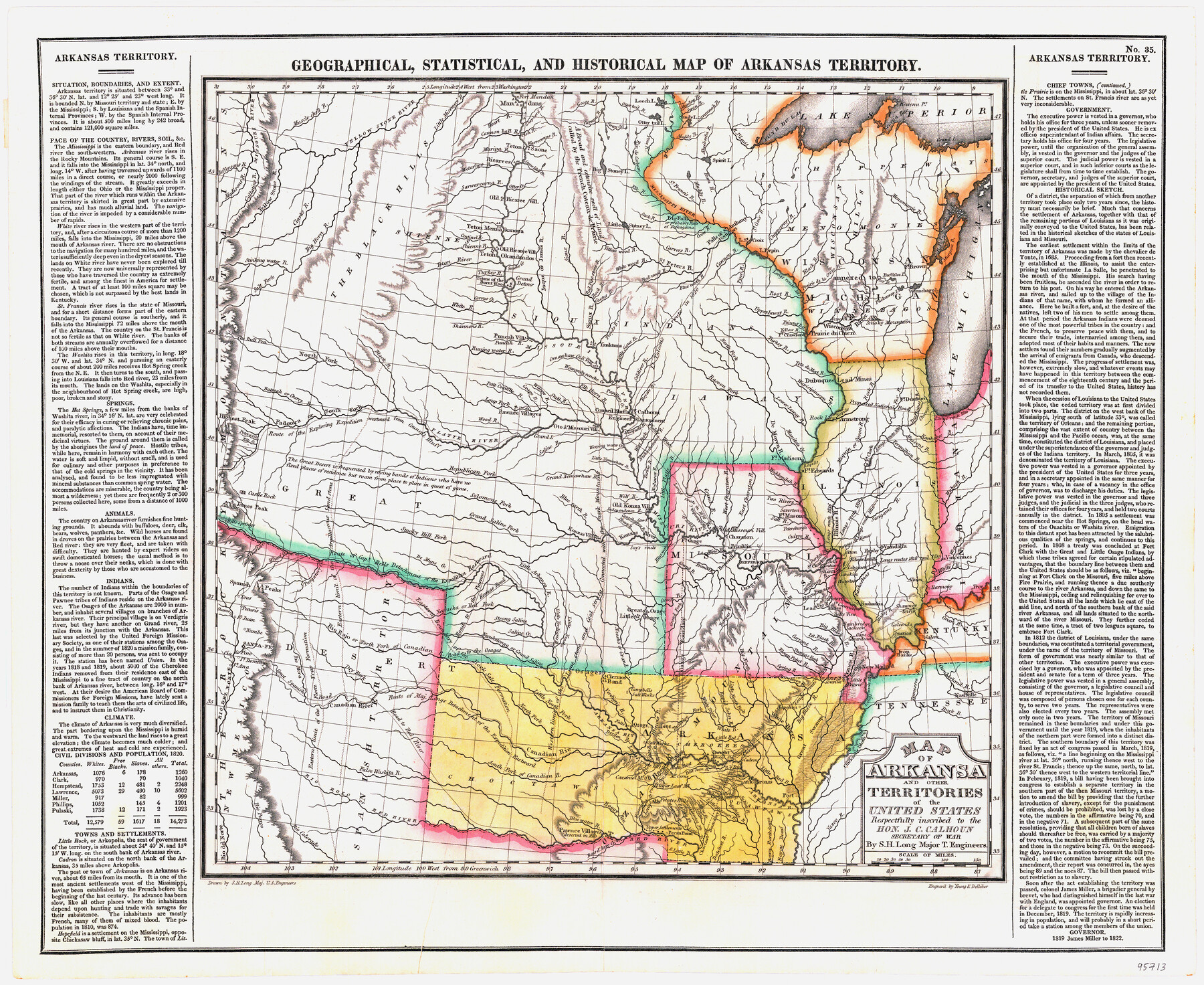
Geographical, Statistical, and Historical Map of Arkansas Territory
Map of Arkansa [sic] and other Territories of the United States
-
Map/Doc
95713
-
Collection
General Map Collection
-
Object Dates
1822 (Creation Date)
-
People and Organizations
H.C. Carey, I. Lea (Publisher)
Young & Delleker (Printer)
S.H. Long (Draftsman)
-
Subjects
United States
-
Height x Width
17.9 x 21.9 inches
45.5 x 55.6 cm
-
Medium
paper, etching/engraving/lithograph
-
Comments
Map is from Carey & Lea's publication "A Complete Historical, Chronological, And Geographical American Atlas"
Part of: General Map Collection
Flight Mission No. DIX-5P, Frame 140, Aransas County

Print $20.00
- Digital $50.00
Flight Mission No. DIX-5P, Frame 140, Aransas County
1956
Size 17.8 x 18.5 inches
Map/Doc 83801
Map of Zavalla County

Print $20.00
- Digital $50.00
Map of Zavalla County
1876
Size 22.5 x 33.2 inches
Map/Doc 4181
Map of Liberty County Texas

Print $20.00
- Digital $50.00
Map of Liberty County Texas
1879
Size 25.4 x 25.3 inches
Map/Doc 42994
Kenedy County Sketch File 2

Print $130.00
- Digital $50.00
Kenedy County Sketch File 2
1995
Size 11.2 x 8.7 inches
Map/Doc 28773
Uvalde County Working Sketch 31

Print $20.00
- Digital $50.00
Uvalde County Working Sketch 31
1962
Size 28.5 x 43.0 inches
Map/Doc 72101

Crosby County Boundary File 3

Print $2.00
- Digital $50.00
Crosby County Boundary File 3
Size 11.2 x 8.7 inches
Map/Doc 52002
Located Line of the Panhandle & Gulf Ry. through State Lands, Public School and University, in Upton County Texas, Right of Way 200 feet wide

Print $40.00
- Digital $50.00
Located Line of the Panhandle & Gulf Ry. through State Lands, Public School and University, in Upton County Texas, Right of Way 200 feet wide
Size 13.3 x 102.6 inches
Map/Doc 64052
Donley County

Print $20.00
- Digital $50.00
Donley County
1944
Size 46.8 x 40.6 inches
Map/Doc 95484
Liberty County Sketch File 32

Print $8.00
- Digital $50.00
Liberty County Sketch File 32
1872
Size 10.3 x 8.2 inches
Map/Doc 29961
Smith County Sketch File 7

Print $4.00
- Digital $50.00
Smith County Sketch File 7
1848
Size 12.7 x 8.2 inches
Map/Doc 36759
Kleberg County Rolled Sketch 10-8

Print $20.00
- Digital $50.00
Kleberg County Rolled Sketch 10-8
1951
Size 36.6 x 33.7 inches
Map/Doc 9370
You may also like
McLennan County Boundary File 1a

Print $14.00
- Digital $50.00
McLennan County Boundary File 1a
Size 8.0 x 6.6 inches
Map/Doc 56941
Presidio County Sketch File 112

Print $166.00
- Digital $50.00
Presidio County Sketch File 112
1983
Size 12.1 x 31.2 inches
Map/Doc 11727
Americae Sive Novi Orbis, Nova Descriptio

Print $20.00
- Digital $50.00
Americae Sive Novi Orbis, Nova Descriptio
1573
Size 15.6 x 22.3 inches
Map/Doc 95834
Flight Mission No. CGI-3N, Frame 75, Cameron County

Print $20.00
- Digital $50.00
Flight Mission No. CGI-3N, Frame 75, Cameron County
1954
Size 18.6 x 22.2 inches
Map/Doc 84569
Presidio County Rolled Sketch 74

Print $20.00
- Digital $50.00
Presidio County Rolled Sketch 74
Size 20.5 x 14.0 inches
Map/Doc 7362
Wichita County

Print $20.00
- Digital $50.00
Wichita County
1924
Size 33.7 x 40.2 inches
Map/Doc 63123
[Surveys in Chambers County, along East Bay Bayou and Elm Bayou]
![69752, [Surveys in Chambers County, along East Bay Bayou and Elm Bayou], General Map Collection](https://historictexasmaps.com/wmedia_w700/maps/69752.tif.jpg)
Print $2.00
- Digital $50.00
[Surveys in Chambers County, along East Bay Bayou and Elm Bayou]
1847
Size 7.5 x 9.3 inches
Map/Doc 69752
Wise County Working Sketch 20

Print $20.00
- Digital $50.00
Wise County Working Sketch 20
1979
Size 22.8 x 27.3 inches
Map/Doc 72634
Galveston County NRC Article 33.136 Sketch 67

Print $28.00
- Digital $50.00
Galveston County NRC Article 33.136 Sketch 67
2011
Size 17.0 x 24.0 inches
Map/Doc 93391
Gaines County Boundary File 1

Print $90.00
- Digital $50.00
Gaines County Boundary File 1
Size 14.4 x 9.0 inches
Map/Doc 53626
Montgomery County Rolled Sketch 27

Print $20.00
- Digital $50.00
Montgomery County Rolled Sketch 27
Size 34.5 x 34.4 inches
Map/Doc 9536
Lamar County Sketch File 9

Print $6.00
- Digital $50.00
Lamar County Sketch File 9
1872
Size 10.1 x 7.9 inches
Map/Doc 29290