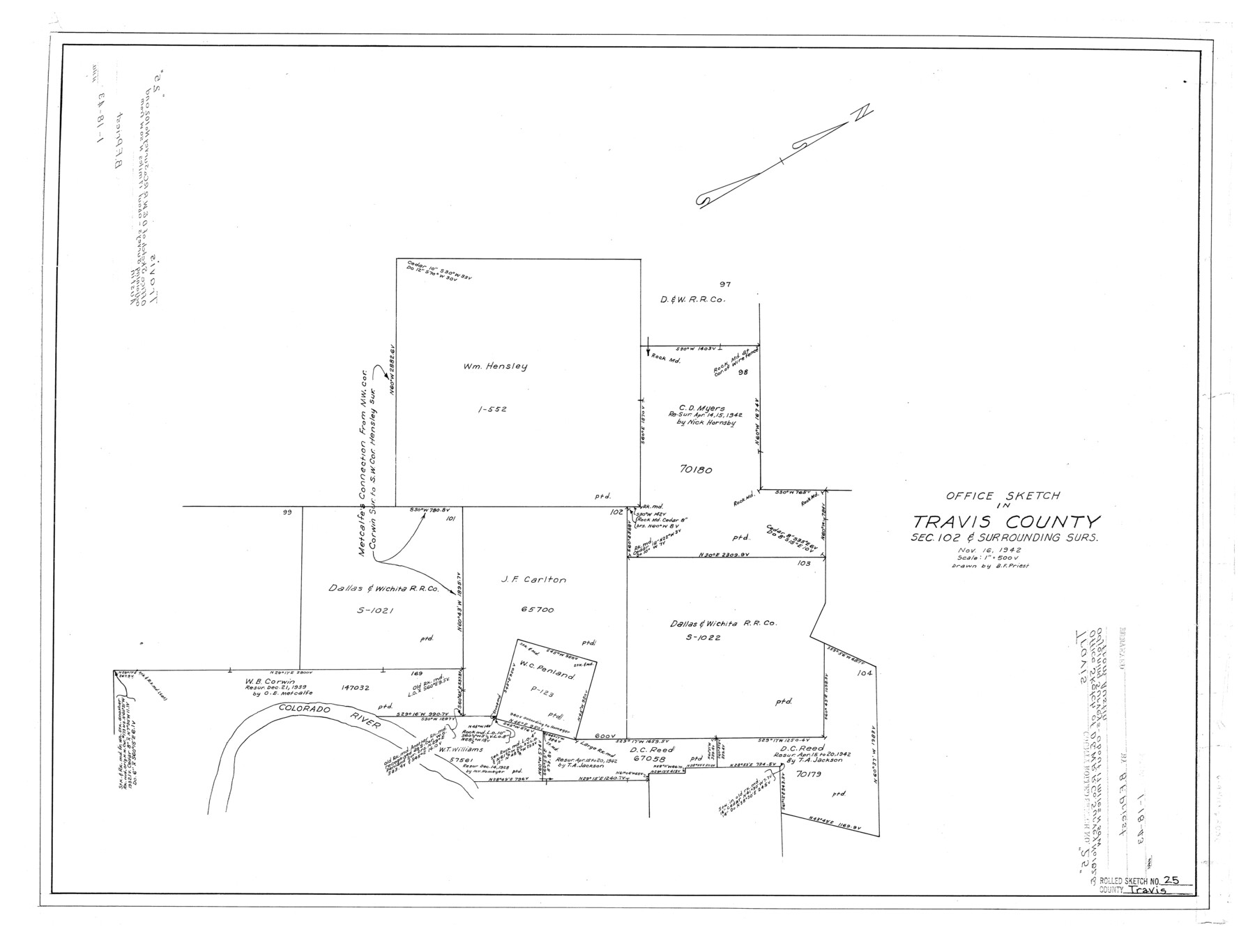
Travis County Rolled Sketch 25
Office sketch in Travis County, sec. 102 & surrounding surs.
-
Map/Doc
8026
-
Collection
General Map Collection
-
Object Dates
1943/1/18 (File Date)
1942/11/16 (Creation Date)
-
People and Organizations
B.F. Priest (Draftsman)
-
Counties
Travis
-
Subjects
Surveying Rolled Sketch
-
Height x Width
22.1 x 29.2 inches
56.1 x 74.2 cm
-
Scale
1" = 500 varas
Part of: General Map Collection
Flight Mission No. BRA-3M, Frame 193, Jefferson County

Print $20.00
- Digital $50.00
Flight Mission No. BRA-3M, Frame 193, Jefferson County
1953
Size 18.6 x 22.3 inches
Map/Doc 85408
Pecos County Working Sketch 107

Print $40.00
- Digital $50.00
Pecos County Working Sketch 107
1971
Size 55.3 x 37.4 inches
Map/Doc 71580
Sutton County Sketch File 52

Print $6.00
- Digital $50.00
Sutton County Sketch File 52
1948
Size 11.2 x 8.8 inches
Map/Doc 37529
Montague County Working Sketch 14

Print $20.00
- Digital $50.00
Montague County Working Sketch 14
1940
Size 28.4 x 17.9 inches
Map/Doc 71080
Cass County Rolled Sketch 5B

Print $20.00
- Digital $50.00
Cass County Rolled Sketch 5B
1949
Size 23.5 x 16.4 inches
Map/Doc 5412
Lee County Sketch File 4a

Print $4.00
- Digital $50.00
Lee County Sketch File 4a
1860
Size 12.9 x 8.2 inches
Map/Doc 29684
Maverick County Sketch File 6

Print $8.00
- Digital $50.00
Maverick County Sketch File 6
Size 12.7 x 8.2 inches
Map/Doc 31053
Nueces County Working Sketch Graphic Index

Print $20.00
- Digital $50.00
Nueces County Working Sketch Graphic Index
1913
Size 24.0 x 32.3 inches
Map/Doc 76655

Wichita County Working Sketch 16

Print $20.00
- Digital $50.00
Wichita County Working Sketch 16
1939
Size 21.4 x 34.7 inches
Map/Doc 72526
Texas since 1850

Print $20.00
- Digital $50.00
Texas since 1850
1897
Size 13.3 x 15.5 inches
Map/Doc 93413
Wood County Rolled Sketch 9

Print $20.00
- Digital $50.00
Wood County Rolled Sketch 9
Size 30.6 x 18.1 inches
Map/Doc 8287
You may also like
Right of Way & Track Map, St. Louis, Brownsville & Mexico Ry. operated by St. Louis, Brownsville & Mexico Ry. Co.

Print $40.00
- Digital $50.00
Right of Way & Track Map, St. Louis, Brownsville & Mexico Ry. operated by St. Louis, Brownsville & Mexico Ry. Co.
1919
Size 25.8 x 56.9 inches
Map/Doc 64620
Flight Mission No. DCL-6C, Frame 19, Kenedy County

Print $20.00
- Digital $50.00
Flight Mission No. DCL-6C, Frame 19, Kenedy County
1943
Size 18.6 x 22.4 inches
Map/Doc 85876
Flight Mission No. DCL-4C, Frame 5, Kenedy County

Print $20.00
- Digital $50.00
Flight Mission No. DCL-4C, Frame 5, Kenedy County
1943
Size 18.6 x 22.3 inches
Map/Doc 85806
Brazos River, East Waco Sheet

Print $6.00
- Digital $50.00
Brazos River, East Waco Sheet
1928
Size 31.6 x 25.9 inches
Map/Doc 65283
Galveston Bay and Approaches

Print $20.00
- Digital $50.00
Galveston Bay and Approaches
1966
Size 43.3 x 32.6 inches
Map/Doc 69879
Hutchinson County Rolled Sketch 37A

Print $40.00
- Digital $50.00
Hutchinson County Rolled Sketch 37A
1950
Size 24.7 x 50.5 inches
Map/Doc 9246
Coast of Texas from head of East Bay Galveston Harbor to Sabine Pass

Print $40.00
- Digital $50.00
Coast of Texas from head of East Bay Galveston Harbor to Sabine Pass
1882
Size 32.6 x 54.1 inches
Map/Doc 69838
Edwards Empresario Colony. April 15, 1825

Print $20.00
Edwards Empresario Colony. April 15, 1825
2020
Size 18.1 x 21.6 inches
Map/Doc 95993
Lubbock County Working Sketch 2

Print $20.00
- Digital $50.00
Lubbock County Working Sketch 2
Size 31.7 x 21.4 inches
Map/Doc 70661
Nueces County Sketch File 30

Print $3.00
- Digital $50.00
Nueces County Sketch File 30
1907
Size 11.4 x 11.9 inches
Map/Doc 32600
Permanent Lakes and Marshes for Mineral Development

Print $20.00
- Digital $50.00
Permanent Lakes and Marshes for Mineral Development
Size 30.6 x 35.2 inches
Map/Doc 73593
Montgomery County Working Sketch 53

Print $20.00
- Digital $50.00
Montgomery County Working Sketch 53
1961
Size 28.2 x 30.2 inches
Map/Doc 71160