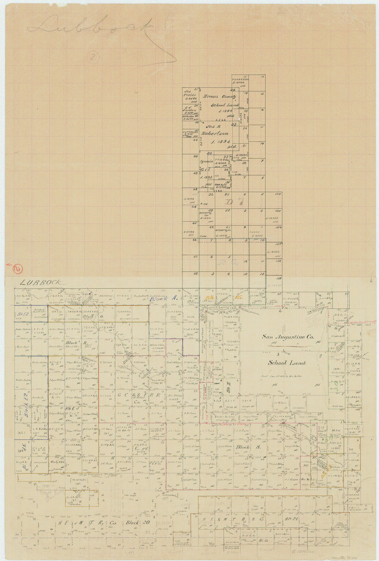
Lubbock County Working Sketch 2
-
Map/Doc
70661
-
Collection
General Map Collection
-
Counties
Lubbock
-
Subjects
Surveying Working Sketch
-
Height x Width
31.7 x 21.4 inches
80.5 x 54.4 cm
-
Comments
To view draftsman's statement on verso, please click the "Download PDF" link above.
Part of: General Map Collection
Matagorda Light to Aransas Pass

Print $20.00
- Digital $50.00
Matagorda Light to Aransas Pass
1962
Size 35.7 x 44.8 inches
Map/Doc 73397
Flight Mission No. CRE-3R, Frame 40, Jackson County

Print $20.00
- Digital $50.00
Flight Mission No. CRE-3R, Frame 40, Jackson County
1956
Size 18.6 x 22.3 inches
Map/Doc 85387
Travis County State Real Property Sketch 6

Print $40.00
- Digital $50.00
Travis County State Real Property Sketch 6
1987
Size 30.2 x 41.4 inches
Map/Doc 61697
Map of Hall County

Print $20.00
- Digital $50.00
Map of Hall County
1895
Size 25.2 x 20.2 inches
Map/Doc 3619
Nueces County Rolled Sketch 107

Print $56.00
Nueces County Rolled Sketch 107
1987
Size 18.4 x 24.8 inches
Map/Doc 7104
A plat representing the survey and resubdivision of four tracts of land known as tracts no. 27, no. 26, no. 23, and no. 22, all of which are part of the Tara Subdivision, an unrecorded subdivision of 263.28 acres out of the J. M. Speer Subdivision

Print $6.00
- Digital $50.00
A plat representing the survey and resubdivision of four tracts of land known as tracts no. 27, no. 26, no. 23, and no. 22, all of which are part of the Tara Subdivision, an unrecorded subdivision of 263.28 acres out of the J. M. Speer Subdivision
1991
Size 24.7 x 34.3 inches
Map/Doc 3112
Jasper County Working Sketch 9

Print $20.00
- Digital $50.00
Jasper County Working Sketch 9
1917
Size 21.0 x 14.3 inches
Map/Doc 66471
Gregg County Boundary File 6

Print $6.00
- Digital $50.00
Gregg County Boundary File 6
Size 8.5 x 5.8 inches
Map/Doc 54001
Hardeman County Sketch File 15

Print $20.00
- Digital $50.00
Hardeman County Sketch File 15
Size 18.9 x 17.9 inches
Map/Doc 11627
[Galveston, Harrisburg & San Antonio from El Paso to El Paso-Presidio county boundary]
![64719, [Galveston, Harrisburg & San Antonio from El Paso to El Paso-Presidio county boundary], General Map Collection](https://historictexasmaps.com/wmedia_w700/maps/64719.tif.jpg)
Print $40.00
- Digital $50.00
[Galveston, Harrisburg & San Antonio from El Paso to El Paso-Presidio county boundary]
Size 150.0 x 27.3 inches
Map/Doc 64719
Galveston County Sketch File 65

Print $70.00
- Digital $50.00
Galveston County Sketch File 65
1892
Size 8.7 x 5.8 inches
Map/Doc 23717
Clay County Boundary File 18

Print $12.00
- Digital $50.00
Clay County Boundary File 18
Size 14.2 x 8.5 inches
Map/Doc 51437
You may also like
[Galveston, Harrisburg & San Antonio Railroad from Cuero to Stockdale]
![64193, [Galveston, Harrisburg & San Antonio Railroad from Cuero to Stockdale], General Map Collection](https://historictexasmaps.com/wmedia_w700/maps/64193.tif.jpg)
Print $20.00
- Digital $50.00
[Galveston, Harrisburg & San Antonio Railroad from Cuero to Stockdale]
1907
Size 13.7 x 34.0 inches
Map/Doc 64193
Surveys in Greer Co.

Print $20.00
- Digital $50.00
Surveys in Greer Co.
Size 16.6 x 14.4 inches
Map/Doc 557
Bell County Sketch File 15

Print $4.00
- Digital $50.00
Bell County Sketch File 15
1861
Size 6.4 x 8.0 inches
Map/Doc 14394
Erath County Sketch File 4

Print $8.00
- Digital $50.00
Erath County Sketch File 4
1853
Size 13.1 x 8.3 inches
Map/Doc 22259
Yates Pool, Pecos County, Texas

Print $3.00
- Digital $50.00
Yates Pool, Pecos County, Texas
1928
Size 11.5 x 10.3 inches
Map/Doc 91674
Mason County Boundary File 63

Print $10.00
- Digital $50.00
Mason County Boundary File 63
Size 9.4 x 5.9 inches
Map/Doc 56879
Edwards County Working Sketch 135

Print $20.00
- Digital $50.00
Edwards County Working Sketch 135
1986
Size 31.8 x 38.4 inches
Map/Doc 69011
Val Verde County Sketch File 53

Print $20.00
- Digital $50.00
Val Verde County Sketch File 53
1892
Size 45.0 x 16.2 inches
Map/Doc 10421
Limestone County Rolled Sketch 4

Print $20.00
- Digital $50.00
Limestone County Rolled Sketch 4
1921
Size 35.1 x 35.1 inches
Map/Doc 9573
[Sketch showing County School Land Leagues]
![90101, [Sketch showing County School Land Leagues], Twichell Survey Records](https://historictexasmaps.com/wmedia_w700/maps/90101-1.tif.jpg)
Print $3.00
- Digital $50.00
[Sketch showing County School Land Leagues]
1902
Size 11.0 x 11.1 inches
Map/Doc 90101
Harris County Sketch File 1

Print $20.00
- Digital $50.00
Harris County Sketch File 1
Size 14.8 x 12.6 inches
Map/Doc 25332
[Map of Burnet County]
![4512, [Map of Burnet County], General Map Collection](https://historictexasmaps.com/wmedia_w700/maps/4512-2.tif.jpg)
Print $20.00
- Digital $50.00
[Map of Burnet County]
1856
Size 26.3 x 23.1 inches
Map/Doc 4512