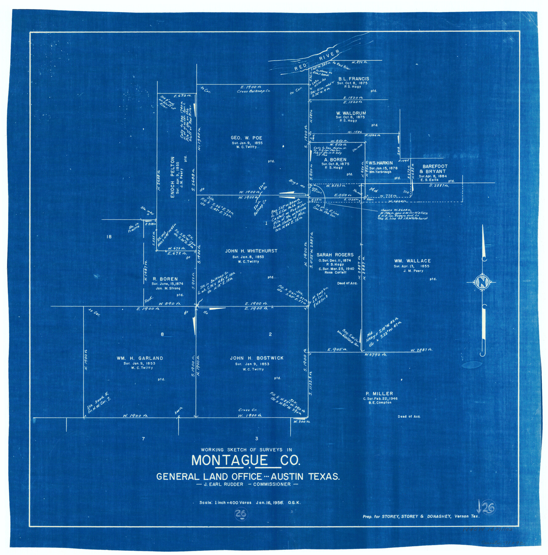
Montague County Working Sketch 26
-
Map/Doc
71092
-
Collection
General Map Collection
-
Object Dates
1/16/1956 (Creation Date)
-
People and Organizations
Otto G. Kurio (Draftsman)
-
Counties
Montague
-
Subjects
Surveying Working Sketch
-
Height x Width
23.5 x 23.2 inches
59.7 x 58.9 cm
-
Scale
1" = 400 varas
Part of: General Map Collection
Uvalde County Working Sketch 43

Print $20.00
- Digital $50.00
Uvalde County Working Sketch 43
1978
Size 29.3 x 27.7 inches
Map/Doc 72113

Burleson County Working Sketch 29

Print $20.00
- Digital $50.00
Burleson County Working Sketch 29
1981
Size 24.7 x 24.7 inches
Map/Doc 67748
Copy of Surveyor's Field Book, Morris Browning - In Blocks 7, 5 & 4, I&GNRRCo., Hutchinson and Carson Counties, Texas

Print $2.00
- Digital $50.00
Copy of Surveyor's Field Book, Morris Browning - In Blocks 7, 5 & 4, I&GNRRCo., Hutchinson and Carson Counties, Texas
1888
Size 6.9 x 8.8 inches
Map/Doc 62260
Duval County Sketch File 19a

Print $40.00
- Digital $50.00
Duval County Sketch File 19a
1880
Size 12.7 x 14.2 inches
Map/Doc 21318
Webb County Working Sketch 96

Print $20.00
- Digital $50.00
Webb County Working Sketch 96
1994
Size 36.1 x 36.3 inches
Map/Doc 72463
Pecos County Working Sketch 60

Print $20.00
- Digital $50.00
Pecos County Working Sketch 60
1950
Size 37.0 x 29.5 inches
Map/Doc 71532
Taylor County Sketch File 5

Print $4.00
- Digital $50.00
Taylor County Sketch File 5
Size 9.3 x 7.8 inches
Map/Doc 37781
Flight Mission No. DQN-1K, Frame 69, Calhoun County

Print $20.00
- Digital $50.00
Flight Mission No. DQN-1K, Frame 69, Calhoun County
1953
Size 18.5 x 22.2 inches
Map/Doc 84156
Flight Mission No. CRE-1R, Frame 194, Jackson County

Print $20.00
- Digital $50.00
Flight Mission No. CRE-1R, Frame 194, Jackson County
1956
Size 18.5 x 22.3 inches
Map/Doc 85348
Burnet County Sketch File 19

Print $4.00
- Digital $50.00
Burnet County Sketch File 19
1859
Size 11.6 x 8.2 inches
Map/Doc 16710
Cochran County Boundary File 7

Print $6.00
- Digital $50.00
Cochran County Boundary File 7
Size 14.0 x 9.1 inches
Map/Doc 51567
You may also like
Orange County Working Sketch 39

Print $20.00
- Digital $50.00
Orange County Working Sketch 39
1966
Size 20.5 x 27.8 inches
Map/Doc 71371
Denton County Sketch File C

Print $10.00
- Digital $50.00
Denton County Sketch File C
1882
Size 10.9 x 8.3 inches
Map/Doc 20682
Rusk County Working Sketch 23

Print $20.00
- Digital $50.00
Rusk County Working Sketch 23
1949
Size 23.9 x 26.5 inches
Map/Doc 63659
Reeves County Sketch File 10

Print $20.00
- Digital $50.00
Reeves County Sketch File 10
Size 17.0 x 32.0 inches
Map/Doc 12244
Flight Mission No. BRA-7M, Frame 192, Jefferson County

Print $20.00
- Digital $50.00
Flight Mission No. BRA-7M, Frame 192, Jefferson County
1953
Size 18.5 x 22.4 inches
Map/Doc 85560
The Texas and Oklahoma Official Railway & Hotel Guide Map

Print $20.00
- Digital $50.00
The Texas and Oklahoma Official Railway & Hotel Guide Map
1906
Size 23.4 x 23.7 inches
Map/Doc 95892
Flight Mission No. CRK-3P, Frame 127, Refugio County

Print $20.00
- Digital $50.00
Flight Mission No. CRK-3P, Frame 127, Refugio County
1956
Size 18.6 x 22.3 inches
Map/Doc 86915
Reeves County Working Sketch 4a

Print $20.00
- Digital $50.00
Reeves County Working Sketch 4a
1933
Size 26.0 x 34.6 inches
Map/Doc 63447
Maverick County Sketch File 21

Print $32.00
- Digital $50.00
Maverick County Sketch File 21
Size 12.6 x 8.1 inches
Map/Doc 31130
Taylor County Sketch File 22

Print $189.00
- Digital $50.00
Taylor County Sketch File 22
1985
Size 14.6 x 8.9 inches
Map/Doc 37826
Hunt County Rolled Sketch 5

Print $20.00
- Digital $50.00
Hunt County Rolled Sketch 5
1956
Size 27.5 x 24.3 inches
Map/Doc 6269
Hudspeth County Working Sketch 15

Print $20.00
- Digital $50.00
Hudspeth County Working Sketch 15
1954
Size 36.4 x 16.2 inches
Map/Doc 66297