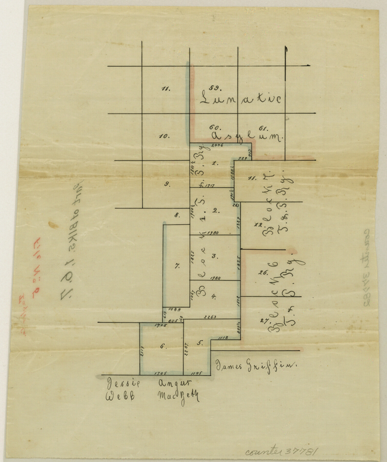
Taylor County Sketch File 5
[Sketch of parts of Blocks 1, 6, and 7 south of Abilene]
-
Map/Doc
37781
-
Collection
General Map Collection
-
Counties
Taylor
-
Subjects
Surveying Sketch File
-
Height x Width
9.3 x 7.8 inches
23.6 x 19.8 cm
-
Medium
paper, manuscript
Part of: General Map Collection
[Map of the Stockdale-Cuero Extension G.H. & S.A. Ry.]
![64096, [Map of the Stockdale-Cuero Extension G.H. & S.A. Ry.], General Map Collection](https://historictexasmaps.com/wmedia_w700/maps/64096.tif.jpg)
Print $40.00
- Digital $50.00
[Map of the Stockdale-Cuero Extension G.H. & S.A. Ry.]
1905
Size 19.4 x 118.2 inches
Map/Doc 64096
Cameron County Rolled Sketch 25

Print $20.00
- Digital $50.00
Cameron County Rolled Sketch 25
1977
Size 24.5 x 30.4 inches
Map/Doc 5793
Grimes County Working Sketch Graphic Index

Print $40.00
- Digital $50.00
Grimes County Working Sketch Graphic Index
1922
Size 54.9 x 29.4 inches
Map/Doc 76560
Map of the Fair Grounds Addition showing subdivisions of Out-lots 39, 49, 50 & 60, Division "O" in the City of Austin

Print $20.00
- Digital $50.00
Map of the Fair Grounds Addition showing subdivisions of Out-lots 39, 49, 50 & 60, Division "O" in the City of Austin
1909
Size 21.4 x 13.3 inches
Map/Doc 2022
Bell County Sketch File 5

Print $4.00
- Digital $50.00
Bell County Sketch File 5
1849
Size 12.9 x 8.5 inches
Map/Doc 14371
Dickens County Sketch File 18aa

Print $20.00
- Digital $50.00
Dickens County Sketch File 18aa
Size 17.2 x 18.2 inches
Map/Doc 11323
Upton County Rolled Sketch 42

Print $40.00
- Digital $50.00
Upton County Rolled Sketch 42
Size 26.5 x 55.9 inches
Map/Doc 10056

Live Oak County Working Sketch 23

Print $40.00
- Digital $50.00
Live Oak County Working Sketch 23
1976
Size 68.2 x 43.5 inches
Map/Doc 70608
Coke County Rolled Sketch 19A

Print $20.00
- Digital $50.00
Coke County Rolled Sketch 19A
1954
Size 19.9 x 24.8 inches
Map/Doc 5520
Parker County Working Sketch 16

Print $20.00
- Digital $50.00
Parker County Working Sketch 16
1990
Map/Doc 71466
PSL Field Notes for Blocks 110 through 122 in Culberson County and Block 123 in Hudspeth County

PSL Field Notes for Blocks 110 through 122 in Culberson County and Block 123 in Hudspeth County
Map/Doc 81666
You may also like
Harris County Rolled Sketch 60

Print $20.00
- Digital $50.00
Harris County Rolled Sketch 60
1927
Size 27.4 x 21.3 inches
Map/Doc 6106
Lampasas County Sketch File 3

Print $4.00
- Digital $50.00
Lampasas County Sketch File 3
1856
Size 12.1 x 7.6 inches
Map/Doc 29392
Chambers County Sketch File 27

Print $12.00
- Digital $50.00
Chambers County Sketch File 27
1934
Size 11.3 x 8.8 inches
Map/Doc 17606
Block G, Section 160, Gaines County, Texas

Print $20.00
- Digital $50.00
Block G, Section 160, Gaines County, Texas
Size 19.7 x 24.0 inches
Map/Doc 92649
[Pecos and Northern Texas Ry., Bailey Co., from Parmer Co. line through Lariat and Muleshoe to Lamb Co. line]
![64636, [Pecos and Northern Texas Ry., Bailey Co., from Parmer Co. line through Lariat and Muleshoe to Lamb Co. line], General Map Collection](https://historictexasmaps.com/wmedia_w700/maps/64636.tif.jpg)
Print $40.00
- Digital $50.00
[Pecos and Northern Texas Ry., Bailey Co., from Parmer Co. line through Lariat and Muleshoe to Lamb Co. line]
1912
Size 20.3 x 121.9 inches
Map/Doc 64636
[Corpus Christi Bay, Padre Island, Mustang Island, Laguna de la Madre, King and Kenedy's Pasture]
![73043, [Corpus Christi Bay, Padre Island, Mustang Island, Laguna de la Madre, King and Kenedy's Pasture], General Map Collection](https://historictexasmaps.com/wmedia_w700/maps/73043.tif.jpg)
Print $20.00
- Digital $50.00
[Corpus Christi Bay, Padre Island, Mustang Island, Laguna de la Madre, King and Kenedy's Pasture]
Size 27.0 x 18.2 inches
Map/Doc 73043
[Location Survey of the Southern Kansas Railway, Kiowa Extension from a point in Drake's Location, in Indian Territory 100 miles from south line of Kansas, continuing up Wolf Creek and South Canadian River to Cottonwood Creek in Hutchinson County]
![88845, [Location Survey of the Southern Kansas Railway, Kiowa Extension from a point in Drake's Location, in Indian Territory 100 miles from south line of Kansas, continuing up Wolf Creek and South Canadian River to Cottonwood Creek in Hutchinson County], General Map Collection](https://historictexasmaps.com/wmedia_w700/maps/88845.tif.jpg)
Print $20.00
- Digital $50.00
[Location Survey of the Southern Kansas Railway, Kiowa Extension from a point in Drake's Location, in Indian Territory 100 miles from south line of Kansas, continuing up Wolf Creek and South Canadian River to Cottonwood Creek in Hutchinson County]
1886
Size 37.5 x 36.0 inches
Map/Doc 88845
Hale County Sketch File 9

Print $14.00
- Digital $50.00
Hale County Sketch File 9
1893
Size 6.1 x 2.6 inches
Map/Doc 24730
Young County Rolled Sketch 5

Print $20.00
- Digital $50.00
Young County Rolled Sketch 5
Size 20.2 x 26.1 inches
Map/Doc 8293
[I. & G. N. Block 1]
![91572, [I. & G. N. Block 1], Twichell Survey Records](https://historictexasmaps.com/wmedia_w700/maps/91572-1.tif.jpg)
Print $20.00
- Digital $50.00
[I. & G. N. Block 1]
Size 17.5 x 13.6 inches
Map/Doc 91572
![88940, Fisher Co[unty], Library of Congress](https://historictexasmaps.com/wmedia_w700/maps/88940.tif.jpg)
Cooke County Sketch File 28

Print $4.00
- Digital $50.00
Cooke County Sketch File 28
1872
Size 12.8 x 8.5 inches
Map/Doc 19281