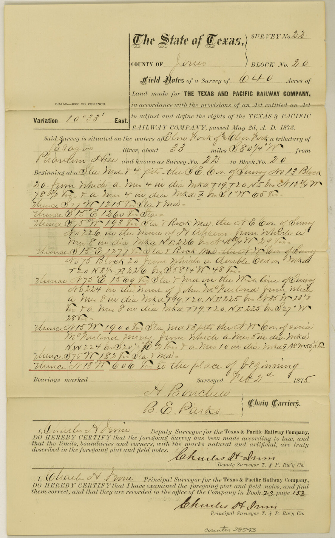
Jones County Sketch File 20
[Field notes of T. & P. RR. Co. survey 22, Block 20]
-
Map/Doc
28543
-
Collection
General Map Collection
-
Object Dates
2/2/1875 (Creation Date)
2/6/1985 (File Date)
2/2/1875 (Survey Date)
-
People and Organizations
Charles H. Irvin (Surveyor/Engineer)
-
Counties
Jones
-
Subjects
Surveying Sketch File
-
Height x Width
14.2 x 8.8 inches
36.1 x 22.4 cm
-
Medium
paper, print with manuscript additions
-
Features
Elm Fork of Clear Fork of Brazos River
Part of: General Map Collection
Hemphill County Sketch File 6

Print $8.00
- Digital $50.00
Hemphill County Sketch File 6
1902
Size 14.2 x 8.6 inches
Map/Doc 26299
Dallam County Working Sketch 5

Print $20.00
- Digital $50.00
Dallam County Working Sketch 5
1990
Size 39.0 x 33.1 inches
Map/Doc 68590
Brewster County Rolled Sketch 93

Print $20.00
- Digital $50.00
Brewster County Rolled Sketch 93
1935
Size 24.1 x 43.1 inches
Map/Doc 5251
Terrell County Working Sketch 25

Print $40.00
- Digital $50.00
Terrell County Working Sketch 25
1942
Size 41.9 x 49.1 inches
Map/Doc 62175
Map of Kinney County

Print $20.00
- Digital $50.00
Map of Kinney County
1876
Size 24.0 x 32.4 inches
Map/Doc 3775
Erath County Sketch File 34

Print $12.00
- Digital $50.00
Erath County Sketch File 34
1989
Size 14.3 x 8.9 inches
Map/Doc 22320
Henderson County Working Sketch 18

Print $20.00
- Digital $50.00
Henderson County Working Sketch 18
1941
Size 23.8 x 23.4 inches
Map/Doc 66151
Lee County Sketch File 2

Print $4.00
- Digital $50.00
Lee County Sketch File 2
Size 12.7 x 8.3 inches
Map/Doc 29680
University Lands Blocks 38 to 57, Crockett-Reagan-Irion-Schleicher-Counties

Print $40.00
- Digital $50.00
University Lands Blocks 38 to 57, Crockett-Reagan-Irion-Schleicher-Counties
1937
Size 34.2 x 52.7 inches
Map/Doc 2444
Loving County Rolled Sketch 3

Print $40.00
- Digital $50.00
Loving County Rolled Sketch 3
Size 13.9 x 145.3 inches
Map/Doc 9464
Nueces County Sketch File 70

Print $8.00
- Digital $50.00
Nueces County Sketch File 70
Size 11.2 x 8.6 inches
Map/Doc 33007
Hardin County Rolled Sketch 16

Print $39.00
- Digital $50.00
Hardin County Rolled Sketch 16
1940
Size 9.9 x 15.9 inches
Map/Doc 45750
You may also like
La Salle County Sketch File 26

Print $4.00
- Digital $50.00
La Salle County Sketch File 26
Size 12.5 x 8.0 inches
Map/Doc 29551
Flight Mission No. DQN-7K, Frame 13, Calhoun County

Print $20.00
- Digital $50.00
Flight Mission No. DQN-7K, Frame 13, Calhoun County
1953
Size 18.4 x 22.1 inches
Map/Doc 84464
Map of the Passo Cavallo on the entrance into Matagorda Bay from the Gulf of Mexico

Print $20.00
- Digital $50.00
Map of the Passo Cavallo on the entrance into Matagorda Bay from the Gulf of Mexico
1853
Size 17.8 x 27.3 inches
Map/Doc 73012
Motley County Sketch File 19 (N)

Print $24.00
- Digital $50.00
Motley County Sketch File 19 (N)
1940
Size 14.2 x 8.8 inches
Map/Doc 32064

[Leagues 70, 71, 72, 73, 74, 75, 704, 705, 718, 719, and 732]
![91099, [Leagues 70, 71, 72, 73, 74, 75, 704, 705, 718, 719, and 732], Twichell Survey Records](https://historictexasmaps.com/wmedia_w700/maps/91099-1.tif.jpg)
Print $2.00
- Digital $50.00
[Leagues 70, 71, 72, 73, 74, 75, 704, 705, 718, 719, and 732]
Size 6.7 x 12.1 inches
Map/Doc 91099
Rusk County Sketch File 33

Print $10.00
Rusk County Sketch File 33
1949
Size 11.5 x 8.8 inches
Map/Doc 35568
Scurry County Working Sketch 9

Print $20.00
- Digital $50.00
Scurry County Working Sketch 9
1982
Size 37.8 x 43.5 inches
Map/Doc 63838
The Republic County of Bexar. December 29, 1845

Print $20.00
The Republic County of Bexar. December 29, 1845
2020
Size 24.6 x 21.6 inches
Map/Doc 96101
[Block B9 and 3KA]
![90329, [Block B9 and 3KA], Twichell Survey Records](https://historictexasmaps.com/wmedia_w700/maps/90329-1.tif.jpg)
Print $20.00
- Digital $50.00
[Block B9 and 3KA]
Size 31.4 x 17.8 inches
Map/Doc 90329
Portion of Pecos County

Print $20.00
- Digital $50.00
Portion of Pecos County
Size 18.8 x 21.6 inches
Map/Doc 91589
Map of Wood County

Print $20.00
- Digital $50.00
Map of Wood County
1857
Size 22.5 x 29.1 inches
Map/Doc 4165