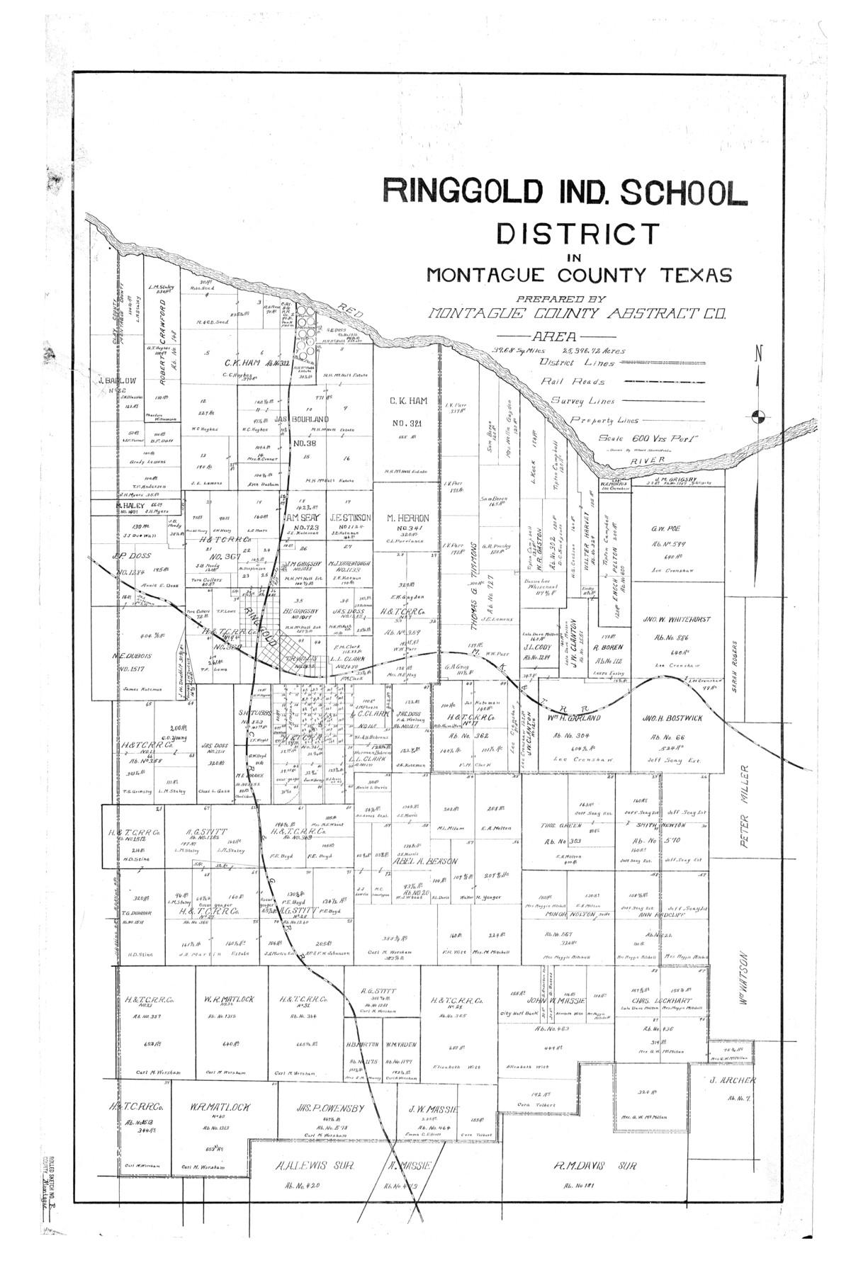
Montague County Rolled Sketch R
Ringgold Ind. School District in Montague County, Texas
-
Map/Doc
6794
-
Collection
General Map Collection
-
People and Organizations
Willard Shackelford (Draftsman)
-
Counties
Montague
-
Subjects
Surveying Rolled Sketch
-
Height x Width
44.3 x 29.8 inches
112.5 x 75.7 cm
-
Scale
1" = 600 varas
Part of: General Map Collection
Map of the United States with its territories: also Mexico and the West Indies

Print $20.00
- Digital $50.00
Map of the United States with its territories: also Mexico and the West Indies
1851
Size 40.1 x 36.7 inches
Map/Doc 93925
Flight Mission No. BQR-5K, Frame 62, Brazoria County

Print $20.00
- Digital $50.00
Flight Mission No. BQR-5K, Frame 62, Brazoria County
1952
Size 18.9 x 22.6 inches
Map/Doc 84007
Terrell County Working Sketch 38

Print $40.00
- Digital $50.00
Terrell County Working Sketch 38
1950
Size 89.1 x 24.9 inches
Map/Doc 62131
Terry County Sketch File 20

Print $4.00
- Digital $50.00
Terry County Sketch File 20
2001
Size 11.1 x 8.8 inches
Map/Doc 76365
Donley County Sketch File 7

Print $20.00
- Digital $50.00
Donley County Sketch File 7
Size 38.3 x 38.2 inches
Map/Doc 10367
Pecos County Working Sketch 16

Print $20.00
- Digital $50.00
Pecos County Working Sketch 16
1915
Size 23.6 x 17.0 inches
Map/Doc 71486
Foard County Rolled Sketch 12

Print $20.00
- Digital $50.00
Foard County Rolled Sketch 12
1945
Size 26.8 x 19.7 inches
Map/Doc 5886
Tyler County Working Sketch 2

Print $20.00
- Digital $50.00
Tyler County Working Sketch 2
1915
Size 17.5 x 10.4 inches
Map/Doc 69472
El Paso County Rolled Sketch 61

Print $20.00
- Digital $50.00
El Paso County Rolled Sketch 61
1994
Size 27.8 x 39.0 inches
Map/Doc 5853
Coke County Sketch File 15

Print $12.00
- Digital $50.00
Coke County Sketch File 15
1893
Size 5.6 x 8.6 inches
Map/Doc 18600
Mason County Working Sketch 8

Print $20.00
- Digital $50.00
Mason County Working Sketch 8
1946
Size 22.9 x 32.3 inches
Map/Doc 70844
Hartley County Sketch File 10

Print $57.00
- Digital $50.00
Hartley County Sketch File 10
Size 9.2 x 7.8 inches
Map/Doc 26099
You may also like
[E. L. & R. R. RR. Blk. 32 and Blk.10 in Northwest corner of County]
![90124, [E. L. & R. R. RR. Blk. 32 and Blk.10 in Northwest corner of County], Twichell Survey Records](https://historictexasmaps.com/wmedia_w700/maps/90124-1.tif.jpg)
Print $2.00
- Digital $50.00
[E. L. & R. R. RR. Blk. 32 and Blk.10 in Northwest corner of County]
Size 14.2 x 8.7 inches
Map/Doc 90124
Real County Working Sketch 15

Print $20.00
- Digital $50.00
Real County Working Sketch 15
1940
Size 17.7 x 22.3 inches
Map/Doc 71907
Hill County Rolled Sketch 1

Print $20.00
- Digital $50.00
Hill County Rolled Sketch 1
1950
Size 13.1 x 41.0 inches
Map/Doc 6214
Tarrant County Working Sketch 22

Print $20.00
- Digital $50.00
Tarrant County Working Sketch 22
2001
Size 27.5 x 23.0 inches
Map/Doc 62439
Jones County Sketch File 6

Print $2.00
- Digital $50.00
Jones County Sketch File 6
1873
Size 8.3 x 11.8 inches
Map/Doc 28494
Stonewall County Rolled Sketch 14

Print $20.00
- Digital $50.00
Stonewall County Rolled Sketch 14
1902
Size 32.9 x 25.2 inches
Map/Doc 7869
Clay County Sketch File 14

Print $40.00
- Digital $50.00
Clay County Sketch File 14
1873
Size 16.5 x 13.8 inches
Map/Doc 18417
Map of the Military Department of the Gulf

Print $20.00
Map of the Military Department of the Gulf
1864
Size 24.4 x 45.7 inches
Map/Doc 93568
General Land Office and State Reclamation Department - An Index Map

Print $20.00
- Digital $50.00
General Land Office and State Reclamation Department - An Index Map
1930
Size 25.8 x 16.4 inches
Map/Doc 3027
East Part of Edwards County

Print $20.00
- Digital $50.00
East Part of Edwards County
1975
Size 39.7 x 28.5 inches
Map/Doc 77270
Map of Harris District

Print $20.00
- Digital $50.00
Map of Harris District
1847
Size 25.4 x 34.4 inches
Map/Doc 1680
Hays County Working Sketch 3

Print $20.00
- Digital $50.00
Hays County Working Sketch 3
1925
Size 28.2 x 24.1 inches
Map/Doc 66077