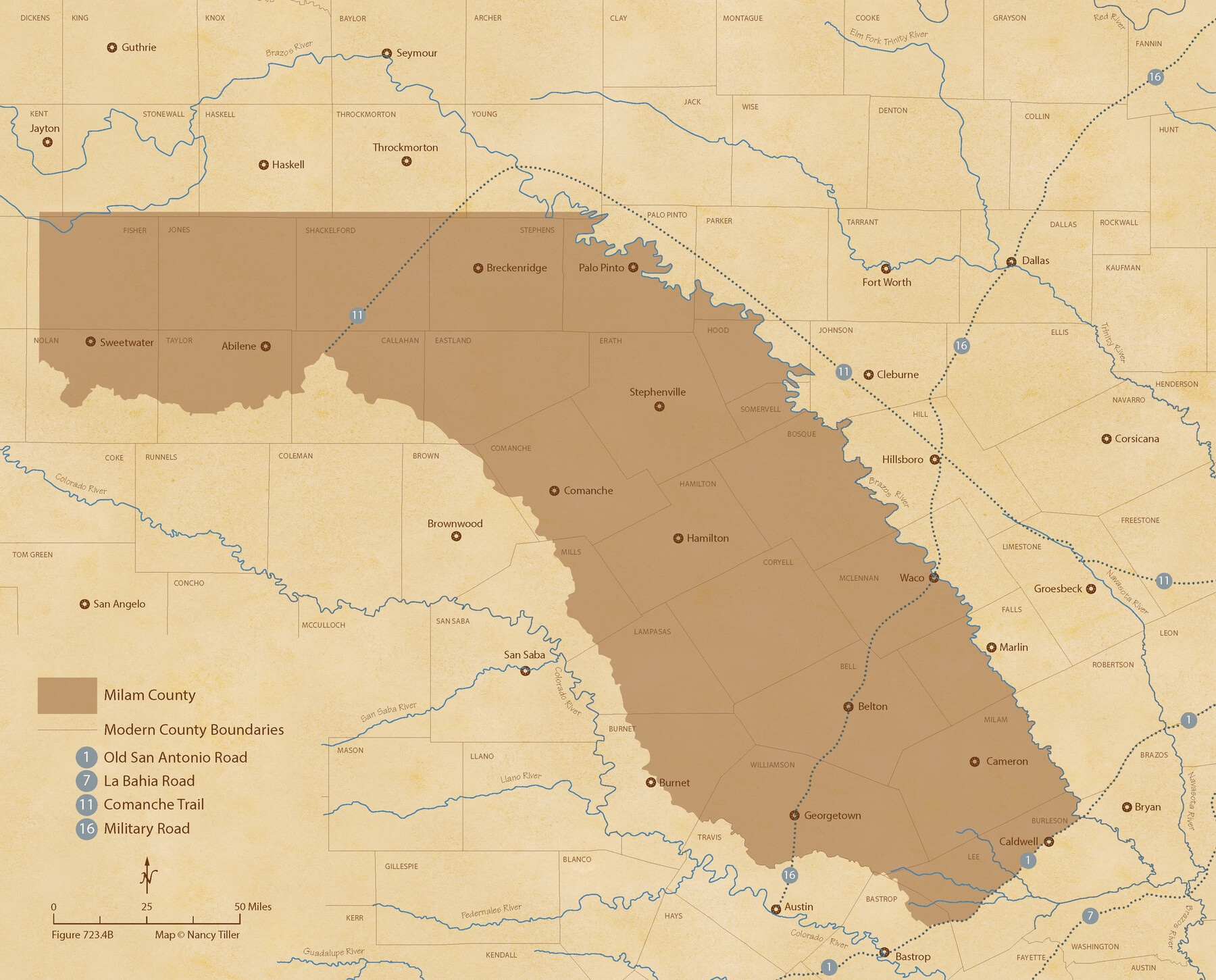
The Republic County of Milam. November 28, 1839
Figure No. 723.4 from 'A Boundary Atlas of Texas, 1821-1845' by Jim Tiller
-
Map/Doc
96228
-
Collection
Nancy and Jim Tiller Digital Collection
-
Object Dates
2020/1/1 (Creation Date)
-
People and Organizations
Jim Tiller (Author)
Nancy Tiller (Cartographer)
Gang Gong (GIS Professional)
-
Counties
Milam
-
Subjects
Atlas County Republic of Texas Texas Boundaries
-
Height x Width
17.4 x 21.6 inches
44.2 x 54.9 cm
-
Medium
digital image
-
Comments
To purchase a digital PDF copy of "A Boundary Atlas of Texas, 1821-1845" see 96437.
Part of: Nancy and Jim Tiller Digital Collection
The Republic County of Washington. December 29, 1845

Print $20.00
The Republic County of Washington. December 29, 1845
2020
Size 11.8 x 21.7 inches
Map/Doc 96310
The Republic County of Fort Bend. Created, December 29, 1837

Print $20.00
The Republic County of Fort Bend. Created, December 29, 1837
2020
Size 14.7 x 21.6 inches
Map/Doc 96137
Vehlein and Company Empresario Colony. November 17, 1828

Print $20.00
Vehlein and Company Empresario Colony. November 17, 1828
2020
Size 20.8 x 21.7 inches
Map/Doc 96008
The Republic County of Washington. January 30, 1841

Print $20.00
The Republic County of Washington. January 30, 1841
2020
Size 20.3 x 21.7 inches
Map/Doc 96305
The Republic County of Matagorda. December 24, 1844

Print $20.00
The Republic County of Matagorda. December 24, 1844
2020
Size 21.0 x 21.7 inches
Map/Doc 96223
The Mexican Municipality of Matagorda. December 5, 1835

Print $20.00
The Mexican Municipality of Matagorda. December 5, 1835
2020
Size 15.9 x 21.7 inches
Map/Doc 96027
The Republic County of Jackson. September 17, 1838

Print $20.00
The Republic County of Jackson. September 17, 1838
2020
Size 15.6 x 21.8 inches
Map/Doc 96185
The Mexican Department of Bexar. May 6, 1833

Print $20.00
The Mexican Department of Bexar. May 6, 1833
2020
Size 16.0 x 21.6 inches
Map/Doc 95969
The Chief Justice County of Mina. Lands in Conflict with Colorado County

Print $20.00
The Chief Justice County of Mina. Lands in Conflict with Colorado County
2020
Size 15.8 x 21.7 inches
Map/Doc 96062
From Citizens of Nacogdoches County for the Creation of a New County (Unnamed), October 1839

Print $20.00
From Citizens of Nacogdoches County for the Creation of a New County (Unnamed), October 1839
2020
Size 18.2 x 21.7 inches
Map/Doc 96386
The Republic County of Brazos. December 29, 1845

Print $20.00
The Republic County of Brazos. December 29, 1845
2020
Size 20.6 x 21.7 inches
Map/Doc 96117
The Republic County of Matagorda. January 1, 1838

Print $20.00
The Republic County of Matagorda. January 1, 1838
2020
Size 21.0 x 21.7 inches
Map/Doc 96216
You may also like
Township 11 South Range 13 West and 14 West, South Western District, Louisiana

Print $20.00
- Digital $50.00
Township 11 South Range 13 West and 14 West, South Western District, Louisiana
1838
Size 19.6 x 24.6 inches
Map/Doc 65854
Bosque County

Print $20.00
- Digital $50.00
Bosque County
1945
Size 42.6 x 33.0 inches
Map/Doc 77215
G. C. & S. F. Ry. Northern-Division, Alignment and Right of Way Map, Weatherford Branch, Johnson and Hood Counties, Texas

Print $40.00
- Digital $50.00
G. C. & S. F. Ry. Northern-Division, Alignment and Right of Way Map, Weatherford Branch, Johnson and Hood Counties, Texas
1935
Size 37.8 x 100.5 inches
Map/Doc 64649
Brazos River, Jones Bridge Special Map Sheet

Print $4.00
- Digital $50.00
Brazos River, Jones Bridge Special Map Sheet
1936
Size 29.8 x 28.2 inches
Map/Doc 65280
Tom Green County Working Sketch 9

Print $20.00
- Digital $50.00
Tom Green County Working Sketch 9
1951
Size 31.3 x 42.2 inches
Map/Doc 69378
Pecos County Rolled Sketch 51

Print $20.00
- Digital $50.00
Pecos County Rolled Sketch 51
1914
Size 8.6 x 35.5 inches
Map/Doc 7227
Matagorda County Sketch File 7b

Print $4.00
- Digital $50.00
Matagorda County Sketch File 7b
1890
Size 14.2 x 8.8 inches
Map/Doc 30744
Parker County Working Sketch 21

Print $20.00
- Digital $50.00
Parker County Working Sketch 21
2006
Map/Doc 83655
Panola County Rolled Sketch 4A

Print $40.00
- Digital $50.00
Panola County Rolled Sketch 4A
1953
Size 50.7 x 26.1 inches
Map/Doc 10727
Real County Working Sketch 68

Print $20.00
- Digital $50.00
Real County Working Sketch 68
1973
Size 21.9 x 24.4 inches
Map/Doc 71960
Galveston County NRC Article 33.136 Sketch 49

Print $24.00
- Digital $50.00
Galveston County NRC Article 33.136 Sketch 49
2007
Size 24.0 x 36.0 inches
Map/Doc 94663
Harris County Working Sketch 49

Print $20.00
- Digital $50.00
Harris County Working Sketch 49
1944
Size 28.7 x 33.9 inches
Map/Doc 65941