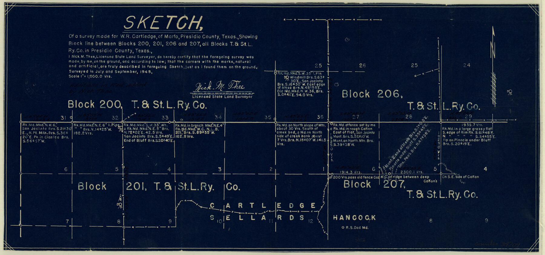
Presidio County Sketch File 80
[Sketch of Blocks 200, 201, 206 and 207, T. & St. L. RR. Co.]
-
Map/Doc
34709
-
Collection
General Map Collection
-
Object Dates
9/1948 (Creation Date)
2/25/1949 (File Date)
7/1948 (Survey Date)
9/1948 (Survey Date)
-
People and Organizations
Nick M. Thee (Surveyor/Engineer)
-
Counties
Presidio
-
Subjects
Surveying Sketch File
-
Height x Width
9.5 x 20.3 inches
24.1 x 51.6 cm
-
Medium
blueprint/diazo
-
Scale
1" = 1000 varas
-
Features
San Jacinto Peak
Part of: General Map Collection
Flight Mission No. BRE-2P, Frame 65, Nueces County

Print $20.00
- Digital $50.00
Flight Mission No. BRE-2P, Frame 65, Nueces County
1956
Size 18.4 x 22.3 inches
Map/Doc 86760
PSL Field Notes for Block C24 in Loving and Winkler Counties, and Blocks C25, C26, and C27 in Loving County

PSL Field Notes for Block C24 in Loving and Winkler Counties, and Blocks C25, C26, and C27 in Loving County
Map/Doc 81680
Austin County Rolled Sketch 5B

Print $40.00
- Digital $50.00
Austin County Rolled Sketch 5B
Size 23.7 x 51.5 inches
Map/Doc 5107
Presidio de San Antonio de Bejar

Presidio de San Antonio de Bejar
2006
Size 10.8 x 16.9 inches
Map/Doc 87385
Jackson County Boundary File 3

Print $10.00
- Digital $50.00
Jackson County Boundary File 3
Size 10.9 x 8.7 inches
Map/Doc 55455
Stonewall County Boundary File 4

Print $32.00
- Digital $50.00
Stonewall County Boundary File 4
Size 14.4 x 9.1 inches
Map/Doc 58977
Survey of the Mexican Lines of Defence at Cerro Gordo, and the lines of attack of the American Army under Major General Scott, on the 17th and 18th of April, 1847

Print $20.00
- Digital $50.00
Survey of the Mexican Lines of Defence at Cerro Gordo, and the lines of attack of the American Army under Major General Scott, on the 17th and 18th of April, 1847
1847
Size 15.3 x 21.6 inches
Map/Doc 95830
Bowie County Sketch File 8d

Print $4.00
- Digital $50.00
Bowie County Sketch File 8d
Size 14.2 x 8.6 inches
Map/Doc 14894
Randall County

Print $20.00
- Digital $50.00
Randall County
1958
Size 41.0 x 33.0 inches
Map/Doc 77402
Stieler Map of 1879

Print $4.00
- Digital $50.00
Stieler Map of 1879
1879
Size 28.8 x 23.0 inches
Map/Doc 76056
Texas, Matagorda Peninsula, Cotton Bayou

Print $6.00
- Digital $50.00
Texas, Matagorda Peninsula, Cotton Bayou
Size 31.5 x 34.6 inches
Map/Doc 69986
Gaines County Rolled Sketch 21

Print $20.00
- Digital $50.00
Gaines County Rolled Sketch 21
Size 29.0 x 24.9 inches
Map/Doc 5937
You may also like
Freestone County Rolled Sketch 12A

Print $40.00
- Digital $50.00
Freestone County Rolled Sketch 12A
1987
Size 35.2 x 48.6 inches
Map/Doc 8897
Dawson County Working Sketch 16

Print $20.00
- Digital $50.00
Dawson County Working Sketch 16
1956
Size 13.9 x 18.8 inches
Map/Doc 68560

Portion of States Submerged Area in Matagorda Bay

Print $20.00
- Digital $50.00
Portion of States Submerged Area in Matagorda Bay
1922
Size 15.2 x 14.8 inches
Map/Doc 2953
Angelina County Sketch File 15c

Print $16.00
- Digital $50.00
Angelina County Sketch File 15c
1838
Size 12.2 x 8.0 inches
Map/Doc 12972


Map of Comal County

Print $20.00
- Digital $50.00
Map of Comal County
1862
Size 18.6 x 22.0 inches
Map/Doc 3429
Fisher County Working Sketch Graphic Index

Print $20.00
- Digital $50.00
Fisher County Working Sketch Graphic Index
1944
Size 46.9 x 41.4 inches
Map/Doc 76542

Brewster County Rolled Sketch 125

Print $179.00
- Digital $50.00
Brewster County Rolled Sketch 125
1889
Map/Doc 43141
Angelina County Working Sketch 1

Print $20.00
- Digital $50.00
Angelina County Working Sketch 1
Size 17.3 x 17.8 inches
Map/Doc 67081