Austin County Rolled Sketch 5B
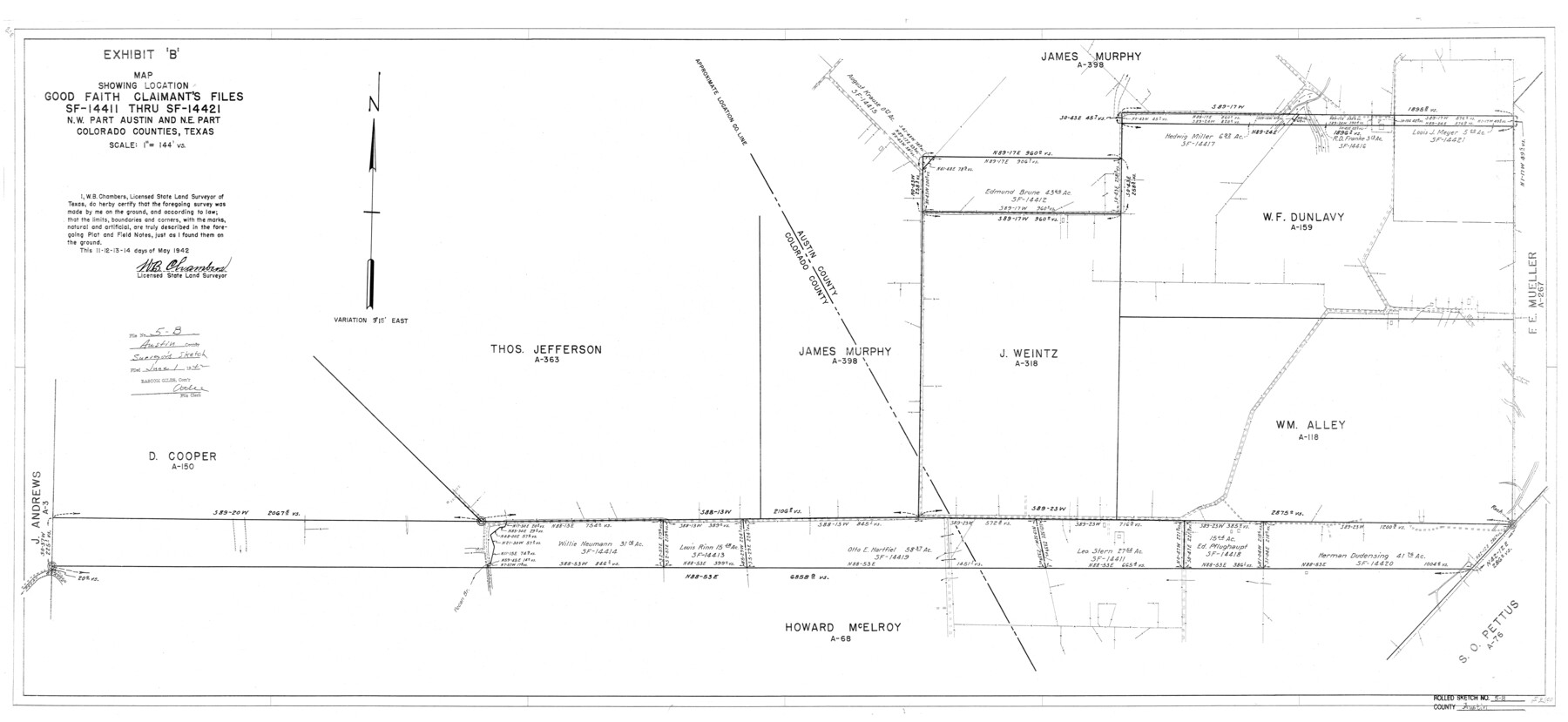
Exhibit 'B' - Map showing location, Good Faith Claimant's files SF-14411 thru SF-14421, N.W. part Austin and N.E. part Colorado Counties, Texas
- 
                          Map/Doc5107
- 
                            CollectionGeneral Map Collection
- 
                            Object Dates1942/5/14 (Survey Date)1942/6/1 (File Date)1942/5/13 (Survey Date)1942/5/12 (Survey Date)1942/5/11 (Survey Date)
- 
                            People and OrganizationsW.B. Chambers (Surveyor/Engineer)
- 
                            CountiesAustin
- 
                            SubjectsSurveying Rolled Sketch
- 
                            Height x Width23.7 x 51.5 inches60.2 x 130.8 cm
- 
                            Mediumblueprint/diazo
- 
                            Scale1" = 144 varas
- 
                            CommentsSee Austin County Rolled Sketch 5A (8437) for related sketch.
Related maps
            Austin County Rolled Sketch 5A


                                            Print $40.00                    
                                             -                         Digital $50.00                                    
                Austin County Rolled Sketch 5A
Size 54.2 x 44.1 inches
                                Map/Doc 8437
            Part of: General Map Collection
            Location of the Southern Kansas Railway of Texas through Hemphill County, Texas


                                            Print $40.00                    
                                             -                         Digital $50.00                                    
                Location of the Southern Kansas Railway of Texas through Hemphill County, Texas
1887
Size 20.2 x 91.8 inches
                                Map/Doc 64000
            
            Flight Mission No. CRC-5R, Frame 35, Chambers County


                                            Print $20.00                    
                                             -                         Digital $50.00                                    
                Flight Mission No. CRC-5R, Frame 35, Chambers County
1956
Size 18.5 x 22.3 inches
                                Map/Doc 84954
            
            Uvalde County Working Sketch 8


                                            Print $20.00                    
                                             -                         Digital $50.00                                    
                Uvalde County Working Sketch 8
1942
Size 37.4 x 23.6 inches
                                Map/Doc 72078
            
            [Gulf, Colorado & Santa Fe]
            
                                    ![64577, [Gulf, Colorado & Santa Fe], General Map Collection](https://historictexasmaps.com/wmedia_w700/maps/64577.tif.jpg) 


    ![64577, [Gulf, Colorado & Santa Fe], General Map Collection](https://historictexasmaps.com/wmedia_w700/maps/64577.tif.jpg) 
                                
            
                                            Print $20.00                    
                                             -                         Digital $50.00                                    
                [Gulf, Colorado & Santa Fe]
Size 32.4 x 47.4 inches
                                Map/Doc 64577
            
            Zavala County


                                            Print $40.00                    
                                             -                         Digital $50.00                                    
                Zavala County
1915
Size 39.6 x 48.3 inches
                                Map/Doc 63147
            
            [Right of Way & Track Map, The Texas & Pacific Ry. Co. Main Line]
            
                                    ![64661, [Right of Way & Track Map, The Texas & Pacific Ry. Co. Main Line], General Map Collection](https://historictexasmaps.com/wmedia_w700/maps/64661.tif.jpg) 


    ![64661, [Right of Way & Track Map, The Texas & Pacific Ry. Co. Main Line], General Map Collection](https://historictexasmaps.com/wmedia_w700/maps/64661.tif.jpg) 
                                
            
                                            Print $20.00                    
                                             -                         Digital $50.00                                    
                [Right of Way & Track Map, The Texas & Pacific Ry. Co. Main Line]
Size 11.0 x 18.6 inches
                                Map/Doc 64661
            
            Houston County Rolled Sketch 6


                                            Print $40.00                    
                                             -                         Digital $50.00                                    
                Houston County Rolled Sketch 6
1963
Size 48.0 x 34.3 inches
                                Map/Doc 9182
            
            Shelby County Rolled Sketch 10


                                            Print $20.00                    
                                             -                         Digital $50.00                                    
                Shelby County Rolled Sketch 10
Size 16.2 x 27.3 inches
                                Map/Doc 7778
            
            El Paso County Working Sketch 27


                                            Print $20.00                    
                                             -                         Digital $50.00                                    
                El Paso County Working Sketch 27
1963
Size 34.2 x 13.2 inches
                                Map/Doc 69049
            
            Henderson County Working Sketch 5


                                            Print $20.00                    
                                             -                         Digital $50.00                                    
                Henderson County Working Sketch 5
1918
Size 19.2 x 23.5 inches
                                Map/Doc 66138
            
            Right of Way and Track Map, The Wichita Falls & Southern Railway


                                            Print $40.00                    
                                             -                         Digital $50.00                                    
                Right of Way and Track Map, The Wichita Falls & Southern Railway
1942
Size 25.0 x 121.0 inches
                                Map/Doc 64512
            
            Flight Mission No. CRC-3R, Frame 165, Chambers County


                                            Print $20.00                    
                                             -                         Digital $50.00                                    
                Flight Mission No. CRC-3R, Frame 165, Chambers County
1956
Size 18.8 x 22.5 inches
                                Map/Doc 84847
            You may also like
            Sabine Pass and mouth of the River Sabine in the sea


                                            Print $20.00                    
                                             -                         Digital $50.00                                    
                Sabine Pass and mouth of the River Sabine in the sea
1840
Size 23.8 x 19.0 inches
                                Map/Doc 94268
            
            North East Corner of Lamar County


                                            Print $3.00                    
                                             -                         Digital $50.00                                    
                North East Corner of Lamar County
Size 10.7 x 15.4 inches
                                Map/Doc 291
            
            Crosby County Sketch File 15a


                                            Print $20.00                    
                                             -                         Digital $50.00                                    
                Crosby County Sketch File 15a
1907
Size 37.6 x 41.1 inches
                                Map/Doc 10352
            
            [Texas Department of Corrections Prison Farm Locations]
            
                                    ![78638, [Texas Department of Corrections Prison Farm Locations], General Map Collection](https://historictexasmaps.com/wmedia_w700/maps/78638.tif.jpg) 


    ![78638, [Texas Department of Corrections Prison Farm Locations], General Map Collection](https://historictexasmaps.com/wmedia_w700/maps/78638.tif.jpg) 
                                
            
                                            Print $40.00                    
                                             -                         Digital $50.00                                    
                [Texas Department of Corrections Prison Farm Locations]
Size 43.0 x 54.0 inches
                                Map/Doc 78638
            
            Val Verde County Rolled Sketch 3


                                            Print $20.00                    
                                             -                         Digital $50.00                                    
                Val Verde County Rolled Sketch 3
1887
Size 44.8 x 36.5 inches
                                Map/Doc 10070
            
            [Sketch of area south of Runnels County School Land League No. 3]
            
                                    ![91544, [Sketch of area south of Runnels County School Land League No. 3], Twichell Survey Records](https://historictexasmaps.com/wmedia_w700/maps/91544-1.tif.jpg) 


    ![91544, [Sketch of area south of Runnels County School Land League No. 3], Twichell Survey Records](https://historictexasmaps.com/wmedia_w700/maps/91544-1.tif.jpg) 
                                
            
                                            Print $2.00                    
                                             -                         Digital $50.00                                    
                [Sketch of area south of Runnels County School Land League No. 3]
Size 11.9 x 9.2 inches
                                Map/Doc 91544
            
            Llano County Working Sketch 14


                                            Print $20.00                    
                                             -                         Digital $50.00                                    
                Llano County Working Sketch 14
1989
Size 14.6 x 34.7 inches
                                Map/Doc 70632
            
            Nova Totivs Americae Descriptio


                                            Print $20.00                    
                                             -                         Digital $50.00                                    
                Nova Totivs Americae Descriptio
1666
Size 21.2 x 24.3 inches
                                Map/Doc 93818
            
            Map of Coryell County


                                            Print $20.00                    
                                             -                         Digital $50.00                                    
                Map of Coryell County
1855
Size 22.5 x 23.0 inches
                                Map/Doc 3447
            
            Montague County Working Sketch 27


                                            Print $20.00                    
                                             -                         Digital $50.00                                    
                Montague County Working Sketch 27
1956
Size 35.8 x 24.9 inches
                                Map/Doc 71093
            
            Kinney County Working Sketch 19


                                            Print $20.00                    
                                             -                         Digital $50.00                                    
                Kinney County Working Sketch 19
1948
Size 32.0 x 35.7 inches
                                Map/Doc 70201
             
                        