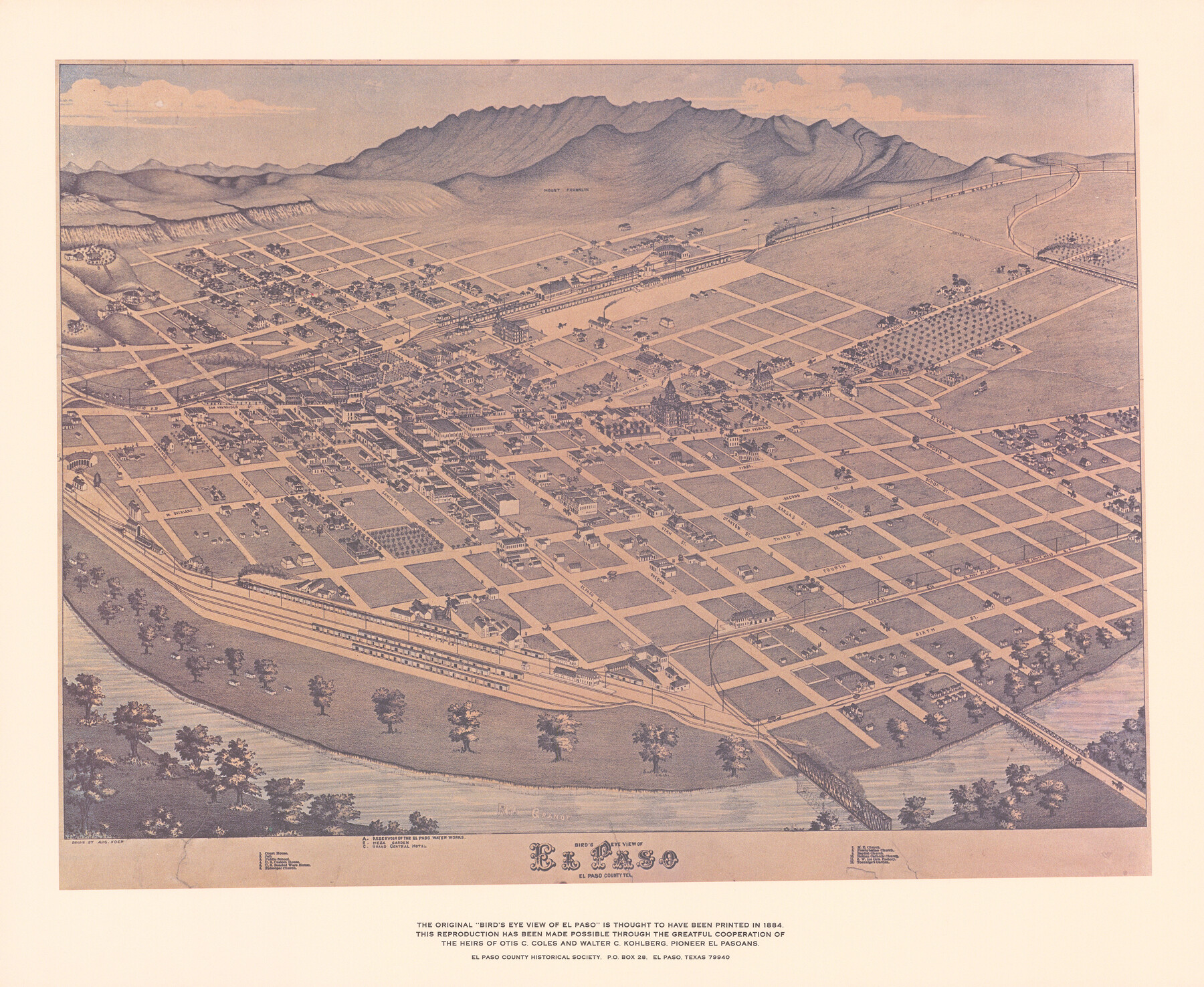
Bird's Eye View of El Paso
[reproduction print]
-
Map/Doc
95405
-
Collection
General Map Collection
-
Object Dates
1884 (Creation Date)
-
People and Organizations
El Paso County Historical Society (Publisher)
Augustus Koch (Draftsman)
-
Counties
El Paso
-
Subjects
Bird's Eye View City
-
Height x Width
19.5 x 23.7 inches
49.5 x 60.2 cm
-
Medium
digital image
-
Comments
Digital image of this reproduction print was provided by the El Paso County Historical Society. Not available for duplication, for research only.
Part of: General Map Collection
Flight Mission No. DAG-22K, Frame 77, Matagorda County

Print $20.00
- Digital $50.00
Flight Mission No. DAG-22K, Frame 77, Matagorda County
1953
Size 18.6 x 22.4 inches
Map/Doc 86464
Garza County Rolled Sketch 5

Print $40.00
- Digital $50.00
Garza County Rolled Sketch 5
1906
Size 37.2 x 48.0 inches
Map/Doc 9050
Roberts County Working Sketch Graphic Index

Print $20.00
- Digital $50.00
Roberts County Working Sketch Graphic Index
1932
Size 41.2 x 37.3 inches
Map/Doc 76684
Limestone County Boundary File 59

Print $34.00
- Digital $50.00
Limestone County Boundary File 59
Size 7.4 x 8.7 inches
Map/Doc 56299
Nueces County Sketch File 46

Print $44.00
- Digital $50.00
Nueces County Sketch File 46
1907
Size 11.1 x 8.7 inches
Map/Doc 32643

Kerr County Working Sketch 18

Print $20.00
- Digital $50.00
Kerr County Working Sketch 18
1956
Size 25.4 x 29.3 inches
Map/Doc 70049
Plat showing proposed counties to be taken from Zapata, Starr & Hidalgo Counties

Print $20.00
- Digital $50.00
Plat showing proposed counties to be taken from Zapata, Starr & Hidalgo Counties
1911
Size 24.8 x 27.8 inches
Map/Doc 2660
Nueces County NRC Article 33.136 Sketch 10

Print $36.00
- Digital $50.00
Nueces County NRC Article 33.136 Sketch 10
2004
Size 23.9 x 35.9 inches
Map/Doc 83526
Flight Mission No. BRA-8M, Frame 119, Jefferson County

Print $20.00
- Digital $50.00
Flight Mission No. BRA-8M, Frame 119, Jefferson County
1953
Size 18.4 x 22.2 inches
Map/Doc 85615
Harbor Pass and Bar at Brazos Santiago, Texas

Print $20.00
- Digital $50.00
Harbor Pass and Bar at Brazos Santiago, Texas
1871
Size 18.4 x 27.4 inches
Map/Doc 73039
New Map of the State of Texas compiled from J. De Cordova's large map

Print $20.00
- Digital $50.00
New Map of the State of Texas compiled from J. De Cordova's large map
1855
Map/Doc 93943
You may also like
Comanche County Working Sketch 20

Print $20.00
- Digital $50.00
Comanche County Working Sketch 20
1973
Size 20.5 x 15.6 inches
Map/Doc 68154
Crane County Rolled Sketch 29

Print $20.00
- Digital $50.00
Crane County Rolled Sketch 29
2024
Size 24.6 x 35.5 inches
Map/Doc 97338
Mason County Sketch File 7

Print $4.00
- Digital $50.00
Mason County Sketch File 7
Size 7.9 x 8.8 inches
Map/Doc 30689
Current Miscellaneous File 52

Print $12.00
- Digital $50.00
Current Miscellaneous File 52
1953
Size 12.3 x 9.3 inches
Map/Doc 74032
Van Zandt County Sketch File 4

Print $6.00
- Digital $50.00
Van Zandt County Sketch File 4
1858
Size 10.7 x 11.1 inches
Map/Doc 39369
Colorado County Sketch File 24

Print $20.00
- Digital $50.00
Colorado County Sketch File 24
Size 22.7 x 16.6 inches
Map/Doc 11137

[Leagues 11 and 22]
![91111, [Leagues 11 and 22], Twichell Survey Records](https://historictexasmaps.com/wmedia_w700/maps/91111-1.tif.jpg)
Print $20.00
- Digital $50.00
[Leagues 11 and 22]
1925
Size 14.0 x 13.6 inches
Map/Doc 91111
Dallas County Boundary File 6a

Print $36.00
- Digital $50.00
Dallas County Boundary File 6a
Size 14.0 x 8.6 inches
Map/Doc 52189
Right of Way and Track Map, the Missouri, Kansas & Texas Ry. Of Texas operated by the Missouri, Kansas & Texas Ry. Of Texas, Houston Division

Print $40.00
- Digital $50.00
Right of Way and Track Map, the Missouri, Kansas & Texas Ry. Of Texas operated by the Missouri, Kansas & Texas Ry. Of Texas, Houston Division
1918
Size 25.6 x 64.4 inches
Map/Doc 64566

Brewster County Rolled Sketch 114

Print $20.00
- Digital $50.00
Brewster County Rolled Sketch 114
1964
Size 12.1 x 18.3 inches
Map/Doc 5285