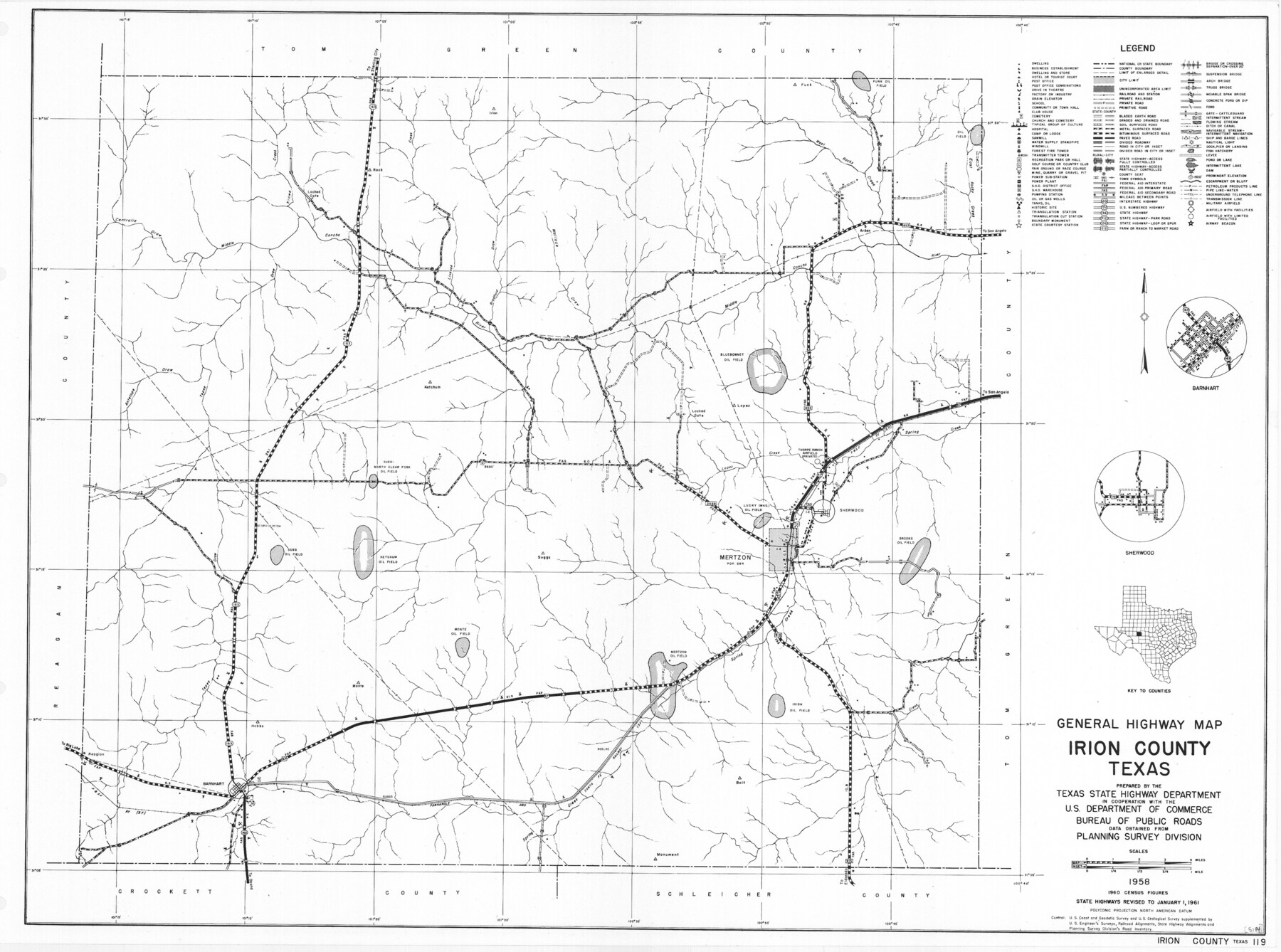
General Highway Map, Irion County, Texas
-
Map/Doc
79531
-
Collection
Texas State Library and Archives
-
Object Dates
1961 (Creation Date)
-
People and Organizations
Texas State Highway Department (Publisher)
-
Counties
Irion
-
Subjects
County
-
Height x Width
18.2 x 24.5 inches
46.2 x 62.2 cm
-
Comments
Prints available courtesy of the Texas State Library and Archives.
More info can be found here: TSLAC Map 05184
Part of: Texas State Library and Archives
General Highway Map, Matagorda County, Texas

Print $20.00
General Highway Map, Matagorda County, Texas
1939
Size 24.7 x 18.3 inches
Map/Doc 79187
General Highway Map. Detail of Cities and Towns in Travis County, Texas

Print $20.00
General Highway Map. Detail of Cities and Towns in Travis County, Texas
1961
Size 18.2 x 24.9 inches
Map/Doc 79681
Best Route for Movements of Troops from Laredo to Ringold [sic] Barracks, Texas
![79299, Best Route for Movements of Troops from Laredo to Ringold [sic] Barracks, Texas, Texas State Library and Archives](https://historictexasmaps.com/wmedia_w700/maps/79299.tif.jpg)
Print $20.00
Best Route for Movements of Troops from Laredo to Ringold [sic] Barracks, Texas
1865
Size 18.9 x 15.3 inches
Map/Doc 79299
General Highway Map, Clay County, Texas

Print $20.00
General Highway Map, Clay County, Texas
1940
Size 25.2 x 18.6 inches
Map/Doc 79047
General Highway Map, Jefferson County, Texas

Print $20.00
General Highway Map, Jefferson County, Texas
1940
Size 24.8 x 18.6 inches
Map/Doc 79144
General Highway Map, Edwards County, Real County, Texas

Print $20.00
General Highway Map, Edwards County, Real County, Texas
1961
Size 18.1 x 24.7 inches
Map/Doc 79452
General Highway Map, Gonzales County, Texas

Print $20.00
General Highway Map, Gonzales County, Texas
1961
Size 18.2 x 24.7 inches
Map/Doc 79482
General Highway Map, DeWitt County, Texas

Print $20.00
General Highway Map, DeWitt County, Texas
1961
Size 18.3 x 24.5 inches
Map/Doc 79442
General Highway Map, Liberty County, Texas

Print $20.00
General Highway Map, Liberty County, Texas
1961
Size 18.1 x 24.6 inches
Map/Doc 79571
General Highway Map, Dimmit County, La Salle County, Texas

Print $20.00
General Highway Map, Dimmit County, La Salle County, Texas
1940
Size 18.4 x 25.2 inches
Map/Doc 79077
General Highway Map. Detail of Cities and Towns in Lubbock County, Texas [Lubbock and vicinity]
![79181, General Highway Map. Detail of Cities and Towns in Lubbock County, Texas [Lubbock and vicinity], Texas State Library and Archives](https://historictexasmaps.com/wmedia_w700/maps/79181.tif.jpg)
Print $20.00
General Highway Map. Detail of Cities and Towns in Lubbock County, Texas [Lubbock and vicinity]
1940
Size 18.3 x 24.8 inches
Map/Doc 79181
General Highway Map, Bandera County, Texas

Print $20.00
General Highway Map, Bandera County, Texas
1940
Size 18.4 x 25.1 inches
Map/Doc 79011
You may also like
Runnels County Working Sketch 20

Print $20.00
- Digital $50.00
Runnels County Working Sketch 20
1950
Size 23.1 x 30.9 inches
Map/Doc 63616
Presidio County Sketch File 87

Print $6.00
- Digital $50.00
Presidio County Sketch File 87
1951
Size 14.5 x 8.7 inches
Map/Doc 34748
Menard County Rolled Sketch 15

Print $20.00
- Digital $50.00
Menard County Rolled Sketch 15
1983
Size 27.9 x 22.0 inches
Map/Doc 6761
Wood County Working Sketch 5

Print $20.00
- Digital $50.00
Wood County Working Sketch 5
1941
Size 27.8 x 38.7 inches
Map/Doc 62005
Wharton County Sketch File 4b

Print $4.00
- Digital $50.00
Wharton County Sketch File 4b
1876
Size 12.7 x 8.0 inches
Map/Doc 39921
Comanche County Sketch File 8

Print $4.00
- Digital $50.00
Comanche County Sketch File 8
1853
Size 13.1 x 8.2 inches
Map/Doc 19066
Menard County Sketch File 19

Print $4.00
- Digital $50.00
Menard County Sketch File 19
1905
Size 11.2 x 8.8 inches
Map/Doc 31546
Navarro County Sketch File 11

Print $4.00
- Digital $50.00
Navarro County Sketch File 11
1859
Size 10.4 x 8.2 inches
Map/Doc 32320
A sketch of the San Antonio River collected from the Land Office surveys

Print $20.00
- Digital $50.00
A sketch of the San Antonio River collected from the Land Office surveys
1853
Size 27.2 x 16.3 inches
Map/Doc 73010
Leon County Working Sketch 26

Print $20.00
- Digital $50.00
Leon County Working Sketch 26
1969
Size 43.1 x 46.9 inches
Map/Doc 70425
Liberty County Working Sketch 77

Print $20.00
- Digital $50.00
Liberty County Working Sketch 77
Size 37.4 x 45.9 inches
Map/Doc 70537
Erath County Rolled Sketch 2A

Print $20.00
- Digital $50.00
Erath County Rolled Sketch 2A
Size 18.8 x 21.4 inches
Map/Doc 5862