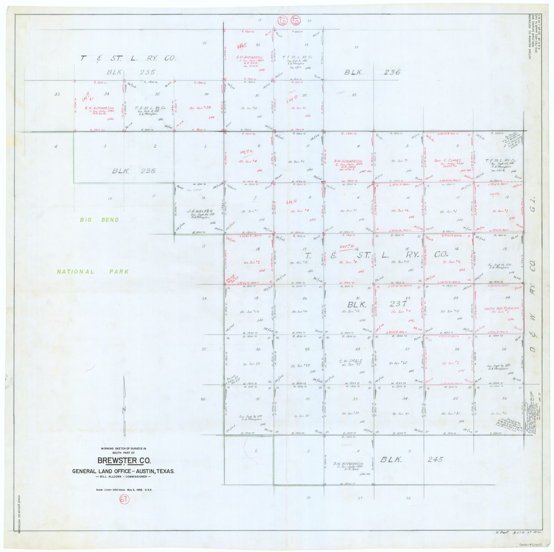
Brewster County Working Sketch 67
-
Map/Doc
67668
-
Collection
General Map Collection
-
Object Dates
5/2/1958 (Creation Date)
-
People and Organizations
Otto G. Kurio (Draftsman)
-
Counties
Brewster
-
Subjects
Surveying Working Sketch
-
Height x Width
41.9 x 42.0 inches
106.4 x 106.7 cm
-
Scale
1" = 500 varas
Part of: General Map Collection
[Surveys on the Rio Frio]
![267, [Surveys on the Rio Frio], General Map Collection](https://historictexasmaps.com/wmedia_w700/maps/267.tif.jpg)
Print $2.00
- Digital $50.00
[Surveys on the Rio Frio]
1847
Size 11.8 x 7.3 inches
Map/Doc 267
Smith County Rolled Sketch 3

Print $40.00
- Digital $50.00
Smith County Rolled Sketch 3
Size 55.2 x 42.8 inches
Map/Doc 9934
Angelina County Working Sketch 4

Print $20.00
- Digital $50.00
Angelina County Working Sketch 4
1910
Size 15.0 x 13.3 inches
Map/Doc 67084
Pecos County Rolled Sketch 156

Print $40.00
- Digital $50.00
Pecos County Rolled Sketch 156
1938
Size 39.7 x 48.1 inches
Map/Doc 9738
Brazoria County Working Sketch 42

Print $20.00
- Digital $50.00
Brazoria County Working Sketch 42
1984
Size 43.5 x 47.1 inches
Map/Doc 67527
Brazoria County Sketch File 6

Print $42.00
- Digital $50.00
Brazoria County Sketch File 6
Size 9.0 x 7.1 inches
Map/Doc 14931
Nueces County Sketch File 65

Print $18.00
- Digital $50.00
Nueces County Sketch File 65
1981
Size 11.2 x 8.6 inches
Map/Doc 32980
Wharton County Working Sketch 23

Print $20.00
- Digital $50.00
Wharton County Working Sketch 23
1919
Size 22.0 x 36.0 inches
Map/Doc 72487
Aransas County Sketch File 2

Print $4.00
- Digital $50.00
Aransas County Sketch File 2
Size 7.4 x 5.0 inches
Map/Doc 13100
Flight Mission No. DIX-8P, Frame 82, Aransas County

Print $20.00
- Digital $50.00
Flight Mission No. DIX-8P, Frame 82, Aransas County
1956
Size 18.6 x 22.4 inches
Map/Doc 83907
Flight Mission No. CON-2R, Frame 116, Stonewall County

Print $20.00
- Digital $50.00
Flight Mission No. CON-2R, Frame 116, Stonewall County
1957
Size 18.3 x 22.2 inches
Map/Doc 86990
Flight Mission No. DQN-6K, Frame 70, Calhoun County

Print $20.00
- Digital $50.00
Flight Mission No. DQN-6K, Frame 70, Calhoun County
1953
Size 18.5 x 22.2 inches
Map/Doc 84442
You may also like
Mitchell County Rolled Sketch 4

Print $20.00
- Digital $50.00
Mitchell County Rolled Sketch 4
Size 32.6 x 41.4 inches
Map/Doc 6785
The Pirson Colony. November 18, 1842

Print $20.00
The Pirson Colony. November 18, 1842
2020
Size 22.2 x 21.7 inches
Map/Doc 96370
General Highway Map, Duval County, Texas

Print $20.00
General Highway Map, Duval County, Texas
1961
Size 18.1 x 24.6 inches
Map/Doc 79448
Tom Green County Sketch File 3

Print $20.00
- Digital $50.00
Tom Green County Sketch File 3
Size 29.7 x 40.5 inches
Map/Doc 10400
Map of the Survey of the 100th Meridian of Longitude west of Greenwich beginning at Red River and extending to the parallel 36 1/2 degrees north latitude

Print $40.00
- Digital $50.00
Map of the Survey of the 100th Meridian of Longitude west of Greenwich beginning at Red River and extending to the parallel 36 1/2 degrees north latitude
Size 11.4 x 111.7 inches
Map/Doc 93191
Brewster County Sketch File NS-4b

Print $40.00
- Digital $50.00
Brewster County Sketch File NS-4b
Size 30.4 x 35.8 inches
Map/Doc 10988
[Sketch of J.D. Brown survey and vicinity]
![89965, [Sketch of J.D. Brown survey and vicinity], Twichell Survey Records](https://historictexasmaps.com/wmedia_w700/maps/89965-1.tif.jpg)
Print $40.00
- Digital $50.00
[Sketch of J.D. Brown survey and vicinity]
Size 43.5 x 63.0 inches
Map/Doc 89965
Andrews County

Print $40.00
- Digital $50.00
Andrews County
1951
Size 42.7 x 54.5 inches
Map/Doc 1769
Medina County Rolled Sketch 9

Print $20.00
- Digital $50.00
Medina County Rolled Sketch 9
Size 18.8 x 31.0 inches
Map/Doc 6743
Fayette County Boundary File 7

Print $40.00
- Digital $50.00
Fayette County Boundary File 7
Size 18.1 x 13.1 inches
Map/Doc 53400
Galveston County Sketch File 64

Print $44.00
- Digital $50.00
Galveston County Sketch File 64
1984
Size 31.5 x 25.5 inches
Map/Doc 11542
Ector County Rolled Sketch CE

Print $20.00
- Digital $50.00
Ector County Rolled Sketch CE
1928
Size 34.0 x 45.2 inches
Map/Doc 8832