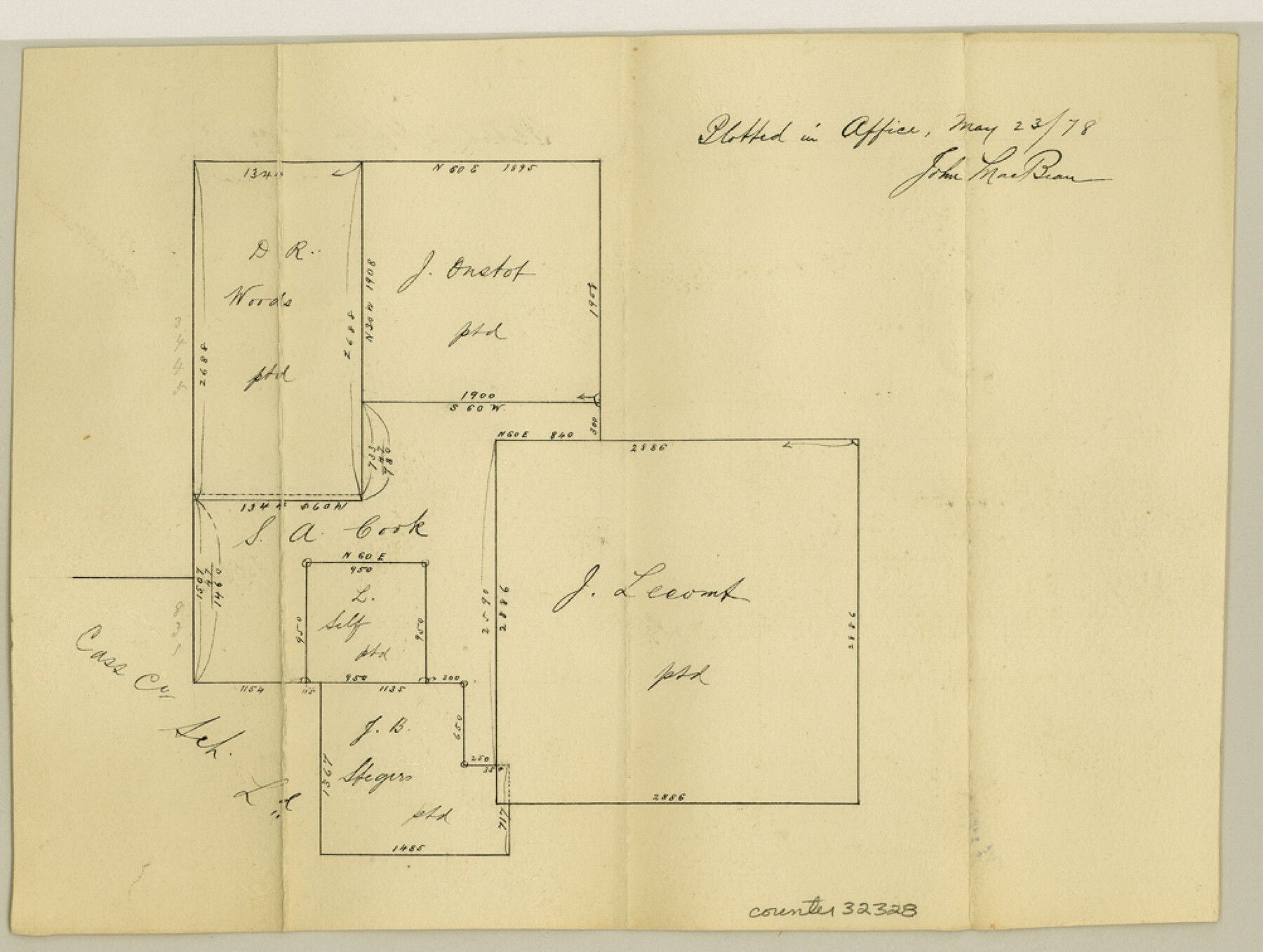
Navarro County Sketch File 15
[Office sketch of area in Navarro and Hill Counties southwest of Corsicana]
-
Map/Doc
32328
-
Collection
General Map Collection
-
Object Dates
5/23/1878 (Creation Date)
-
People and Organizations
J. Mac Bean (Surveyor/Engineer)
-
Counties
Navarro Hill
-
Subjects
Surveying Sketch File
-
Height x Width
7.6 x 10.0 inches
19.3 x 25.4 cm
-
Medium
paper, manuscript
Part of: General Map Collection
Bell County Working Sketch 17

Print $20.00
- Digital $50.00
Bell County Working Sketch 17
1983
Size 46.8 x 25.0 inches
Map/Doc 67357
Lipscomb County Sketch File 3

Print $20.00
- Digital $50.00
Lipscomb County Sketch File 3
Size 36.5 x 8.4 inches
Map/Doc 10526
Edwards County Working Sketch 91

Print $40.00
- Digital $50.00
Edwards County Working Sketch 91
1966
Size 34.8 x 51.1 inches
Map/Doc 68967
Flight Mission No. CRC-2R, Frame 134, Chambers County

Print $20.00
- Digital $50.00
Flight Mission No. CRC-2R, Frame 134, Chambers County
1956
Size 18.6 x 22.3 inches
Map/Doc 84750
Yoakum County Rolled Sketch 3(2)

Print $40.00
- Digital $50.00
Yoakum County Rolled Sketch 3(2)
1959
Size 12.7 x 128.8 inches
Map/Doc 10163
Matagorda County Sketch File 7

Print $20.00
- Digital $50.00
Matagorda County Sketch File 7
1890
Size 37.3 x 24.6 inches
Map/Doc 12038

Leon County Sketch File 9a

Print $6.00
- Digital $50.00
Leon County Sketch File 9a
1863
Size 10.5 x 8.6 inches
Map/Doc 29728
Stonewall County Working Sketch 6

Print $20.00
- Digital $50.00
Stonewall County Working Sketch 6
1949
Size 16.5 x 30.1 inches
Map/Doc 62313
Crockett County Sketch File 56

Print $20.00
- Digital $50.00
Crockett County Sketch File 56
Size 19.6 x 19.0 inches
Map/Doc 11224
Liberty County Working Sketch 28

Print $20.00
- Digital $50.00
Liberty County Working Sketch 28
1942
Size 22.4 x 23.2 inches
Map/Doc 70487
Hudspeth County Sketch File 20a

Print $10.00
- Digital $50.00
Hudspeth County Sketch File 20a
Size 10.8 x 8.2 inches
Map/Doc 26964
You may also like
Ward County Working Sketch 34

Print $20.00
- Digital $50.00
Ward County Working Sketch 34
1968
Size 26.7 x 30.5 inches
Map/Doc 72340

Angelina County Boundary File 2

Print $20.00
- Digital $50.00
Angelina County Boundary File 2
Size 10.2 x 28.2 inches
Map/Doc 49773
Madison County Working Sketch 3

Print $20.00
- Digital $50.00
Madison County Working Sketch 3
1945
Size 29.3 x 21.6 inches
Map/Doc 70765
[Sketch for Mineral Application 35981 - Liberty County, John Mecom]
![65618, [Sketch for Mineral Application 35981 - Liberty County, John Mecom], General Map Collection](https://historictexasmaps.com/wmedia_w700/maps/65618.tif.jpg)
Print $20.00
- Digital $50.00
[Sketch for Mineral Application 35981 - Liberty County, John Mecom]
1941
Size 30.1 x 26.4 inches
Map/Doc 65618
Dawson County Boundary File 3 (3)

Print $60.00
- Digital $50.00
Dawson County Boundary File 3 (3)
Size 11.0 x 35.8 inches
Map/Doc 52369
Austin County Working Sketch 1

Print $20.00
- Digital $50.00
Austin County Working Sketch 1
1941
Size 27.7 x 30.1 inches
Map/Doc 67242
Trinity County Working Sketch 4

Print $20.00
- Digital $50.00
Trinity County Working Sketch 4
1908
Size 21.3 x 18.5 inches
Map/Doc 69452
Maps of Gulf Intracoastal Waterway, Texas - Sabine River to the Rio Grande and connecting waterways including ship channels

Print $20.00
- Digital $50.00
Maps of Gulf Intracoastal Waterway, Texas - Sabine River to the Rio Grande and connecting waterways including ship channels
1966
Size 14.5 x 22.2 inches
Map/Doc 61915
Amarillo Improvements for Sawville-Amarillo Heights

Print $40.00
- Digital $50.00
Amarillo Improvements for Sawville-Amarillo Heights
Size 37.2 x 62.1 inches
Map/Doc 89789
![94159, Austin Street Map [Verso], General Map Collection](https://historictexasmaps.com/wmedia_w700/maps/94159.tif.jpg)
Jefferson County Working Sketch 13

Print $20.00
- Digital $50.00
Jefferson County Working Sketch 13
1948
Size 13.5 x 20.1 inches
Map/Doc 66556