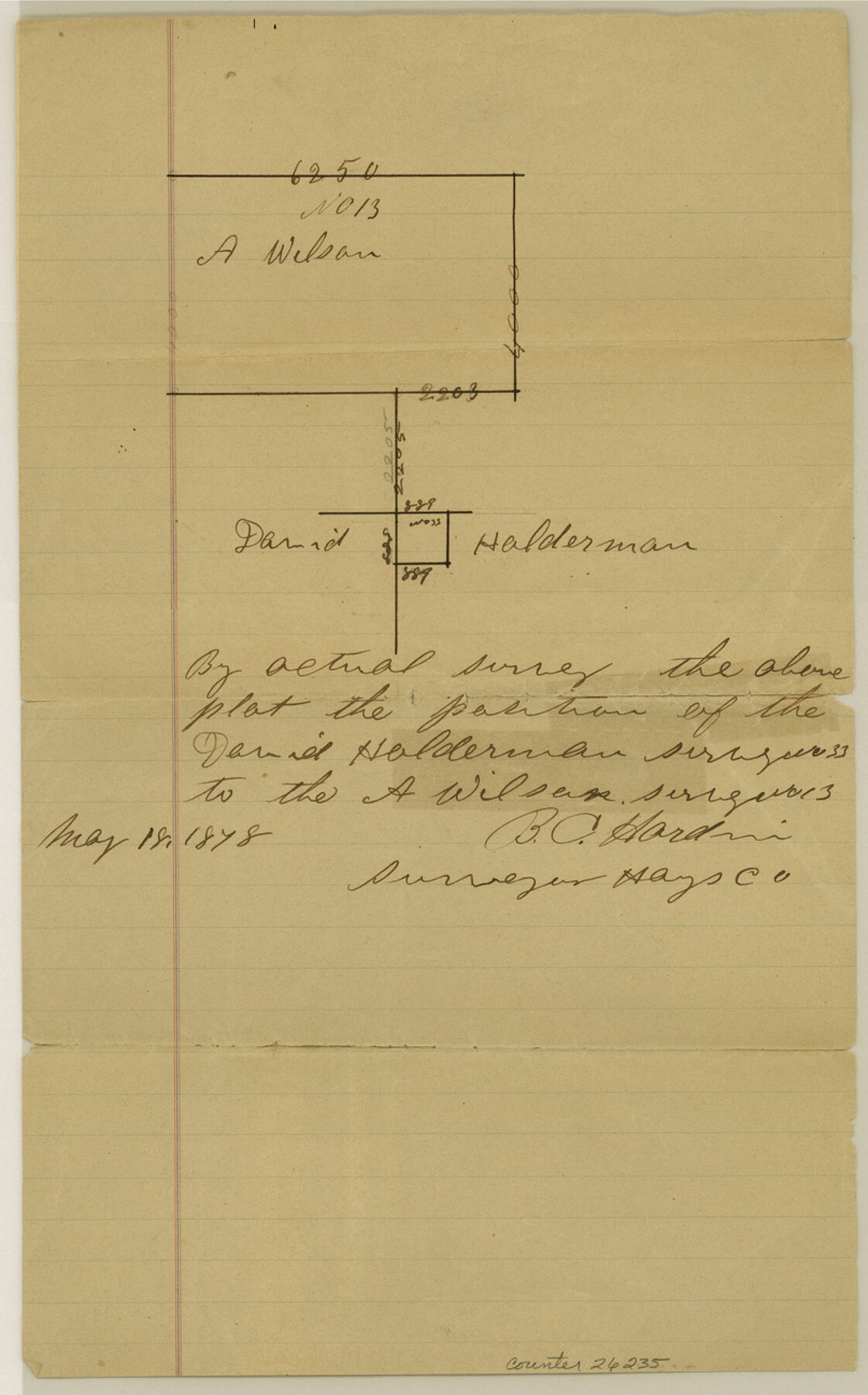
Hays County Sketch File 18
[Sketch showing location of David Halderman's survey]
-
Map/Doc
26235
-
Collection
General Map Collection
-
Object Dates
1878/5/17 (Creation Date)
1878/6/17 (File Date)
-
People and Organizations
B.C. Hardin (Surveyor/Engineer)
-
Counties
Hays
-
Subjects
Surveying Sketch File
-
Height x Width
13.0 x 8.1 inches
33.0 x 20.6 cm
-
Medium
paper, manuscript
Part of: General Map Collection
Amistad International Reservoir on Rio Grande 62

Print $20.00
- Digital $50.00
Amistad International Reservoir on Rio Grande 62
1949
Size 28.2 x 39.6 inches
Map/Doc 73347
[Map of Hidalgo County]
![6207, [Map of Hidalgo County], General Map Collection](https://historictexasmaps.com/wmedia_w700/maps/6207.tif.jpg)
Print $20.00
- Digital $50.00
[Map of Hidalgo County]
1882
Size 26.0 x 19.9 inches
Map/Doc 6207
Harris County Rolled Sketch 63

Print $40.00
- Digital $50.00
Harris County Rolled Sketch 63
1936
Size 41.4 x 52.5 inches
Map/Doc 9120
Controlled Mosaic by Jack Amman Photogrammetric Engineers, Inc - Sheet 8

Print $20.00
- Digital $50.00
Controlled Mosaic by Jack Amman Photogrammetric Engineers, Inc - Sheet 8
1954
Size 20.0 x 24.0 inches
Map/Doc 83452
Kerr County Sketch File 13

Print $11.00
- Digital $50.00
Kerr County Sketch File 13
1927
Size 16.9 x 8.1 inches
Map/Doc 28883
[Surveys near the city of Bastrop]
![107, [Surveys near the city of Bastrop], General Map Collection](https://historictexasmaps.com/wmedia_w700/maps/107.tif.jpg)
Print $2.00
- Digital $50.00
[Surveys near the city of Bastrop]
1841
Size 6.5 x 7.0 inches
Map/Doc 107
Kleberg County Rolled Sketch 12

Print $20.00
- Digital $50.00
Kleberg County Rolled Sketch 12
1994
Size 25.8 x 36.6 inches
Map/Doc 6553
Rio Grande Rectification Project, El Paso and Juarez Valley

Print $20.00
- Digital $50.00
Rio Grande Rectification Project, El Paso and Juarez Valley
1935
Size 10.7 x 29.7 inches
Map/Doc 60870
Flight Mission No. CRC-4R, Frame 154, Chambers County

Print $20.00
- Digital $50.00
Flight Mission No. CRC-4R, Frame 154, Chambers County
1956
Size 18.7 x 22.4 inches
Map/Doc 84917
Jefferson County Rolled Sketch 57

Print $20.00
- Digital $50.00
Jefferson County Rolled Sketch 57
1874
Size 25.9 x 18.6 inches
Map/Doc 6408
Dickens County Sketch File 31

Print $20.00
- Digital $50.00
Dickens County Sketch File 31
Size 22.3 x 9.5 inches
Map/Doc 11327
Leon County Sketch File 29

Print $8.00
- Digital $50.00
Leon County Sketch File 29
1951
Size 11.2 x 8.8 inches
Map/Doc 29825
You may also like
Brooks County

Print $20.00
- Digital $50.00
Brooks County
1955
Size 40.3 x 32.2 inches
Map/Doc 77223
Gaines County Sketch File 21

Print $6.00
- Digital $50.00
Gaines County Sketch File 21
1990
Size 11.2 x 8.8 inches
Map/Doc 23341
Concho, San Saba & Llano Valley Railway, Sterling City Branch, Texas. Right of Way and Track Map

Print $40.00
- Digital $50.00
Concho, San Saba & Llano Valley Railway, Sterling City Branch, Texas. Right of Way and Track Map
1910
Size 18.3 x 59.7 inches
Map/Doc 64439
Presidio County Working Sketch 111

Print $20.00
- Digital $50.00
Presidio County Working Sketch 111
1981
Size 17.1 x 20.4 inches
Map/Doc 71788
[Sketch of Plans and Bill of Material for 38' x 40' Texas Highway Dept. Warehouse]
![450, [Sketch of Plans and Bill of Material for 38' x 40' Texas Highway Dept. Warehouse], Maddox Collection](https://historictexasmaps.com/wmedia_w700/maps/450.tif.jpg)
Print $20.00
- Digital $50.00
[Sketch of Plans and Bill of Material for 38' x 40' Texas Highway Dept. Warehouse]
Size 23.7 x 22.8 inches
Map/Doc 450
Montague County Working Sketch 6

Print $20.00
- Digital $50.00
Montague County Working Sketch 6
1923
Size 16.9 x 27.2 inches
Map/Doc 71072
Houston County Working Sketch 3

Print $20.00
- Digital $50.00
Houston County Working Sketch 3
Size 16.7 x 18.5 inches
Map/Doc 66233
Flight Mission No. CGI-3N, Frame 171, Cameron County

Print $20.00
- Digital $50.00
Flight Mission No. CGI-3N, Frame 171, Cameron County
1954
Size 18.7 x 22.4 inches
Map/Doc 84635
Pecos County Working Sketch 72

Print $40.00
- Digital $50.00
Pecos County Working Sketch 72
1957
Size 106.0 x 43.6 inches
Map/Doc 71544
Approaches to Galveston Bay

Print $40.00
- Digital $50.00
Approaches to Galveston Bay
1982
Size 53.1 x 36.7 inches
Map/Doc 69884
Orange County Sketch File 11a

Print $4.00
- Digital $50.00
Orange County Sketch File 11a
1884
Size 6.1 x 6.1 inches
Map/Doc 33322
[Map of the City of Austin]
![4802, [Map of the City of Austin], General Map Collection](https://historictexasmaps.com/wmedia_w700/maps/4802-1.tif.jpg)
Print $20.00
- Digital $50.00
[Map of the City of Austin]
1856
Size 29.1 x 21.5 inches
Map/Doc 4802