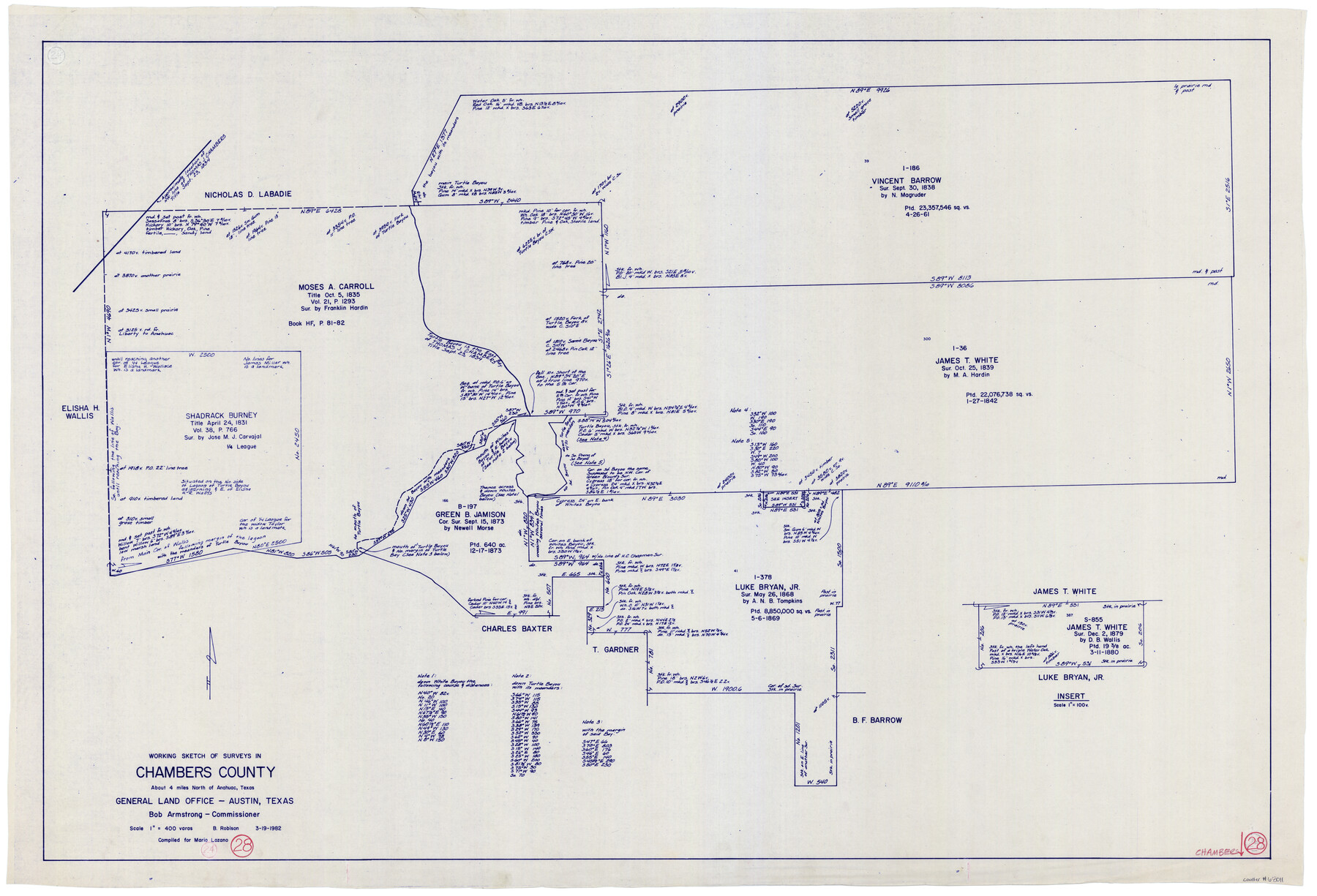
Chambers County Working Sketch 28
-
Map/Doc
68011
-
Collection
General Map Collection
-
Object Dates
3/19/1982 (Creation Date)
-
People and Organizations
Beverly Robison (Draftsman)
-
Counties
Chambers
-
Subjects
Surveying Working Sketch
-
Height x Width
28.7 x 42.3 inches
72.9 x 107.4 cm
-
Scale
1" = 400 varas
Part of: General Map Collection

[Missouri, Kansas & Texas Line Map through Bastrop County]
![64032, [Missouri, Kansas & Texas Line Map through Bastrop County], General Map Collection](https://historictexasmaps.com/wmedia_w700/maps/64032.tif.jpg)
Print $40.00
- Digital $50.00
[Missouri, Kansas & Texas Line Map through Bastrop County]
1916
Size 25.4 x 106.0 inches
Map/Doc 64032
Presidio County Working Sketch 23

Print $20.00
- Digital $50.00
Presidio County Working Sketch 23
1945
Size 35.7 x 23.3 inches
Map/Doc 71699
Harris County Rolled Sketch 90

Print $20.00
- Digital $50.00
Harris County Rolled Sketch 90
1981
Size 30.6 x 43.6 inches
Map/Doc 6129
Houston County

Print $40.00
- Digital $50.00
Houston County
1944
Size 50.3 x 50.3 inches
Map/Doc 73184
Flight Mission No. BRA-7M, Frame 74, Jefferson County

Print $20.00
- Digital $50.00
Flight Mission No. BRA-7M, Frame 74, Jefferson County
1953
Size 18.6 x 22.4 inches
Map/Doc 85496
Medina County Sketch File 10

Print $20.00
- Digital $50.00
Medina County Sketch File 10
Size 18.0 x 22.6 inches
Map/Doc 12068
J No. 9 - Reconnaissance of the Western Coast of the United States from San Francisco to San Diego

Print $20.00
- Digital $50.00
J No. 9 - Reconnaissance of the Western Coast of the United States from San Francisco to San Diego
1852
Size 24.5 x 24.4 inches
Map/Doc 97236
Aransas County Rolled Sketch 2

Print $40.00
- Digital $50.00
Aransas County Rolled Sketch 2
1950
Size 27.9 x 51.4 inches
Map/Doc 73613
Reagan County Boundary File 1a

Print $50.00
- Digital $50.00
Reagan County Boundary File 1a
Size 14.4 x 8.7 inches
Map/Doc 58154
Aransas County Rolled Sketch 16

Print $40.00
- Digital $50.00
Aransas County Rolled Sketch 16
1965
Size 45.9 x 92.9 inches
Map/Doc 9005
Bexar County Working Sketch 8

Print $20.00
- Digital $50.00
Bexar County Working Sketch 8
1954
Size 26.8 x 25.2 inches
Map/Doc 67324
You may also like
Frio County Sketch File 23

Print $6.00
- Digital $50.00
Frio County Sketch File 23
2013
Size 11.0 x 8.5 inches
Map/Doc 93418
Webb County Rolled Sketch 41

Print $20.00
- Digital $50.00
Webb County Rolled Sketch 41
1941
Size 25.0 x 18.0 inches
Map/Doc 8196
Index sheet to accompany map of survey for connecting the inland waters along margin of the Gulf of Mexico from Donaldsonville in Louisiana to the Rio Grande River in Texas

Print $20.00
- Digital $50.00
Index sheet to accompany map of survey for connecting the inland waters along margin of the Gulf of Mexico from Donaldsonville in Louisiana to the Rio Grande River in Texas
Size 18.2 x 27.4 inches
Map/Doc 72690
Jasper County Working Sketch 5

Print $20.00
- Digital $50.00
Jasper County Working Sketch 5
1906
Size 26.8 x 38.0 inches
Map/Doc 66467
Morris County Rolled Sketch 2

Print $40.00
- Digital $50.00
Morris County Rolled Sketch 2
1944
Size 59.4 x 43.5 inches
Map/Doc 9550
The Republic County of San Patricio. Proposed, Late Fall 1837

Print $20.00
The Republic County of San Patricio. Proposed, Late Fall 1837
2020
Size 17.8 x 21.7 inches
Map/Doc 96273
Tarrant County Sketch File 12

Print $4.00
- Digital $50.00
Tarrant County Sketch File 12
1859
Size 10.1 x 8.3 inches
Map/Doc 37703
Chambers County NRC Article 33.136 Sketch 6

Print $58.00
- Digital $50.00
Chambers County NRC Article 33.136 Sketch 6
2007
Size 11.0 x 8.5 inches
Map/Doc 88802
Uvalde County Working Sketch 41

Print $20.00
- Digital $50.00
Uvalde County Working Sketch 41
1975
Size 15.6 x 27.4 inches
Map/Doc 72111
Nueces County Rolled Sketch 109

Print $20.00
- Digital $50.00
Nueces County Rolled Sketch 109
1989
Size 18.8 x 25.0 inches
Map/Doc 7116
Uvalde County Sketch File 29

Print $8.00
- Digital $50.00
Uvalde County Sketch File 29
1873
Size 13.0 x 8.3 inches
Map/Doc 39028
Map of Anderson County

Print $20.00
- Digital $50.00
Map of Anderson County
1879
Size 18.9 x 23.5 inches
Map/Doc 3229