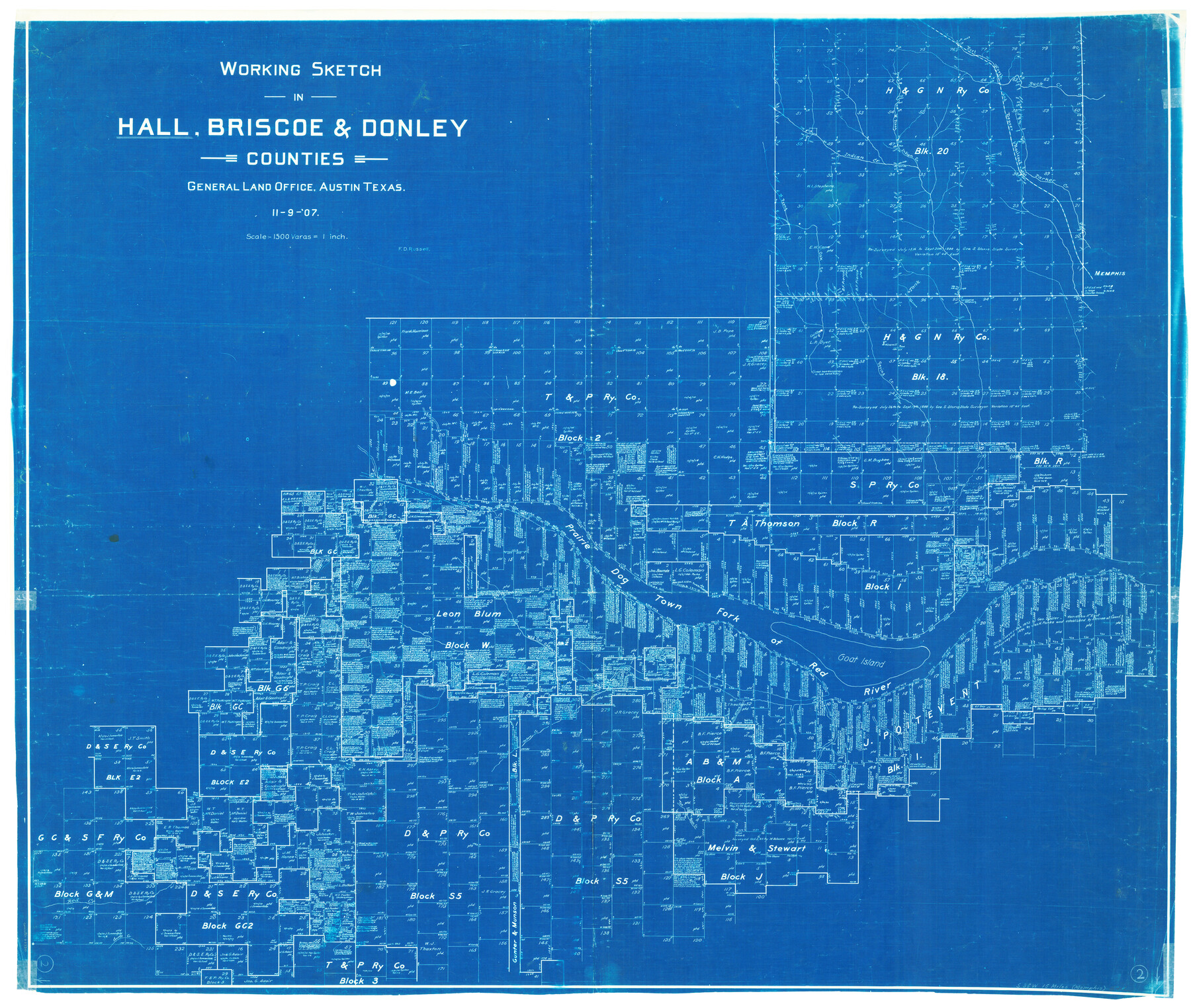
Hall County Working Sketch 2
-
Map/Doc
63330
-
Collection
General Map Collection
-
Object Dates
11/9/1907 (Creation Date)
-
People and Organizations
F.D. Russell (Draftsman)
-
Counties
Hall Briscoe Donley
-
Subjects
Surveying Working Sketch
-
Height x Width
40.9 x 48.4 inches
103.9 x 122.9 cm
-
Scale
1" = 1500 varas
Part of: General Map Collection
[Aerial photograph from Carancahua Bend of Caney Creek to Cedar Lake]
![78639, [Aerial photograph from Carancahua Bend of Caney Creek to Cedar Lake], General Map Collection](https://historictexasmaps.com/wmedia_w700/maps/78639.tif.jpg)
Print $20.00
- Digital $50.00
[Aerial photograph from Carancahua Bend of Caney Creek to Cedar Lake]
1991
Size 24.4 x 34.0 inches
Map/Doc 78639
Flight Mission No. BQY-4M, Frame 55, Harris County

Print $20.00
- Digital $50.00
Flight Mission No. BQY-4M, Frame 55, Harris County
1953
Size 18.5 x 22.3 inches
Map/Doc 85264
Throckmorton County Sketch File 5a

Print $22.00
- Digital $50.00
Throckmorton County Sketch File 5a
Size 8.0 x 7.8 inches
Map/Doc 38075
San Saba County Sketch File 11

Print $8.00
- Digital $50.00
San Saba County Sketch File 11
1882
Size 12.4 x 8.3 inches
Map/Doc 36435
Kinney County Working Sketch 45

Print $20.00
- Digital $50.00
Kinney County Working Sketch 45
1978
Size 28.6 x 26.5 inches
Map/Doc 70227
Flight Mission No. DAG-24K, Frame 135, Matagorda County

Print $20.00
- Digital $50.00
Flight Mission No. DAG-24K, Frame 135, Matagorda County
1953
Size 18.4 x 22.2 inches
Map/Doc 86553
Borden County Rolled Sketch 7A

Print $20.00
- Digital $50.00
Borden County Rolled Sketch 7A
1940
Size 16.4 x 18.9 inches
Map/Doc 5158
Angelina County Working Sketch 36

Print $20.00
- Digital $50.00
Angelina County Working Sketch 36
1957
Size 14.4 x 18.3 inches
Map/Doc 67119
Wichita County Sketch File 9a

Print $4.00
- Digital $50.00
Wichita County Sketch File 9a
Size 10.7 x 8.2 inches
Map/Doc 40052
Jefferson County Rolled Sketch 28

Print $20.00
- Digital $50.00
Jefferson County Rolled Sketch 28
1948
Size 22.4 x 32.9 inches
Map/Doc 6391
Blanco County Sketch File 12

Print $20.00
- Digital $50.00
Blanco County Sketch File 12
Size 15.0 x 19.8 inches
Map/Doc 10928
Glasscock County Sketch File 20

Print $40.00
- Digital $50.00
Glasscock County Sketch File 20
1935
Size 15.6 x 12.6 inches
Map/Doc 24196
You may also like

Harris County Working Sketch 106

Print $40.00
- Digital $50.00
Harris County Working Sketch 106
1981
Size 48.0 x 25.0 inches
Map/Doc 65998
Medina County Rolled Sketch 15

Print $20.00
- Digital $50.00
Medina County Rolled Sketch 15
1980
Size 25.2 x 20.3 inches
Map/Doc 6749
Sketch of North Line of T&P Eighty Mile Reserve

Print $20.00
- Digital $50.00
Sketch of North Line of T&P Eighty Mile Reserve
1914
Size 43.0 x 9.8 inches
Map/Doc 2245
Presidio County Working Sketch 10

Print $40.00
- Digital $50.00
Presidio County Working Sketch 10
1940
Size 42.1 x 67.1 inches
Map/Doc 71685
[Galveston, Harrisburg & San Antonio through El Paso County]
![64014, [Galveston, Harrisburg & San Antonio through El Paso County], General Map Collection](https://historictexasmaps.com/wmedia_w700/maps/64014.tif.jpg)
Print $20.00
- Digital $50.00
[Galveston, Harrisburg & San Antonio through El Paso County]
1906
Size 13.4 x 33.8 inches
Map/Doc 64014
Township 10 North Range 15 West, North Western District, Louisiana

Print $20.00
- Digital $50.00
Township 10 North Range 15 West, North Western District, Louisiana
1854
Size 19.5 x 24.6 inches
Map/Doc 65871
1938 Tydol Trails New York

Print $20.00
- Digital $50.00
1938 Tydol Trails New York
1938
Size 27.2 x 31.8 inches
Map/Doc 97111
Brewster County Sketch File 21

Print $40.00
- Digital $50.00
Brewster County Sketch File 21
Size 23.1 x 18.9 inches
Map/Doc 10980
San Jacinto County Rolled Sketch 14

Print $20.00
- Digital $50.00
San Jacinto County Rolled Sketch 14
1998
Size 25.7 x 37.2 inches
Map/Doc 7570
Palo Pinto County Working Sketch 16

Print $20.00
- Digital $50.00
Palo Pinto County Working Sketch 16
1974
Size 35.5 x 42.4 inches
Map/Doc 71399
La Salle County

Print $20.00
- Digital $50.00
La Salle County
1923
Size 39.7 x 34.5 inches
Map/Doc 77348