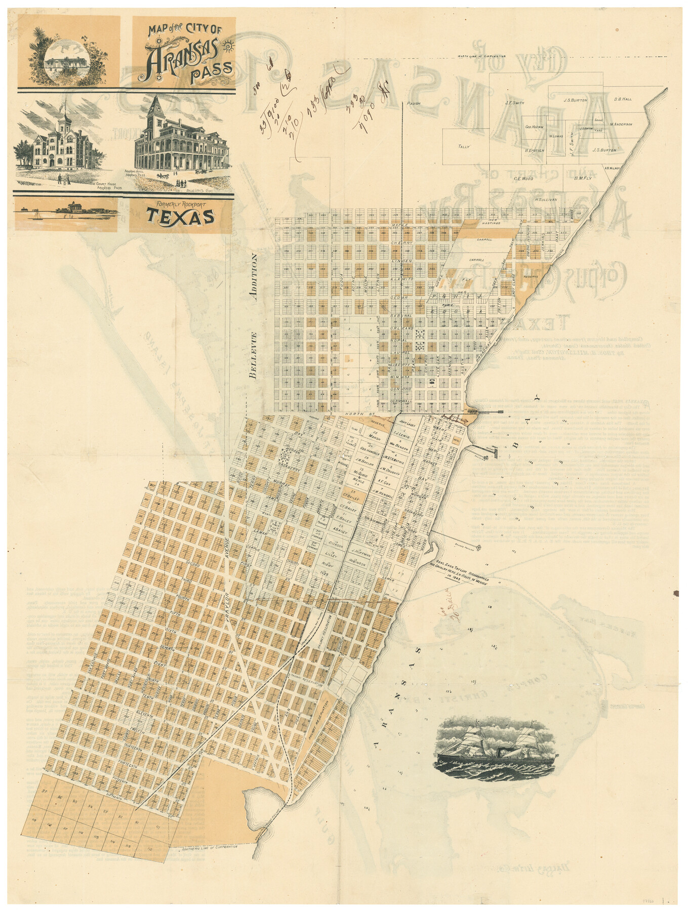
Map of the City of Aransas Pass
-
Map/Doc
97266
-
Collection
General Map Collection
-
Object Dates
[1905] (Creation Date)
-
People and Organizations
Thos. H. Millington (Surveyor/Engineer)
-
Counties
Aransas
-
Subjects
City
-
Height x Width
28.3 x 21.4 inches
71.9 x 54.4 cm
-
Comments
See 97265 for map on verso.
Related maps
City of Aransas Pass and Chart of Aransas Bay and Corpus Christi Bay, Texas

Print $20.00
- Digital $50.00
City of Aransas Pass and Chart of Aransas Bay and Corpus Christi Bay, Texas
1905
Size 28.4 x 21.4 inches
Map/Doc 97265
Part of: General Map Collection
Red River County Working Sketch 29

Print $20.00
- Digital $50.00
Red River County Working Sketch 29
1961
Size 29.5 x 33.3 inches
Map/Doc 72012
Briscoe County Rolled Sketch 17

Print $20.00
- Digital $50.00
Briscoe County Rolled Sketch 17
1946
Size 36.7 x 28.7 inches
Map/Doc 5331
Montgomery County Working Sketch 53

Print $20.00
- Digital $50.00
Montgomery County Working Sketch 53
1961
Size 28.2 x 30.2 inches
Map/Doc 71160
Menard County Sketch File 15

Print $8.00
- Digital $50.00
Menard County Sketch File 15
1892
Size 12.9 x 8.3 inches
Map/Doc 31510
Flight Mission No. DCL-7C, Frame 123, Kenedy County

Print $20.00
- Digital $50.00
Flight Mission No. DCL-7C, Frame 123, Kenedy County
1943
Size 18.5 x 22.2 inches
Map/Doc 86088
Sketch of surveys in Shelby Co.

Print $2.00
- Digital $50.00
Sketch of surveys in Shelby Co.
1845
Size 6.4 x 8.8 inches
Map/Doc 69741
Donley County Boundary File 9

Print $50.00
- Digital $50.00
Donley County Boundary File 9
1903
Size 13.0 x 8.1 inches
Map/Doc 62233
Township 15 South Range 15 West and Fractional Township 16 South Range 15 West, South Western District, Louisiana

Print $20.00
- Digital $50.00
Township 15 South Range 15 West and Fractional Township 16 South Range 15 West, South Western District, Louisiana
1875
Size 19.6 x 24.7 inches
Map/Doc 65861
Hemphill County Working Sketch Graphic Index - sheet 1

Print $20.00
- Digital $50.00
Hemphill County Working Sketch Graphic Index - sheet 1
1899
Size 40.1 x 38.2 inches
Map/Doc 76574
1968 Texas Official State Highway Map

Digital $50.00
1968 Texas Official State Highway Map
Size 28.1 x 36.5 inches
Map/Doc 94319
Orange County Sketch File 23

Print $36.00
- Digital $50.00
Orange County Sketch File 23
1911
Size 9.2 x 5.9 inches
Map/Doc 33344
Val Verde County Working Sketch 117

Print $20.00
- Digital $50.00
Val Verde County Working Sketch 117
1993
Size 30.9 x 37.0 inches
Map/Doc 82844
You may also like
Hardin County Sketch File 17

Print $6.00
- Digital $50.00
Hardin County Sketch File 17
1854
Size 15.9 x 9.9 inches
Map/Doc 25130
Bowie County Sketch File 6d

Print $4.00
- Digital $50.00
Bowie County Sketch File 6d
1927
Size 11.4 x 9.0 inches
Map/Doc 14850
General Highway Map, Llano County, Texas

Print $20.00
General Highway Map, Llano County, Texas
1961
Size 18.2 x 24.6 inches
Map/Doc 79576
Martin County Rolled Sketch 7

Print $20.00
- Digital $50.00
Martin County Rolled Sketch 7
1929
Size 23.0 x 31.2 inches
Map/Doc 6667
Midland County

Print $20.00
- Digital $50.00
Midland County
1901
Size 43.7 x 40.3 inches
Map/Doc 66929
Goliad County Sketch File A

Print $20.00
- Digital $50.00
Goliad County Sketch File A
1897
Size 30.6 x 32.9 inches
Map/Doc 10465

Howard County Sketch File 2a

Print $20.00
- Digital $50.00
Howard County Sketch File 2a
1909
Size 32.8 x 25.6 inches
Map/Doc 11792
Flight Mission No. DQN-2K, Frame 30, Calhoun County

Print $20.00
- Digital $50.00
Flight Mission No. DQN-2K, Frame 30, Calhoun County
1953
Size 18.5 x 22.2 inches
Map/Doc 84237
Brazos River, Brazos River Sheet 2

Print $20.00
- Digital $50.00
Brazos River, Brazos River Sheet 2
1926
Size 25.2 x 31.0 inches
Map/Doc 78265
General Highway Map, Ochiltree County, Texas

Print $20.00
General Highway Map, Ochiltree County, Texas
1940
Size 18.2 x 24.8 inches
Map/Doc 79211
North Line of Lynn County and South Line of Lubbock County

Print $20.00
- Digital $50.00
North Line of Lynn County and South Line of Lubbock County
1892
Size 8.0 x 34.2 inches
Map/Doc 91393