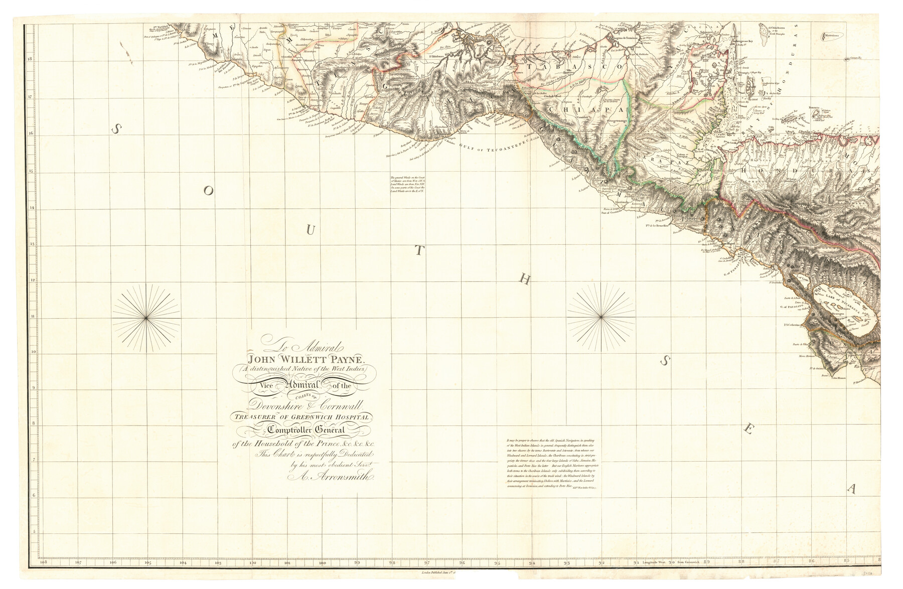
Chart of the West Indies and Spanish Dominions in North America
-
Map/Doc
97138
-
Collection
General Map Collection
-
Object Dates
6/1/1803 (Creation Date)
-
People and Organizations
A. Arrowsmith (Publisher)
-
Height x Width
25.6 x 39.2 inches
65.0 x 99.6 cm
-
Comments
SW quadrant of a map in four pieces. See 97136, 97137, and 97139 for other pieces. See 97153 for digital composite of all four pieces.
Related maps
Chart of the West Indies and Spanish Dominions in North America

Print $20.00
- Digital $50.00
Chart of the West Indies and Spanish Dominions in North America
1803
Size 25.3 x 38.4 inches
Map/Doc 97136
Chart of the West Indies and Spanish Dominions in North America

Print $20.00
- Digital $50.00
Chart of the West Indies and Spanish Dominions in North America
1803
Size 25.7 x 39.4 inches
Map/Doc 97137
Chart of the West Indies and Spanish Dominions in North America

Print $20.00
- Digital $50.00
Chart of the West Indies and Spanish Dominions in North America
1803
Size 25.5 x 38.9 inches
Map/Doc 97139
Chart of the West Indies and Spanish Dominions in North America

Print $40.00
- Digital $50.00
Chart of the West Indies and Spanish Dominions in North America
Size 49.1 x 75.6 inches
Map/Doc 97153
Part of: General Map Collection
Jefferson County Rolled Sketch 61G

Print $20.00
- Digital $50.00
Jefferson County Rolled Sketch 61G
1928
Size 27.2 x 40.3 inches
Map/Doc 6416
Matagorda County NRC Article 33.136 Sketch 9

Print $28.00
- Digital $50.00
Matagorda County NRC Article 33.136 Sketch 9
2011
Size 24.0 x 36.0 inches
Map/Doc 94811
Texas and part of Mexico & the United States, showing the route of the first Santa Fe Expedition

Print $20.00
- Digital $50.00
Texas and part of Mexico & the United States, showing the route of the first Santa Fe Expedition
1844
Size 18.1 x 13.2 inches
Map/Doc 94035
Bailey County Sketch File 19

Print $8.00
- Digital $50.00
Bailey County Sketch File 19
1882
Size 13.2 x 8.4 inches
Map/Doc 13987
Travis County Sketch File 11a

Print $4.00
- Digital $50.00
Travis County Sketch File 11a
1873
Size 10.0 x 8.0 inches
Map/Doc 38302
Map of north end of Brazos Island

Print $20.00
- Digital $50.00
Map of north end of Brazos Island
Size 27.5 x 18.3 inches
Map/Doc 72906
Hood County Sketch File 28

Print $84.00
- Digital $50.00
Hood County Sketch File 28
1880
Size 11.6 x 9.0 inches
Map/Doc 26631
Henderson County Boundary File 3b

Print $14.00
- Digital $50.00
Henderson County Boundary File 3b
Size 14.4 x 8.9 inches
Map/Doc 54700
Fisher County Sketch File 3

Print $56.00
- Digital $50.00
Fisher County Sketch File 3
1886
Size 8.9 x 5.8 inches
Map/Doc 22549
Bexar County Sketch File 57

Print $4.00
- Digital $50.00
Bexar County Sketch File 57
1847
Size 10.4 x 8.3 inches
Map/Doc 14570
Bandera County Working Sketch 56

Print $20.00
- Digital $50.00
Bandera County Working Sketch 56
1991
Size 28.1 x 35.1 inches
Map/Doc 67652
La Salle County Working Sketch 38

Print $20.00
- Digital $50.00
La Salle County Working Sketch 38
1961
Size 26.6 x 18.4 inches
Map/Doc 70339
You may also like
Burnet County Rolled Sketch 4

Print $20.00
- Digital $50.00
Burnet County Rolled Sketch 4
1949
Size 31.9 x 17.5 inches
Map/Doc 5356
Flight Mission No. DCL-7C, Frame 114, Kenedy County

Print $20.00
- Digital $50.00
Flight Mission No. DCL-7C, Frame 114, Kenedy County
1943
Size 18.6 x 22.2 inches
Map/Doc 86079
[Map of Tom Green County]
![82061, [Map of Tom Green County], General Map Collection](https://historictexasmaps.com/wmedia_w700/maps/82061.tif.jpg)
Print $40.00
- Digital $50.00
[Map of Tom Green County]
1933
Size 50.0 x 60.6 inches
Map/Doc 82061
Flight Mission No. BRA-9M, Frame 64, Jefferson County

Print $20.00
- Digital $50.00
Flight Mission No. BRA-9M, Frame 64, Jefferson County
1953
Size 18.6 x 22.4 inches
Map/Doc 85647
Flight Mission No. DQO-1K, Frame 151, Galveston County

Print $20.00
- Digital $50.00
Flight Mission No. DQO-1K, Frame 151, Galveston County
1952
Size 18.8 x 22.5 inches
Map/Doc 85004
Flight Mission No. DIX-8P, Frame 94, Aransas County

Print $20.00
- Digital $50.00
Flight Mission No. DIX-8P, Frame 94, Aransas County
1956
Size 18.5 x 22.3 inches
Map/Doc 83919
Hamilton County Sketch File 15

Print $2.00
- Digital $50.00
Hamilton County Sketch File 15
1882
Size 8.0 x 11.8 inches
Map/Doc 24941
Lubbock County Boundary File 1

Print $64.00
- Digital $50.00
Lubbock County Boundary File 1
Size 8.8 x 8.6 inches
Map/Doc 56455
Hardin County Sketch File 32a

Print $11.00
- Digital $50.00
Hardin County Sketch File 32a
Size 8.4 x 9.8 inches
Map/Doc 25167
America siue India Nova ad magnae Gerardi Mercatoris aui Vniversalis imitationem in compendium redacta

Print $20.00
- Digital $50.00
America siue India Nova ad magnae Gerardi Mercatoris aui Vniversalis imitationem in compendium redacta
1585
Size 16.9 x 20.2 inches
Map/Doc 93808
Map of T. C. Spearman's Lands in Gaines, Terry & Yoakum Counties, Texas

Print $20.00
- Digital $50.00
Map of T. C. Spearman's Lands in Gaines, Terry & Yoakum Counties, Texas
1917
Size 46.0 x 37.6 inches
Map/Doc 89842
[Right of Way & Track Map, The Texas & Pacific Ry. Co. Main Line]
![64688, [Right of Way & Track Map, The Texas & Pacific Ry. Co. Main Line], General Map Collection](https://historictexasmaps.com/wmedia_w700/maps/64688.tif.jpg)
Print $20.00
- Digital $50.00
[Right of Way & Track Map, The Texas & Pacific Ry. Co. Main Line]
Size 11.0 x 19.0 inches
Map/Doc 64688