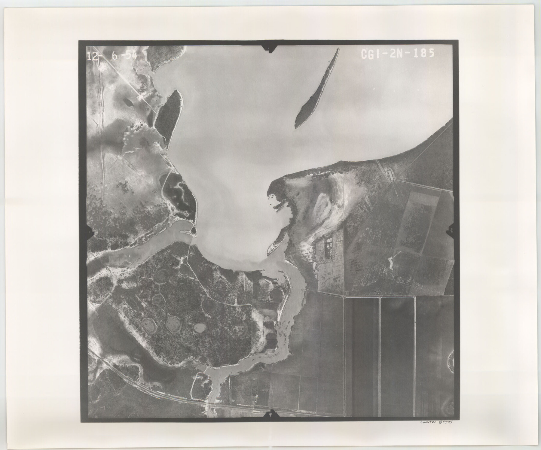
Flight Mission No. CGI-2N, Frame 185, Cameron County
CGI-2N-185
-
Map/Doc
84545
-
Collection
General Map Collection
-
Object Dates
1954/12/6 (Creation Date)
-
People and Organizations
U. S. Department of Agriculture (Publisher)
-
Counties
Cameron
-
Subjects
Aerial Photograph
-
Height x Width
18.5 x 22.2 inches
47.0 x 56.4 cm
-
Comments
Flown by Puckett Aerial Surveys, Inc. of Jackson, Mississippi.
Part of: General Map Collection
Garza County Rolled Sketch 17

Print $20.00
- Digital $50.00
Garza County Rolled Sketch 17
1959
Size 32.3 x 37.6 inches
Map/Doc 6003
Intracoastal Waterway in Texas - Corpus Christi to Point Isabel including Arroyo Colorado to Mo. Pac. R.R. Bridge Near Harlingen

Print $20.00
- Digital $50.00
Intracoastal Waterway in Texas - Corpus Christi to Point Isabel including Arroyo Colorado to Mo. Pac. R.R. Bridge Near Harlingen
1933
Size 28.0 x 41.0 inches
Map/Doc 61860
Terrell County Working Sketch 33

Print $20.00
- Digital $50.00
Terrell County Working Sketch 33
1945
Size 16.1 x 31.6 inches
Map/Doc 62125
Leon County Working Sketch 27

Print $20.00
- Digital $50.00
Leon County Working Sketch 27
1970
Size 22.4 x 24.4 inches
Map/Doc 70426
Travis County Sketch File 48

Print $6.00
- Digital $50.00
Travis County Sketch File 48
1940
Size 11.4 x 8.8 inches
Map/Doc 38377
San Jacinto County Sketch File 8

Print $4.00
San Jacinto County Sketch File 8
Size 10.2 x 7.9 inches
Map/Doc 35710
[Surveys along Richland Creek]
![320, [Surveys along Richland Creek], General Map Collection](https://historictexasmaps.com/wmedia_w700/maps/320.tif.jpg)
Print $2.00
- Digital $50.00
[Surveys along Richland Creek]
Size 7.2 x 6.0 inches
Map/Doc 320
[Surveys along Richland Creek]
![322, [Surveys along Richland Creek], General Map Collection](https://historictexasmaps.com/wmedia_w700/maps/322.tif.jpg)
Print $2.00
- Digital $50.00
[Surveys along Richland Creek]
Size 6.0 x 5.0 inches
Map/Doc 322
Brewster County Sketch File NS-8

Print $311.00
- Digital $50.00
Brewster County Sketch File NS-8
Size 15.0 x 9.1 inches
Map/Doc 15999

Johnson County Working Sketch 17

Print $40.00
- Digital $50.00
Johnson County Working Sketch 17
1985
Size 48.3 x 44.4 inches
Map/Doc 66630
Cameron County Rolled Sketch 20D

Print $20.00
- Digital $50.00
Cameron County Rolled Sketch 20D
Size 14.3 x 13.9 inches
Map/Doc 5477
You may also like
Plat of NE portion of Leagues 3 & 4, McLennan Co. School Land taken from official map filed in District Court

Print $3.00
- Digital $50.00
Plat of NE portion of Leagues 3 & 4, McLennan Co. School Land taken from official map filed in District Court
Size 11.6 x 9.9 inches
Map/Doc 90927
G. C. & S. F., Main Line, Texas, Right of Way map, Rio Vista to Crowley

Print $40.00
- Digital $50.00
G. C. & S. F., Main Line, Texas, Right of Way map, Rio Vista to Crowley
1916
Size 40.2 x 92.0 inches
Map/Doc 64654
Fractional Township No. 8 South Range No. 14 East of the Indian Meridian, Indian Territory

Print $20.00
- Digital $50.00
Fractional Township No. 8 South Range No. 14 East of the Indian Meridian, Indian Territory
1896
Size 19.2 x 24.3 inches
Map/Doc 75225
Flight Mission No. DIX-6P, Frame 132, Aransas County

Print $20.00
- Digital $50.00
Flight Mission No. DIX-6P, Frame 132, Aransas County
1956
Size 19.3 x 23.2 inches
Map/Doc 83838
Runnels County Rolled Sketch 46

Print $20.00
- Digital $50.00
Runnels County Rolled Sketch 46
1954
Size 33.5 x 39.0 inches
Map/Doc 9872
Map of Washington County

Print $20.00
- Digital $50.00
Map of Washington County
1841
Size 28.5 x 29.0 inches
Map/Doc 4122
Stonewall County Working Sketch 34

Print $20.00
- Digital $50.00
Stonewall County Working Sketch 34
1985
Size 34.0 x 33.9 inches
Map/Doc 62341
Dimmit County Working Sketch 45

Print $20.00
- Digital $50.00
Dimmit County Working Sketch 45
1979
Size 44.7 x 35.5 inches
Map/Doc 68706
Flight Mission No. BRA-16M, Frame 94, Jefferson County

Print $20.00
- Digital $50.00
Flight Mission No. BRA-16M, Frame 94, Jefferson County
1953
Size 18.5 x 22.1 inches
Map/Doc 85706
Uvalde County Sketch File 31

Print $4.00
- Digital $50.00
Uvalde County Sketch File 31
Size 11.2 x 8.8 inches
Map/Doc 81529
Edwards County Working Sketch 126

Print $20.00
- Digital $50.00
Edwards County Working Sketch 126
1980
Size 33.5 x 47.0 inches
Map/Doc 69002
[Wilson Strickland Survey and Vicinity, Exhibit L]
![91377, [Wilson Strickland Survey and Vicinity, Exhibit L], Twichell Survey Records](https://historictexasmaps.com/wmedia_w700/maps/91377-1.tif.jpg)
Print $20.00
- Digital $50.00
[Wilson Strickland Survey and Vicinity, Exhibit L]
Size 32.8 x 27.1 inches
Map/Doc 91377