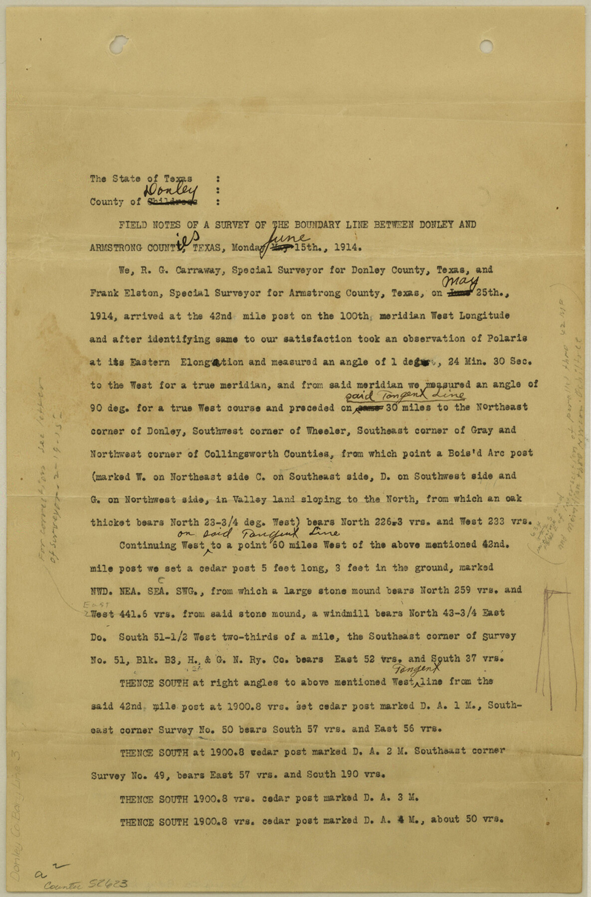
Donley County Boundary File 3
Sketch of the boundry [sp.] line of Donley and Armstrong Counties Texas
-
Map/Doc
52623
-
Collection
General Map Collection
-
Counties
Donley
-
Subjects
County Boundaries
-
Height x Width
13.2 x 8.7 inches
33.5 x 22.1 cm
Part of: General Map Collection
McMullen County Sketch File 29

Print $20.00
- Digital $50.00
McMullen County Sketch File 29
1883
Size 35.8 x 15.4 inches
Map/Doc 12062
Lamar County Sketch File 8

Print $20.00
- Digital $50.00
Lamar County Sketch File 8
1895
Size 21.4 x 23.1 inches
Map/Doc 11966
Mason County Rolled Sketch 1

Print $20.00
- Digital $50.00
Mason County Rolled Sketch 1
1939
Size 38.3 x 26.8 inches
Map/Doc 6672
Blanco County Sketch File 47

Print $46.00
- Digital $50.00
Blanco County Sketch File 47
Size 14.4 x 8.7 inches
Map/Doc 14675
Menard County Working Sketch 30

Print $20.00
- Digital $50.00
Menard County Working Sketch 30
1974
Size 47.9 x 38.8 inches
Map/Doc 70977
Galveston County NRC Article 33.136 Sketch 30

Print $20.00
- Digital $50.00
Galveston County NRC Article 33.136 Sketch 30
2005
Size 12.1 x 15.5 inches
Map/Doc 82997
Hardin County Sketch File AB

Print $4.00
- Digital $50.00
Hardin County Sketch File AB
Size 13.5 x 7.3 inches
Map/Doc 25071
Crockett County Sketch File 97

Print $20.00
- Digital $50.00
Crockett County Sketch File 97
Size 14.1 x 9.3 inches
Map/Doc 19966
Wharton County Working Sketch 16

Print $20.00
- Digital $50.00
Wharton County Working Sketch 16
1952
Size 23.8 x 26.8 inches
Map/Doc 72480
Orange County Sabine River Leases 1,2,3,4

Print $20.00
- Digital $50.00
Orange County Sabine River Leases 1,2,3,4
1950
Size 36.5 x 22.4 inches
Map/Doc 1931
Matagorda County Working Sketch 16

Print $20.00
- Digital $50.00
Matagorda County Working Sketch 16
1960
Size 34.6 x 31.8 inches
Map/Doc 70874
Webb County Rolled Sketch 61

Print $20.00
- Digital $50.00
Webb County Rolled Sketch 61
1947
Size 38.6 x 36.5 inches
Map/Doc 10128
You may also like
San Patricio County Rolled Sketch 42

Print $20.00
- Digital $50.00
San Patricio County Rolled Sketch 42
Size 18.6 x 37.3 inches
Map/Doc 7728
Wise County Sketch File F

Print $20.00
- Digital $50.00
Wise County Sketch File F
1857
Size 16.2 x 29.2 inches
Map/Doc 12704
Jeff Davis County Rolled Sketch 21

Print $20.00
- Digital $50.00
Jeff Davis County Rolled Sketch 21
1946
Size 46.5 x 38.7 inches
Map/Doc 9267
Map Showing Section Lines and Corporation Lines of the City of Lubbock

Print $20.00
- Digital $50.00
Map Showing Section Lines and Corporation Lines of the City of Lubbock
1921
Size 27.5 x 25.2 inches
Map/Doc 92749
Navigation Maps of Gulf Intracoastal Waterway, Port Arthur to Brownsville, Texas

Print $4.00
- Digital $50.00
Navigation Maps of Gulf Intracoastal Waterway, Port Arthur to Brownsville, Texas
1951
Size 16.6 x 21.2 inches
Map/Doc 65445
Kimble County Working Sketch 80

Print $20.00
- Digital $50.00
Kimble County Working Sketch 80
1971
Size 32.3 x 24.3 inches
Map/Doc 70148
[Surveys in the Bexar District along the Nueces and Leona Rivers]
![116, [Surveys in the Bexar District along the Nueces and Leona Rivers], General Map Collection](https://historictexasmaps.com/wmedia_w700/maps/116.tif.jpg)
Print $3.00
- Digital $50.00
[Surveys in the Bexar District along the Nueces and Leona Rivers]
1845
Size 10.9 x 14.3 inches
Map/Doc 116
[Map Showing Surveys in Dimmit & La Salle Counties, Texas]
![75791, [Map Showing Surveys in Dimmit & La Salle Counties, Texas], Maddox Collection](https://historictexasmaps.com/wmedia_w700/maps/75791.tif.jpg)
Print $20.00
- Digital $50.00
[Map Showing Surveys in Dimmit & La Salle Counties, Texas]
Size 29.5 x 29.5 inches
Map/Doc 75791
Glasscock County Sketch File 17

Print $44.00
- Digital $50.00
Glasscock County Sketch File 17
1936
Size 11.4 x 8.8 inches
Map/Doc 24188
Chambers County NRC Article 33.136 Sketch 5

Print $22.00
- Digital $50.00
Chambers County NRC Article 33.136 Sketch 5
2003
Size 24.2 x 18.3 inches
Map/Doc 78608
Lamar County State Real Property Sketch 1

Print $20.00
- Digital $50.00
Lamar County State Real Property Sketch 1
2013
Size 24.0 x 36.0 inches
Map/Doc 93656
Map of Texas and the Countries Adjacent compiled in the Bureau of the Corps of Topographical Engineers from the Best Authorities

Print $20.00
- Digital $50.00
Map of Texas and the Countries Adjacent compiled in the Bureau of the Corps of Topographical Engineers from the Best Authorities
1844
Size 22.3 x 33.4 inches
Map/Doc 93867