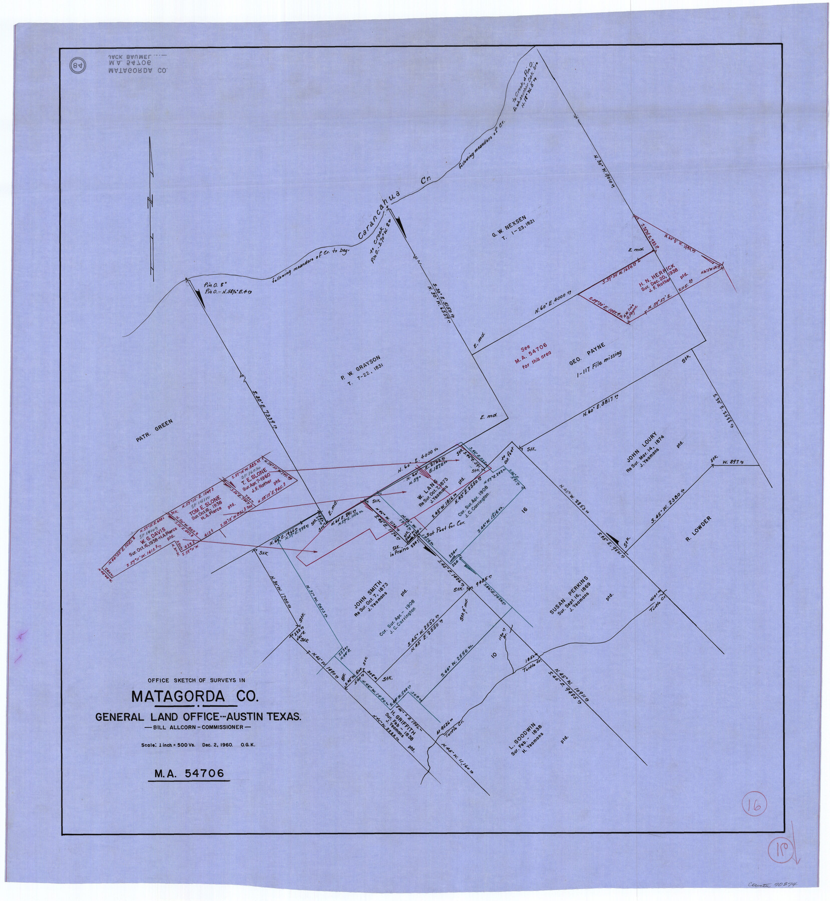
Matagorda County Working Sketch 16
-
Map/Doc
70874
-
Collection
General Map Collection
-
Object Dates
12/2/1960 (Creation Date)
-
People and Organizations
Otto G. Kurio (Draftsman)
-
Counties
Matagorda
-
Subjects
Surveying Working Sketch
-
Height x Width
34.6 x 31.8 inches
87.9 x 80.8 cm
-
Scale
1" = 500 varas
Part of: General Map Collection
Winkler County Rolled Sketch 10

Print $40.00
- Digital $50.00
Winkler County Rolled Sketch 10
1958
Size 29.4 x 55.9 inches
Map/Doc 10151
Bexar County Sketch File 14

Print $4.00
- Digital $50.00
Bexar County Sketch File 14
1855
Size 7.8 x 8.2 inches
Map/Doc 14482
Sutton County Rolled Sketch 46

Print $20.00
- Digital $50.00
Sutton County Rolled Sketch 46
1929
Size 19.4 x 15.6 inches
Map/Doc 7887
Rusk County Working Sketch 7

Print $20.00
- Digital $50.00
Rusk County Working Sketch 7
1982
Size 22.3 x 36.7 inches
Map/Doc 63642
Flight Mission No. DQN-5K, Frame 32, Calhoun County

Print $20.00
- Digital $50.00
Flight Mission No. DQN-5K, Frame 32, Calhoun County
1953
Size 16.5 x 16.3 inches
Map/Doc 84383
Waller County Working Sketch 7

Print $20.00
- Digital $50.00
Waller County Working Sketch 7
2000
Size 34.6 x 41.5 inches
Map/Doc 72306
Comal County Boundary File 1

Print $5.00
- Digital $50.00
Comal County Boundary File 1
Size 12.9 x 11.0 inches
Map/Doc 51776
Walker County Working Sketch 1

Print $20.00
- Digital $50.00
Walker County Working Sketch 1
1912
Size 20.1 x 18.4 inches
Map/Doc 72281
Kent County Working Sketch 19

Print $40.00
- Digital $50.00
Kent County Working Sketch 19
1980
Size 36.8 x 51.5 inches
Map/Doc 70026
Brewster County Rolled Sketch 109

Print $20.00
- Digital $50.00
Brewster County Rolled Sketch 109
1961
Size 19.3 x 25.3 inches
Map/Doc 5261
Baylor County Working Sketch Graphic Index

Print $20.00
- Digital $50.00
Baylor County Working Sketch Graphic Index
1961
Size 41.1 x 33.6 inches
Map/Doc 76463
Flight Mission No. DQN-2K, Frame 147, Calhoun County

Print $20.00
- Digital $50.00
Flight Mission No. DQN-2K, Frame 147, Calhoun County
1953
Size 19.0 x 22.6 inches
Map/Doc 84316
You may also like
El Paso County Working Sketch 56

Print $40.00
- Digital $50.00
El Paso County Working Sketch 56
1971
Size 65.7 x 43.4 inches
Map/Doc 69078

Austin County Working Sketch Graphic Index

Print $20.00
- Digital $50.00
Austin County Working Sketch Graphic Index
1943
Size 38.6 x 41.1 inches
Map/Doc 76459

Foard County Sketch File 9

Print $20.00
- Digital $50.00
Foard County Sketch File 9
1882
Size 19.7 x 17.1 inches
Map/Doc 11492
Map of Menard County

Print $20.00
- Digital $50.00
Map of Menard County
1898
Size 19.9 x 43.1 inches
Map/Doc 5042
Hall County Sketch File 34

Print $6.00
- Digital $50.00
Hall County Sketch File 34
1913
Size 15.1 x 9.5 inches
Map/Doc 24882
Dickens County Working Sketch 10

Print $40.00
- Digital $50.00
Dickens County Working Sketch 10
1965
Size 62.2 x 39.5 inches
Map/Doc 68658
Map of Brown County

Print $20.00
- Digital $50.00
Map of Brown County
1858
Size 25.7 x 25.3 inches
Map/Doc 3336
North end of Brazos Island

Print $20.00
- Digital $50.00
North end of Brazos Island
Size 26.0 x 18.2 inches
Map/Doc 72916
Maps of Gulf Intracoastal Waterway, Texas - Sabine River to the Rio Grande and connecting waterways including ship channels

Print $20.00
- Digital $50.00
Maps of Gulf Intracoastal Waterway, Texas - Sabine River to the Rio Grande and connecting waterways including ship channels
1966
Size 14.5 x 22.3 inches
Map/Doc 61977
Mills County Sketch File 17

Print $10.00
- Digital $50.00
Mills County Sketch File 17
1912
Size 14.4 x 8.8 inches
Map/Doc 31665