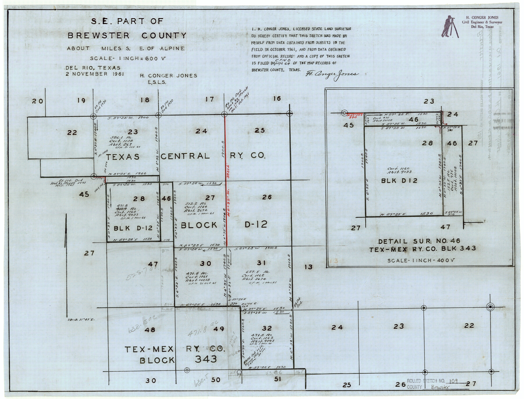
Brewster County Rolled Sketch 109
S.E. part of Brewster County
-
Map/Doc
5261
-
Collection
General Map Collection
-
Object Dates
1961/11/2 (Creation Date)
1962/1/12 (File Date)
-
People and Organizations
H. Conger Jones (Surveyor/Engineer)
-
Counties
Brewster
-
Subjects
Surveying Rolled Sketch
-
Height x Width
19.3 x 25.3 inches
49.0 x 64.3 cm
-
Medium
linen, manuscript
-
Scale
1" = 600 varas
Part of: General Map Collection
Cameron County Boundary File 4

Print $42.00
- Digital $50.00
Cameron County Boundary File 4
Size 10.4 x 8.2 inches
Map/Doc 51110
Map of Lampasas County

Print $20.00
- Digital $50.00
Map of Lampasas County
1864
Size 20.5 x 24.8 inches
Map/Doc 3793
Dickens County Sketch File 35

Print $10.00
- Digital $50.00
Dickens County Sketch File 35
1954
Size 11.2 x 8.9 inches
Map/Doc 64791
Schleicher County

Print $40.00
- Digital $50.00
Schleicher County
1940
Size 38.7 x 54.9 inches
Map/Doc 73285

Lipscomb County

Print $20.00
- Digital $50.00
Lipscomb County
1889
Size 23.5 x 18.5 inches
Map/Doc 3817
Bell County Sketch File 24

Print $4.00
- Digital $50.00
Bell County Sketch File 24
Size 10.0 x 8.0 inches
Map/Doc 14418
Hopkins County Sketch File 23

Print $4.00
- Digital $50.00
Hopkins County Sketch File 23
1871
Size 12.6 x 8.4 inches
Map/Doc 26732
Culberson County Rolled Sketch 57

Print $40.00
- Digital $50.00
Culberson County Rolled Sketch 57
1967
Size 76.9 x 44.2 inches
Map/Doc 8758
Duval County Rolled Sketch 19

Print $4.00
- Digital $50.00
Duval County Rolled Sketch 19
1940
Size 20.2 x 15.1 inches
Map/Doc 5740
Map of the Straits of Florida and Gulf of Mexico

Print $20.00
- Digital $50.00
Map of the Straits of Florida and Gulf of Mexico
1851
Size 18.4 x 27.5 inches
Map/Doc 72674
Hemphill County Rolled Sketch MJ

Print $20.00
- Digital $50.00
Hemphill County Rolled Sketch MJ
Size 21.3 x 41.4 inches
Map/Doc 6201
You may also like
Bandera County Working Sketch 41

Print $20.00
- Digital $50.00
Bandera County Working Sketch 41
1977
Size 31.3 x 37.7 inches
Map/Doc 67637
The Republic County of Bexar. January 29, 1842

Print $20.00
The Republic County of Bexar. January 29, 1842
2020
Size 14.7 x 21.7 inches
Map/Doc 96099
Flight Mission No. CRC-1R, Frame 37, Chambers County

Print $20.00
- Digital $50.00
Flight Mission No. CRC-1R, Frame 37, Chambers County
1956
Size 18.7 x 22.5 inches
Map/Doc 84705
Henderson County Boundary File 3a

Print $30.00
- Digital $50.00
Henderson County Boundary File 3a
Size 14.4 x 8.9 inches
Map/Doc 54685
Bandera County Working Sketch 20

Print $20.00
- Digital $50.00
Bandera County Working Sketch 20
1947
Size 25.4 x 19.8 inches
Map/Doc 67616
Moore County Rolled Sketch 11

Print $20.00
- Digital $50.00
Moore County Rolled Sketch 11
Size 34.1 x 43.0 inches
Map/Doc 9549
Kendall County Boundary File 54

Print $16.00
- Digital $50.00
Kendall County Boundary File 54
Size 8.6 x 3.5 inches
Map/Doc 55769
Borden County Working Sketch 16

Print $40.00
- Digital $50.00
Borden County Working Sketch 16
2007
Size 48.0 x 29.4 inches
Map/Doc 87206
[Block O1, Godair]
![90566, [Block O1, Godair], Twichell Survey Records](https://historictexasmaps.com/wmedia_w700/maps/90566-1.tif.jpg)
Print $20.00
- Digital $50.00
[Block O1, Godair]
Size 22.7 x 18.0 inches
Map/Doc 90566
Reeves County Rolled Sketch 33

Print $20.00
- Digital $50.00
Reeves County Rolled Sketch 33
Size 24.7 x 36.9 inches
Map/Doc 7501
Copy of a portion of Arista's map

Print $20.00
- Digital $50.00
Copy of a portion of Arista's map
1847
Size 27.5 x 18.3 inches
Map/Doc 73057
Upton County Rolled Sketch 36

Print $40.00
- Digital $50.00
Upton County Rolled Sketch 36
1952
Size 42.9 x 64.2 inches
Map/Doc 10051