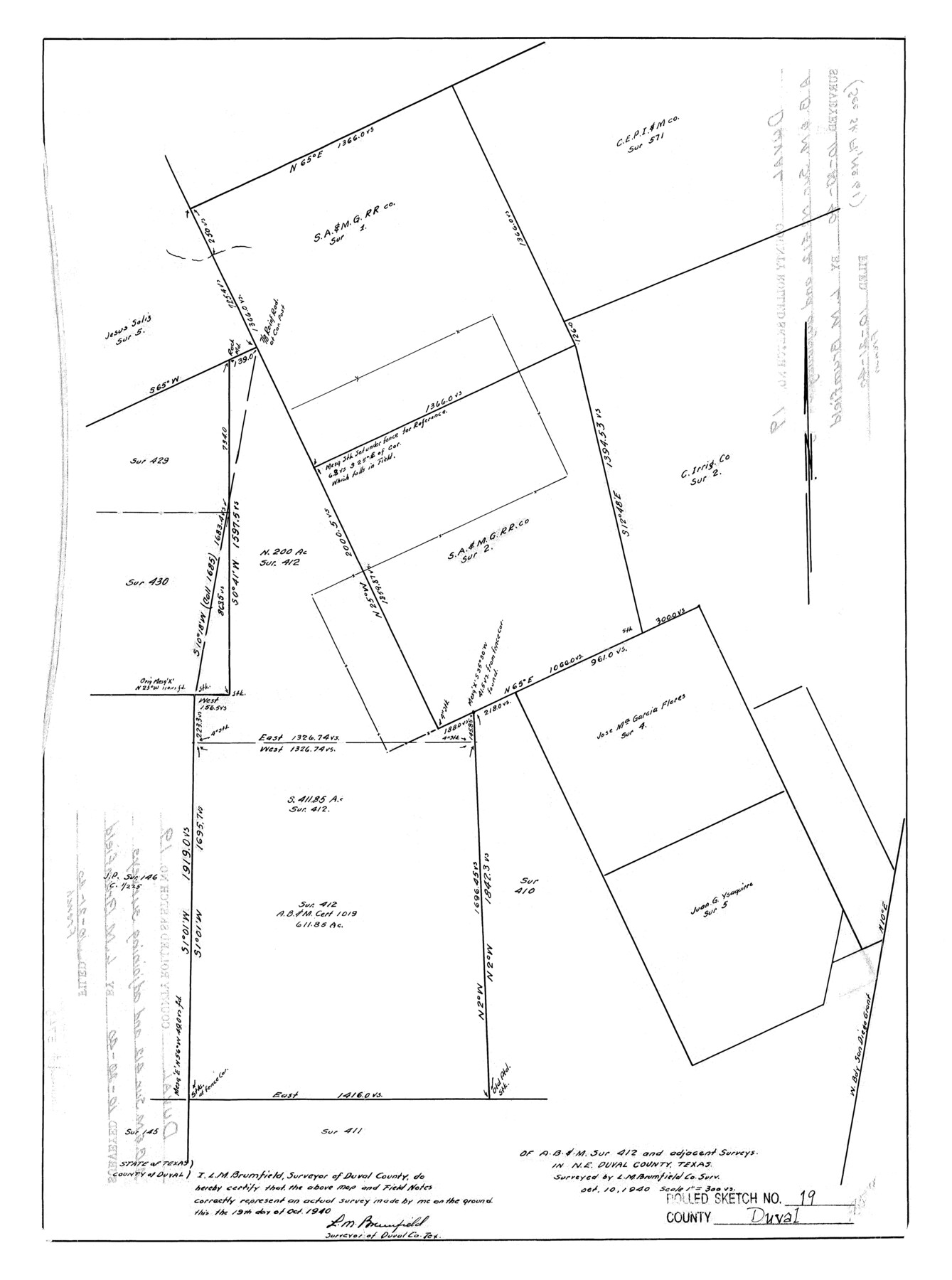
Duval County Rolled Sketch 19
[Sketch] of A. B. & M. sur. 412 and adjacent surveys in NE Duval County, Texas
-
Map/Doc
5740
-
Collection
General Map Collection
-
Object Dates
1940/10/19 (Creation Date)
1940/10/21 (File Date)
-
People and Organizations
L.M. Brumfield (Surveyor/Engineer)
-
Counties
Duval
-
Subjects
Surveying Rolled Sketch
-
Height x Width
20.2 x 15.1 inches
51.3 x 38.4 cm
-
Scale
1" = 300 varas
Part of: General Map Collection
Webb County Sketch File 2

Print $20.00
- Digital $50.00
Webb County Sketch File 2
Size 20.0 x 18.2 inches
Map/Doc 12612
Flight Mission No. DQN-1K, Frame 139, Calhoun County

Print $20.00
- Digital $50.00
Flight Mission No. DQN-1K, Frame 139, Calhoun County
1953
Size 18.4 x 22.3 inches
Map/Doc 84202
Dallas County Boundary File 8 and 8a

Print $16.00
- Digital $50.00
Dallas County Boundary File 8 and 8a
Size 11.3 x 8.6 inches
Map/Doc 52304
Gaines County Rolled Sketch G3

Print $20.00
- Digital $50.00
Gaines County Rolled Sketch G3
1902
Size 22.7 x 31.4 inches
Map/Doc 5946
Franklin County Sketch File 4

Print $6.00
- Digital $50.00
Franklin County Sketch File 4
1855
Size 13.4 x 11.4 inches
Map/Doc 23015
Wilbarger County Working Sketch 7a and 7b

Print $20.00
- Digital $50.00
Wilbarger County Working Sketch 7a and 7b
1951
Size 22.7 x 24.0 inches
Map/Doc 72545
Harris County Working Sketch Graphic Index, Sheet 2 (Sketches 69 to Most Recent)

Print $20.00
- Digital $50.00
Harris County Working Sketch Graphic Index, Sheet 2 (Sketches 69 to Most Recent)
1940
Size 38.5 x 46.2 inches
Map/Doc 76569
Flight Mission No. DCL-7C, Frame 51, Kenedy County

Print $20.00
- Digital $50.00
Flight Mission No. DCL-7C, Frame 51, Kenedy County
1943
Size 16.6 x 16.4 inches
Map/Doc 86039
Hardin County Working Sketch 38

Print $20.00
- Digital $50.00
Hardin County Working Sketch 38
1981
Size 37.2 x 19.4 inches
Map/Doc 63436
Panola County Sketch File 5

Print $4.00
- Digital $50.00
Panola County Sketch File 5
1860
Size 8.3 x 5.6 inches
Map/Doc 33453
Shelby County Rolled Sketch 9

Print $20.00
- Digital $50.00
Shelby County Rolled Sketch 9
Size 23.0 x 19.1 inches
Map/Doc 7777
Upton County Working Sketch 54

Print $20.00
- Digital $50.00
Upton County Working Sketch 54
1983
Size 23.2 x 37.7 inches
Map/Doc 69551
You may also like
[Sketch for Mineral Application 17237 / Mineral File 11855 - Neches River, Joe A. Sanders]
![2819, [Sketch for Mineral Application 17237 / Mineral File 11855 - Neches River, Joe A. Sanders], General Map Collection](https://historictexasmaps.com/wmedia_w700/maps/2819.tif.jpg)
Print $2.00
- Digital $50.00
[Sketch for Mineral Application 17237 / Mineral File 11855 - Neches River, Joe A. Sanders]
1927
Size 12.8 x 8.2 inches
Map/Doc 2819
Val Verde County Sketch File XXX5

Print $40.00
- Digital $50.00
Val Verde County Sketch File XXX5
Size 13.2 x 13.4 inches
Map/Doc 39100
San Patricio County Rolled Sketch 17A

Print $20.00
- Digital $50.00
San Patricio County Rolled Sketch 17A
1917
Size 15.7 x 23.8 inches
Map/Doc 7575
Nueces County Sketch File 33

Print $20.00
- Digital $50.00
Nueces County Sketch File 33
1908
Size 22.0 x 19.2 inches
Map/Doc 42188
Karnes County Sketch File 7a

Print $4.00
- Digital $50.00
Karnes County Sketch File 7a
1873
Size 10.1 x 8.1 inches
Map/Doc 28563
Jeff Davis County Rolled Sketch T4

Print $20.00
- Digital $50.00
Jeff Davis County Rolled Sketch T4
Size 28.9 x 23.9 inches
Map/Doc 6382
PSL Field Notes for Blocks 110 through 122 in Culberson County and Block 123 in Hudspeth County

PSL Field Notes for Blocks 110 through 122 in Culberson County and Block 123 in Hudspeth County
Map/Doc 81666
Gonzales County Working Sketch Graphic Index

Print $40.00
- Digital $50.00
Gonzales County Working Sketch Graphic Index
1986
Size 40.2 x 53.0 inches
Map/Doc 76556
Flight Mission No. DQO-1K, Frame 147, Galveston County

Print $20.00
- Digital $50.00
Flight Mission No. DQO-1K, Frame 147, Galveston County
1952
Size 18.8 x 22.4 inches
Map/Doc 85000
[Sketch of Blocks 4X, E, T, C42, and Y with Double Lake Corner tie to Rhoads Fisher Corners]
![91940, [Sketch of Blocks 4X, E, T, C42, and Y with Double Lake Corner tie to Rhoads Fisher Corners], Twichell Survey Records](https://historictexasmaps.com/wmedia_w700/maps/91940-2.tif.jpg)
Print $20.00
- Digital $50.00
[Sketch of Blocks 4X, E, T, C42, and Y with Double Lake Corner tie to Rhoads Fisher Corners]
Size 34.0 x 11.5 inches
Map/Doc 91940
Revised Sectional Map Number 2, Showing Lands in Howard, Martin, Andrews, Glasscock, Midland, Ector, and Portions of Borden, Dawson, Irion, Reagan, Upton, Crane, Ward, and Winkler Counties

Print $20.00
- Digital $50.00
Revised Sectional Map Number 2, Showing Lands in Howard, Martin, Andrews, Glasscock, Midland, Ector, and Portions of Borden, Dawson, Irion, Reagan, Upton, Crane, Ward, and Winkler Counties
1908
Size 16.6 x 13.3 inches
Map/Doc 91113
Trinity County Working Sketch 17

Print $20.00
- Digital $50.00
Trinity County Working Sketch 17
1978
Size 24.0 x 26.6 inches
Map/Doc 69466