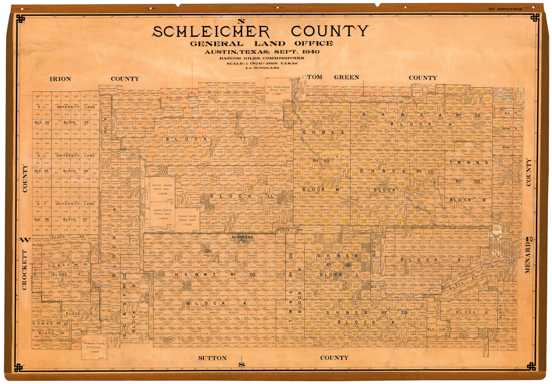
Schleicher County
-
Map/Doc
73285
-
Collection
General Map Collection
-
Object Dates
1940 (Creation Date)
-
People and Organizations
Texas General Land Office (Publisher)
Eltea Armstrong (Draftsman)
Bascom Giles (GLO Commissioner)
J.L. Woodland (Compiler)
-
Counties
Schleicher
-
Subjects
County
-
Height x Width
38.7 x 54.9 inches
98.3 x 139.4 cm
-
Comments
Hand lettered.
Note on reverse side: "Replaced (on sticks) by copy June 20, 1946." -
Features
Ten Mile Creek
P&SF
Eight Mile Creek
East Poor Hollow Creek
West Poor Hollow Cree
North Valley Prong of San Saba River
Eldorado
Buckhorn Draw
Terrett Creek
Middle Valley Prong of San Saba River
Part of: General Map Collection
Flight Mission No. DQN-1K, Frame 104, Calhoun County

Print $20.00
- Digital $50.00
Flight Mission No. DQN-1K, Frame 104, Calhoun County
1953
Size 18.4 x 22.1 inches
Map/Doc 84171
Coryell County

Print $20.00
- Digital $50.00
Coryell County
1880
Size 25.6 x 25.6 inches
Map/Doc 3444
Pecos County Sketch File 25

Print $20.00
- Digital $50.00
Pecos County Sketch File 25
Size 17.6 x 24.9 inches
Map/Doc 12164
El Paso County Sketch File 1

Print $48.00
- Digital $50.00
El Paso County Sketch File 1
1849
Size 8.9 x 8.2 inches
Map/Doc 21883
Gray County Working Sketch 5

Print $20.00
- Digital $50.00
Gray County Working Sketch 5
1959
Size 28.6 x 27.5 inches
Map/Doc 63236
Montague County Sketch File 7

Print $6.00
- Digital $50.00
Montague County Sketch File 7
1860
Size 6.3 x 5.4 inches
Map/Doc 31719
Bailey County Sketch File 19

Print $8.00
- Digital $50.00
Bailey County Sketch File 19
1882
Size 13.2 x 8.4 inches
Map/Doc 13987
East Part of Liberty Co.

Print $20.00
- Digital $50.00
East Part of Liberty Co.
1977
Size 47.9 x 36.9 inches
Map/Doc 95569
Leon County Working Sketch 20

Print $20.00
- Digital $50.00
Leon County Working Sketch 20
1963
Size 37.8 x 38.2 inches
Map/Doc 70419
Flight Mission No. CRK-5P, Frame 130, Refugio County

Print $20.00
- Digital $50.00
Flight Mission No. CRK-5P, Frame 130, Refugio County
1956
Size 18.6 x 22.5 inches
Map/Doc 86933
Donley County Working Sketch 6

Print $20.00
- Digital $50.00
Donley County Working Sketch 6
1965
Size 34.3 x 42.2 inches
Map/Doc 68739
Borden County Sketch File 3b

Print $40.00
- Digital $50.00
Borden County Sketch File 3b
1902
Size 9.5 x 21.1 inches
Map/Doc 10933
You may also like
Brewster County Rolled Sketch 60

Print $40.00
- Digital $50.00
Brewster County Rolled Sketch 60
Size 37.1 x 68.9 inches
Map/Doc 8485
[West line of B. & B. Block 1]
![90584, [West line of B. & B. Block 1], Twichell Survey Records](https://historictexasmaps.com/wmedia_w700/maps/90584-1.tif.jpg)
Print $20.00
- Digital $50.00
[West line of B. & B. Block 1]
Size 12.7 x 15.2 inches
Map/Doc 90584
Henderson County Sketch File 21

Print $20.00
- Digital $50.00
Henderson County Sketch File 21
1941
Size 27.8 x 17.9 inches
Map/Doc 11758
The Republic County of Bowie. January 16, 1843

Print $20.00
The Republic County of Bowie. January 16, 1843
2020
Size 19.5 x 21.7 inches
Map/Doc 96106
Flight Mission No. DAG-16K, Frame 70, Matagorda County

Print $20.00
- Digital $50.00
Flight Mission No. DAG-16K, Frame 70, Matagorda County
1952
Size 17.3 x 17.1 inches
Map/Doc 86316
Oldham County Sketch File 3

Print $12.00
- Digital $50.00
Oldham County Sketch File 3
1883
Size 8.2 x 7.8 inches
Map/Doc 33228
Coleman County Working Sketch 3

Print $20.00
- Digital $50.00
Coleman County Working Sketch 3
1918
Size 27.1 x 29.2 inches
Map/Doc 68069
Plat of 83.94 acre vacant tract of land showing connections to adjoining surveys

Print $20.00
- Digital $50.00
Plat of 83.94 acre vacant tract of land showing connections to adjoining surveys
1918
Size 17.7 x 21.1 inches
Map/Doc 90823
[Blocks and surveys to the North and West of Jasper County School Land]
![91570, [Blocks and surveys to the North and West of Jasper County School Land], Twichell Survey Records](https://historictexasmaps.com/wmedia_w700/maps/91570-1.tif.jpg)
Print $20.00
- Digital $50.00
[Blocks and surveys to the North and West of Jasper County School Land]
Size 14.9 x 17.8 inches
Map/Doc 91570
Starr County Working Sketch 29

Print $20.00
- Digital $50.00
Starr County Working Sketch 29
2007
Size 28.6 x 34.0 inches
Map/Doc 87208
Edwards County Working Sketch 13

Print $20.00
- Digital $50.00
Edwards County Working Sketch 13
1922
Size 18.3 x 18.4 inches
Map/Doc 68889
Flight Mission No. BQY-1T, Frame 74, Harris County

Print $20.00
- Digital $50.00
Flight Mission No. BQY-1T, Frame 74, Harris County
1957
Size 17.5 x 17.6 inches
Map/Doc 85294