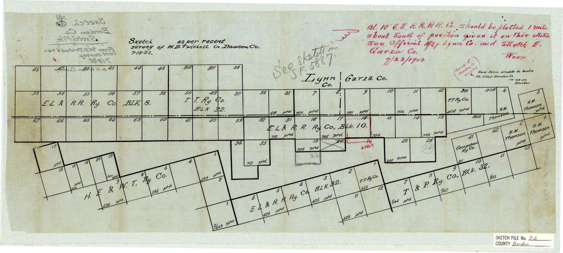
Borden County Sketch File 3b
[Sketch of area in northwest part of county]
-
Map/Doc
10933
-
Collection
General Map Collection
-
Object Dates
1902/7/18 (Creation Date)
-
People and Organizations
W.D. Twichell (Surveyor/Engineer)
-
Counties
Borden Garza Lynn
-
Subjects
Surveying Sketch File
-
Height x Width
9.5 x 21.1 inches
24.1 x 53.6 cm
-
Medium
linen, manuscript
Part of: General Map Collection
Upton County Sketch File 21

Print $20.00
- Digital $50.00
Upton County Sketch File 21
1927
Size 15.0 x 23.7 inches
Map/Doc 12518
Index sheet to accompany map of survey for connecting the inland waters along margin of the Gulf of Mexico from Donaldsonville in Louisiana to the Rio Grande River in Texas

Print $20.00
- Digital $50.00
Index sheet to accompany map of survey for connecting the inland waters along margin of the Gulf of Mexico from Donaldsonville in Louisiana to the Rio Grande River in Texas
Size 18.2 x 27.4 inches
Map/Doc 72690
Map of the Southwest Railway System

Print $20.00
- Digital $50.00
Map of the Southwest Railway System
1883
Size 16.0 x 28.8 inches
Map/Doc 93287
Map of Polk County

Print $20.00
- Digital $50.00
Map of Polk County
1856
Size 22.1 x 23.7 inches
Map/Doc 3961
Real County Sketch File 14

Print $20.00
- Digital $50.00
Real County Sketch File 14
1933
Size 16.5 x 16.7 inches
Map/Doc 12233
Fractional Township No. 8 South Range No. 6 East of the Indian Meridian, Indian Territory

Print $20.00
- Digital $50.00
Fractional Township No. 8 South Range No. 6 East of the Indian Meridian, Indian Territory
1898
Size 19.3 x 24.4 inches
Map/Doc 75210
Brazoria County Sketch File 15a

Print $4.00
- Digital $50.00
Brazoria County Sketch File 15a
1892
Size 14.2 x 8.7 inches
Map/Doc 14979
Galveston County Boundary File 32

Print $52.00
- Digital $50.00
Galveston County Boundary File 32
Size 16.7 x 13.6 inches
Map/Doc 53658
Flight Mission No. DQN-2K, Frame 115, Calhoun County

Print $20.00
- Digital $50.00
Flight Mission No. DQN-2K, Frame 115, Calhoun County
1953
Size 18.6 x 22.3 inches
Map/Doc 84291
Galveston County NRC Article 33.136 Sketch 94

Print $72.00
Galveston County NRC Article 33.136 Sketch 94
2024
Map/Doc 97293
Van Zandt County Working Sketch 6a

Print $40.00
- Digital $50.00
Van Zandt County Working Sketch 6a
1941
Size 57.6 x 30.1 inches
Map/Doc 72255
Tom Green County Sketch File 50

Print $20.00
- Digital $50.00
Tom Green County Sketch File 50
1884
Size 25.4 x 34.5 inches
Map/Doc 12442
You may also like
The Republic County of Goliad. 1840

Print $20.00
The Republic County of Goliad. 1840
2020
Size 15.1 x 21.7 inches
Map/Doc 96150
Newton County Rolled Sketch 18

Print $40.00
- Digital $50.00
Newton County Rolled Sketch 18
1955
Size 41.6 x 59.2 inches
Map/Doc 9580
Victoria County Sketch File 2

Print $7.00
- Digital $50.00
Victoria County Sketch File 2
1873
Size 10.3 x 8.4 inches
Map/Doc 39511
America's Fun-Tier: Texas 1965 Official Highway Travel Map

Digital $50.00
America's Fun-Tier: Texas 1965 Official Highway Travel Map
Size 28.2 x 36.4 inches
Map/Doc 94325
Provincias internas del reyno de Nuevo España

Print $20.00
Provincias internas del reyno de Nuevo España
1846
Size 30.7 x 23.6 inches
Map/Doc 93578
Van Zandt County Sketch File 20a

Print $4.00
- Digital $50.00
Van Zandt County Sketch File 20a
1858
Size 12.9 x 8.0 inches
Map/Doc 39428
Sketch Showing surveys on Harbor Island in Nueces County

Print $20.00
- Digital $50.00
Sketch Showing surveys on Harbor Island in Nueces County
1951
Size 45.7 x 34.6 inches
Map/Doc 1915
Map of the Colonization Grants to Zavala, Vehlein & Burnet in Texas, belonging to the Galveston Bay & Texas Land Co.

Print $20.00
- Digital $50.00
Map of the Colonization Grants to Zavala, Vehlein & Burnet in Texas, belonging to the Galveston Bay & Texas Land Co.
1835
Size 10.7 x 12.7 inches
Map/Doc 93851
Brewster County Rolled Sketch 33

Print $20.00
- Digital $50.00
Brewster County Rolled Sketch 33
1906
Size 20.5 x 29.0 inches
Map/Doc 5217
Martin County Boundary File 2

Print $32.00
- Digital $50.00
Martin County Boundary File 2
Size 9.3 x 9.1 inches
Map/Doc 56760
Nueces County Sketch File 11

Print $40.00
- Digital $50.00
Nueces County Sketch File 11
1859
Size 11.2 x 8.6 inches
Map/Doc 32518
Jefferson County Rolled Sketch 4

Print $40.00
- Digital $50.00
Jefferson County Rolled Sketch 4
Size 36.7 x 65.3 inches
Map/Doc 9269