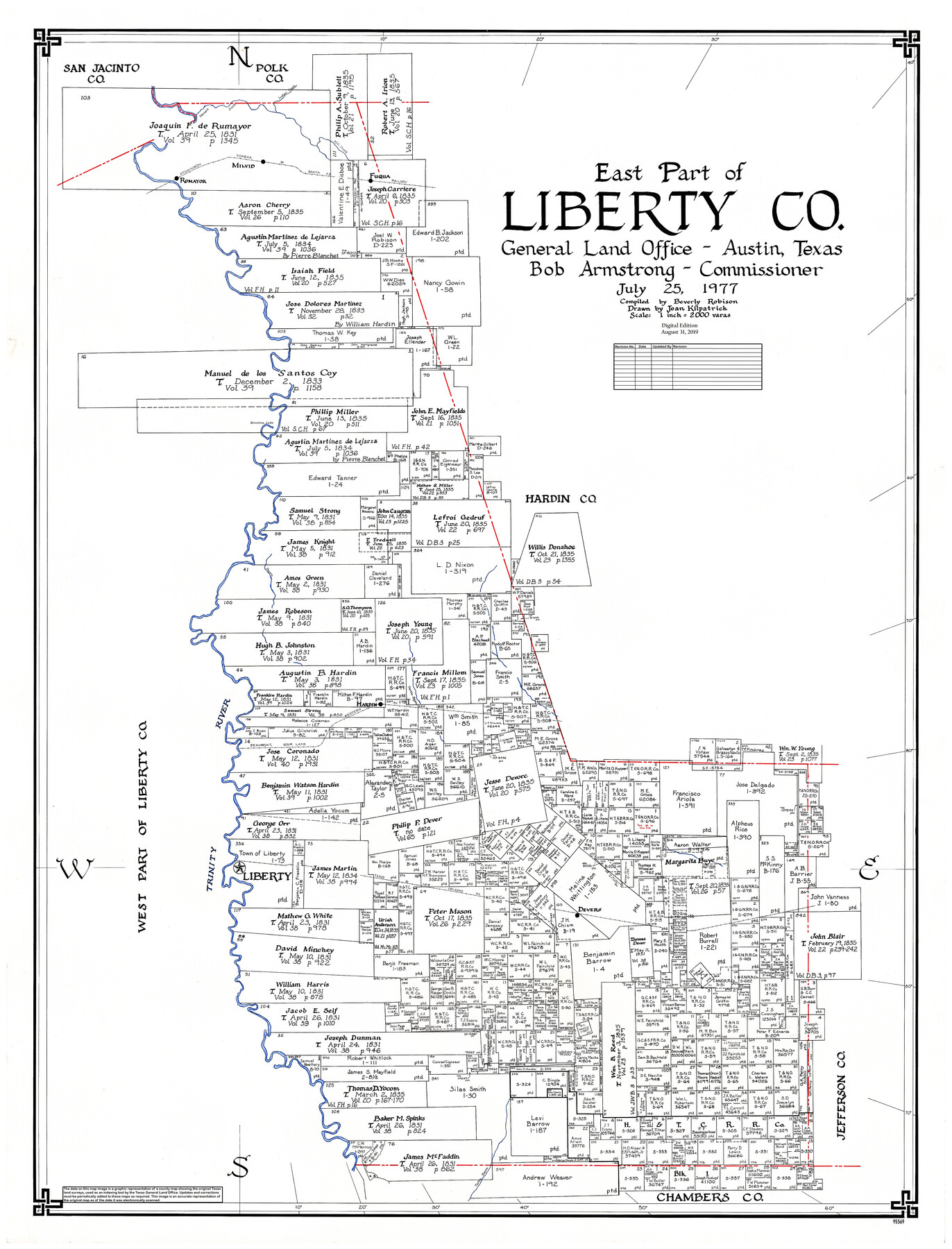
East Part of Liberty Co.
General Land Office Official County Map
-
Map/Doc
95569
-
Collection
General Map Collection
-
Object Dates
2019/8/31 (Revision Date)
1977/7/25 (Creation Date)
-
People and Organizations
Cheyenne Betancourt (Draftsman)
Joan Kilpatrick (Draftsman)
Beverly Robison (Compiler)
Bob Armstrong (GLO Commissioner)
-
Counties
Liberty
-
Subjects
County OCM
-
Height x Width
47.9 x 36.9 inches
121.7 x 93.7 cm
-
Medium
digital image
-
Scale
1" = 2000 varas
-
Comments
For west part of Liberty County, see 95570.
Related maps
West Part of Liberty Co.

Print $40.00
- Digital $50.00
West Part of Liberty Co.
1977
Size 48.0 x 36.9 inches
Map/Doc 95570
Part of: General Map Collection
Zapata County Rolled Sketch 12A

Print $40.00
- Digital $50.00
Zapata County Rolled Sketch 12A
1917
Size 54.0 x 40.0 inches
Map/Doc 10165
Nueces County Rolled Sketch 37

Print $20.00
- Digital $50.00
Nueces County Rolled Sketch 37
1950
Size 22.5 x 33.3 inches
Map/Doc 6878
Brown County Sketch File 30

Print $27.00
- Digital $50.00
Brown County Sketch File 30
1924
Size 12.7 x 11.0 inches
Map/Doc 16631
Pecos County Working Sketch 116

Print $40.00
- Digital $50.00
Pecos County Working Sketch 116
1973
Size 52.3 x 37.2 inches
Map/Doc 71589
Garza County Sketch File 25

Print $4.00
- Digital $50.00
Garza County Sketch File 25
1907
Size 7.6 x 7.9 inches
Map/Doc 24086
Galveston County NRC Article 33.136 Sketch 92

Print $62.00
Galveston County NRC Article 33.136 Sketch 92
2021
Map/Doc 97179
La Salle County Rolled Sketch 18

Print $20.00
- Digital $50.00
La Salle County Rolled Sketch 18
Size 29.8 x 20.6 inches
Map/Doc 6582
Cochran County Sketch File 8

Print $32.00
- Digital $50.00
Cochran County Sketch File 8
1940
Size 11.0 x 8.8 inches
Map/Doc 18555
Flight Mission No. DCL-3C, Frame 156, Kenedy County

Print $20.00
- Digital $50.00
Flight Mission No. DCL-3C, Frame 156, Kenedy County
1943
Size 18.5 x 22.3 inches
Map/Doc 85804
Bell County Sketch File 29

Print $4.00
- Digital $50.00
Bell County Sketch File 29
1874
Size 13.1 x 8.1 inches
Map/Doc 14439
Map of Andrews County

Print $40.00
- Digital $50.00
Map of Andrews County
1900
Size 40.8 x 52.9 inches
Map/Doc 4780
Grayson County Working Sketch 19

Print $20.00
- Digital $50.00
Grayson County Working Sketch 19
1956
Size 40.0 x 29.0 inches
Map/Doc 63258
You may also like
Map of Surveys Made for the T&PRRCo in Tom Green & Martin Counties, Blocks 40, 41, 42, 43, 44, 45 & 46, Reserve West of the Colorado

Print $20.00
- Digital $50.00
Map of Surveys Made for the T&PRRCo in Tom Green & Martin Counties, Blocks 40, 41, 42, 43, 44, 45 & 46, Reserve West of the Colorado
1876
Size 42.3 x 46.0 inches
Map/Doc 2227
Culberson County Working Sketch 9

Print $20.00
- Digital $50.00
Culberson County Working Sketch 9
1915
Size 41.5 x 35.9 inches
Map/Doc 68461
Flight Mission No. BRA-8M, Frame 113, Jefferson County

Print $20.00
- Digital $50.00
Flight Mission No. BRA-8M, Frame 113, Jefferson County
1953
Size 18.6 x 22.3 inches
Map/Doc 85609
[Bastrop District]
![83006, [Bastrop District], General Map Collection](https://historictexasmaps.com/wmedia_w700/maps/83006-1.tif.jpg)
Print $40.00
- Digital $50.00
[Bastrop District]
1895
Size 71.8 x 52.3 inches
Map/Doc 83006
The Mexican Department of Brazos. Created, March 18, 1834

Print $20.00
The Mexican Department of Brazos. Created, March 18, 1834
2020
Size 19.7 x 21.7 inches
Map/Doc 95975
Hemphill County Rolled Sketch 17

Print $20.00
- Digital $50.00
Hemphill County Rolled Sketch 17
1965
Size 27.8 x 36.1 inches
Map/Doc 6197
Flight Mission No. BRA-8M, Frame 76, Jefferson County

Print $20.00
- Digital $50.00
Flight Mission No. BRA-8M, Frame 76, Jefferson County
1953
Size 18.5 x 22.3 inches
Map/Doc 85596
Val Verde County Working Sketch 119

Print $40.00
- Digital $50.00
Val Verde County Working Sketch 119
2005
Size 30.5 x 50.0 inches
Map/Doc 83588
Flight Mission No. DCL-6C, Frame 128, Kenedy County

Print $20.00
- Digital $50.00
Flight Mission No. DCL-6C, Frame 128, Kenedy County
1943
Size 18.6 x 22.3 inches
Map/Doc 85958
Texas Official Highway Travel Map

Digital $50.00
Texas Official Highway Travel Map
Size 27.1 x 36.2 inches
Map/Doc 94311
Flight Mission No. CLL-1N, Frame 15, Willacy County

Print $20.00
- Digital $50.00
Flight Mission No. CLL-1N, Frame 15, Willacy County
1954
Size 18.4 x 22.1 inches
Map/Doc 87002
Rusk County Working Sketch 22

Print $20.00
- Digital $50.00
Rusk County Working Sketch 22
1950
Size 22.5 x 12.8 inches
Map/Doc 63658