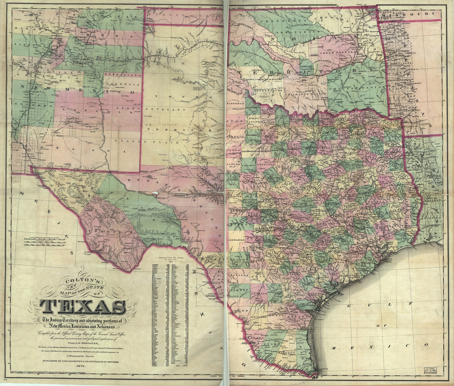
Colton's new map of the state of Texas, the Indian Territory and adjoining portions of New Mexico, Louisiana, and Arkansas
-
Map/Doc
93579
-
Collection
Library of Congress
-
Object Dates
1872 (Creation Date)
-
People and Organizations
G.W. & C.B. Colton & Co. (Publisher)
G. Woolworth Colton (Author)
-
Subjects
State of Texas
-
Height x Width
31.1 x 36.6 inches
79.0 x 93.0 cm
-
Comments
For more information see here. Prints available from the GLO courtesy of Library of Congress, Geography and Map Division.
Part of: Library of Congress


Corpus Christi and Rio Grande Railway Company

Print $20.00
Corpus Christi and Rio Grande Railway Company
Size 14.6 x 24.0 inches
Map/Doc 95314
Map of South Pacific Rail Road Co. of Missouri.

Print $20.00
Map of South Pacific Rail Road Co. of Missouri.
1870
Size 13.4 x 15.7 inches
Map/Doc 93613


Perspective Map of Texarkana, Texas and Arkansas

Print $20.00
Perspective Map of Texarkana, Texas and Arkansas
1888
Size 18.1 x 29.2 inches
Map/Doc 93485

Map of the County of Galveston

Print $20.00
Map of the County of Galveston
1902
Size 18.5 x 26.4 inches
Map/Doc 93584
Map of the city of Fort Worth and vicinity

Print $20.00
Map of the city of Fort Worth and vicinity
Size 38.6 x 25.9 inches
Map/Doc 93557


You may also like
[Pencil sketch of Wm. Rivers survey]
![91968, [Pencil sketch of Wm. Rivers survey], Twichell Survey Records](https://historictexasmaps.com/wmedia_w700/maps/91968-1.tif.jpg)
Print $3.00
- Digital $50.00
[Pencil sketch of Wm. Rivers survey]
Size 10.1 x 16.5 inches
Map/Doc 91968
Garza County Sketch File E1

Print $8.00
- Digital $50.00
Garza County Sketch File E1
1901
Size 11.2 x 8.8 inches
Map/Doc 24022

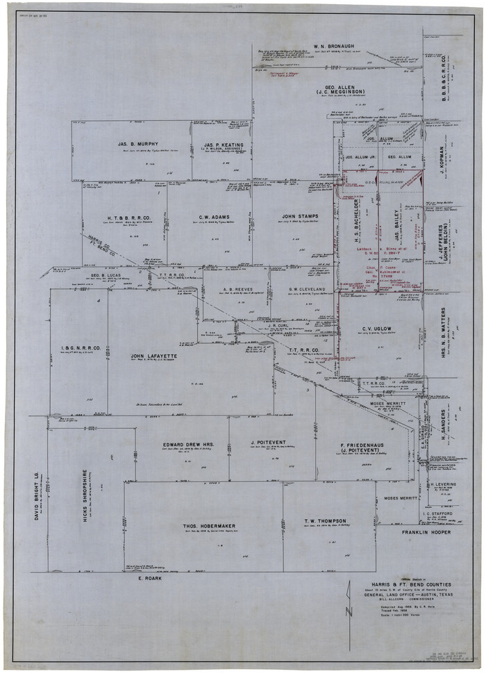
Harris County Rolled Sketch 82
Print $40.00
- Digital $50.00
Harris County Rolled Sketch 82
1956
Size 50.5 x 36.4 inches
Map/Doc 9138
Events of the Texas Revolution

Events of the Texas Revolution
2023
Size 11.0 x 17.0 inches
Map/Doc 97194
The Judicial District/County of Burleson. Created, January 15, 1842

Print $20.00
The Judicial District/County of Burleson. Created, January 15, 1842
2020
Size 14.1 x 21.7 inches
Map/Doc 96320
[Surveys in Bexar County]
![93, [Surveys in Bexar County], General Map Collection](https://historictexasmaps.com/wmedia_w700/maps/93.tif.jpg)
Print $2.00
- Digital $50.00
[Surveys in Bexar County]
Size 11.3 x 6.9 inches
Map/Doc 93
Harris County Working Sketch 61

Print $20.00
- Digital $50.00
Harris County Working Sketch 61
1954
Size 22.2 x 24.3 inches
Map/Doc 65953
A Map of California with Descriptive Notes

A Map of California with Descriptive Notes
1954
Size 29.5 x 37.6 inches
Map/Doc 92394
Flight Mission No. BRA-8M, Frame 64, Jefferson County

Print $20.00
- Digital $50.00
Flight Mission No. BRA-8M, Frame 64, Jefferson County
1953
Size 18.5 x 22.3 inches
Map/Doc 85584
Brazoria County Working Sketch 22

Print $20.00
- Digital $50.00
Brazoria County Working Sketch 22
1959
Size 27.0 x 25.3 inches
Map/Doc 67507
Coleman County Sketch File A1

Print $6.00
- Digital $50.00
Coleman County Sketch File A1
Size 5.4 x 7.7 inches
Map/Doc 18664