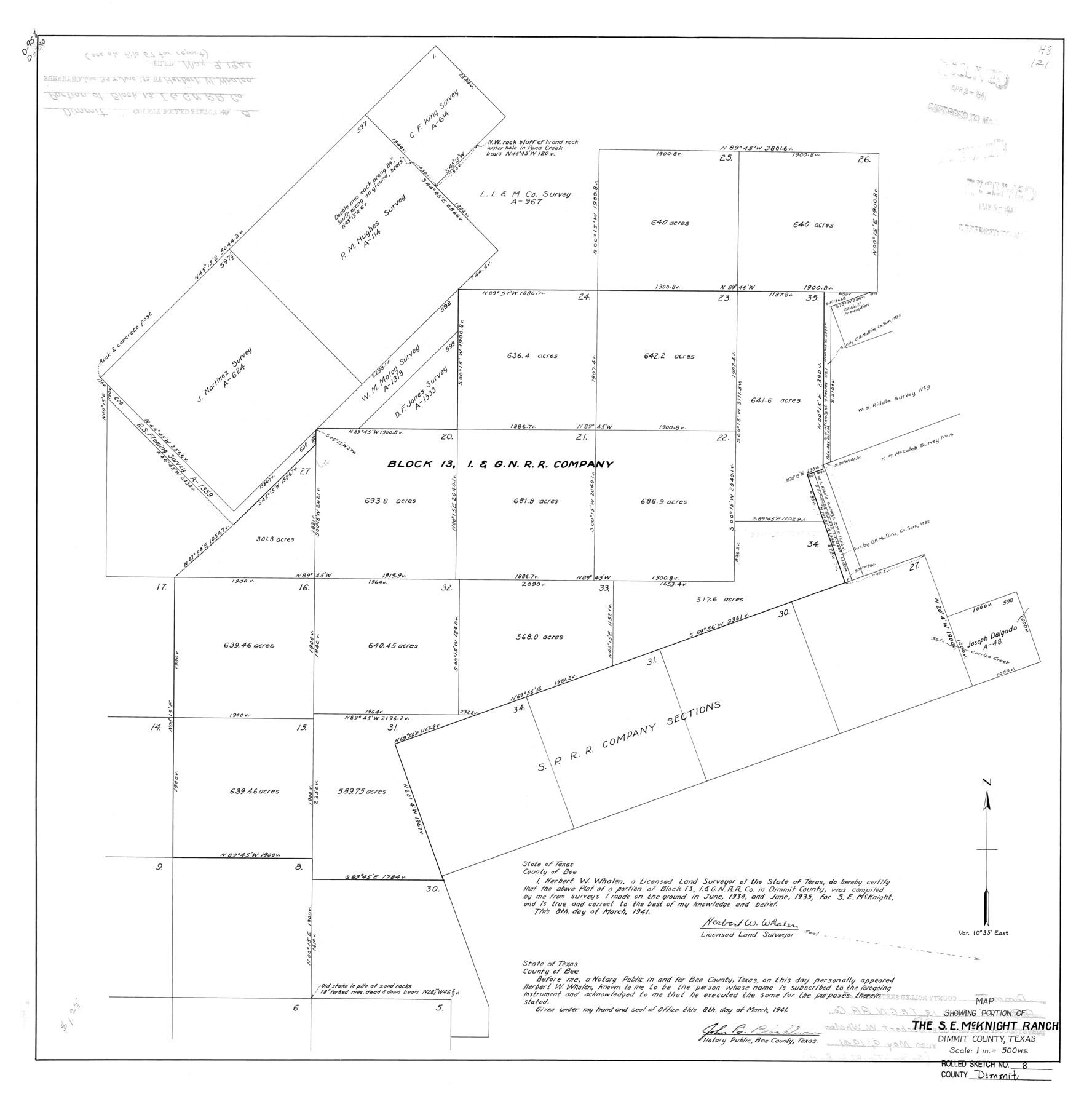
Dimmit County Rolled Sketch 8
Map showing portion of the S.E. McKnight Ranch, Dimmit County, Texas
-
Map/Doc
5718
-
Collection
General Map Collection
-
Object Dates
1941/3/8 (Creation Date)
1941/5/9 (File Date)
-
People and Organizations
Herbert W. Whalen (Surveyor/Engineer)
-
Counties
Dimmit
-
Subjects
Surveying Rolled Sketch
-
Height x Width
30.0 x 29.6 inches
76.2 x 75.2 cm
-
Scale
1" = 500 varas
-
Comments
See Dimmit County Sketch File 57 (21190) for report.
Related maps
Dimmit County Sketch File 57

Print $6.00
- Digital $50.00
Dimmit County Sketch File 57
1941
Size 14.3 x 8.8 inches
Map/Doc 21190
Part of: General Map Collection
Garza County Rolled Sketch 6D

Print $20.00
- Digital $50.00
Garza County Rolled Sketch 6D
1913
Size 17.4 x 16.0 inches
Map/Doc 5998
Flight Mission No. BRA-6M, Frame 75, Jefferson County

Print $20.00
- Digital $50.00
Flight Mission No. BRA-6M, Frame 75, Jefferson County
1953
Size 18.8 x 22.5 inches
Map/Doc 85419
Map of Duval County

Print $20.00
- Digital $50.00
Map of Duval County
1876
Size 29.6 x 21.5 inches
Map/Doc 3498
Grayson County Rolled Sketch 1

Print $20.00
- Digital $50.00
Grayson County Rolled Sketch 1
1944
Size 43.4 x 29.0 inches
Map/Doc 6029
Edwards County Sketch File 54

Print $20.00
- Digital $50.00
Edwards County Sketch File 54
Size 17.9 x 18.4 inches
Map/Doc 11447
Hale County Working Sketch 5

Print $20.00
- Digital $50.00
Hale County Working Sketch 5
1980
Size 15.0 x 11.1 inches
Map/Doc 63325
Map of Ferrocarriles Nacionales de Mexico (National Railways of Mexico), Interoceanic Railway of Mexico, Vera Cruz to Isthmus Railroad, Pan-American Railroad, Texas-Mexican Railway

Print $20.00
- Digital $50.00
Map of Ferrocarriles Nacionales de Mexico (National Railways of Mexico), Interoceanic Railway of Mexico, Vera Cruz to Isthmus Railroad, Pan-American Railroad, Texas-Mexican Railway
1911
Size 9.4 x 16.1 inches
Map/Doc 95744
Sterling County Rolled Sketch 37

Print $20.00
- Digital $50.00
Sterling County Rolled Sketch 37
Size 13.7 x 16.6 inches
Map/Doc 7862
Houston Ship Channel, Atkinson Island to Alexander Island

Print $40.00
- Digital $50.00
Houston Ship Channel, Atkinson Island to Alexander Island
1975
Size 36.2 x 50.4 inches
Map/Doc 69903
Collin County Rolled Sketch 1

Print $20.00
- Digital $50.00
Collin County Rolled Sketch 1
1953
Size 34.9 x 35.6 inches
Map/Doc 8635
Hemphill County Rolled Sketch 2

Print $20.00
- Digital $50.00
Hemphill County Rolled Sketch 2
Size 26.4 x 29.8 inches
Map/Doc 6185
Bandera County Boundary File 4a

Print $32.00
- Digital $50.00
Bandera County Boundary File 4a
Size 13.3 x 8.7 inches
Map/Doc 50276
You may also like
Harris County Historic Topographic 2

Print $20.00
- Digital $50.00
Harris County Historic Topographic 2
1916
Size 29.5 x 22.7 inches
Map/Doc 65812
Dawson County Sketch File 21

Print $20.00
- Digital $50.00
Dawson County Sketch File 21
1953
Size 12.2 x 24.5 inches
Map/Doc 11297
Runnels County Working Sketch 23

Print $20.00
- Digital $50.00
Runnels County Working Sketch 23
1953
Size 34.7 x 31.4 inches
Map/Doc 63619
[Adams Beaty & Moulton Block 2] / Map of Heller's Addition to Canyon City
![92121, [Adams Beaty & Moulton Block 2] / Map of Heller's Addition to Canyon City, Twichell Survey Records](https://historictexasmaps.com/wmedia_w700/maps/92121-1.tif.jpg)
Print $20.00
- Digital $50.00
[Adams Beaty & Moulton Block 2] / Map of Heller's Addition to Canyon City
Size 23.1 x 25.2 inches
Map/Doc 92121
[Right of Way Map, Belton Branch of the M.K.&T. RR.]
![64222, [Right of Way Map, Belton Branch of the M.K.&T. RR.], General Map Collection](https://historictexasmaps.com/wmedia_w700/maps/64222.tif.jpg)
Print $20.00
- Digital $50.00
[Right of Way Map, Belton Branch of the M.K.&T. RR.]
1896
Size 21.9 x 7.4 inches
Map/Doc 64222
Jim Wells County Working Sketch 13

Print $20.00
- Digital $50.00
Jim Wells County Working Sketch 13
1980
Size 36.7 x 26.3 inches
Map/Doc 66611
Limestone County Sketch File 27

Print $20.00
- Digital $50.00
Limestone County Sketch File 27
Size 23.2 x 18.8 inches
Map/Doc 12004
Flight Mission No. CRK-7P, Frame 133, Refugio County

Print $20.00
- Digital $50.00
Flight Mission No. CRK-7P, Frame 133, Refugio County
1956
Size 18.3 x 22.1 inches
Map/Doc 86956
Flight Mission No. BRE-2P, Frame 37, Nueces County

Print $20.00
- Digital $50.00
Flight Mission No. BRE-2P, Frame 37, Nueces County
1956
Size 18.4 x 22.4 inches
Map/Doc 86739
Matagorda County Working Sketch 6

Print $20.00
- Digital $50.00
Matagorda County Working Sketch 6
1950
Size 24.2 x 41.5 inches
Map/Doc 70864
Rio Grande Rectification Project, El Paso and Juarez Valley

Print $20.00
- Digital $50.00
Rio Grande Rectification Project, El Paso and Juarez Valley
1935
Size 10.9 x 29.6 inches
Map/Doc 60868
Roberts County Working Sketch 29

Print $20.00
- Digital $50.00
Roberts County Working Sketch 29
1983
Size 18.6 x 34.8 inches
Map/Doc 63555