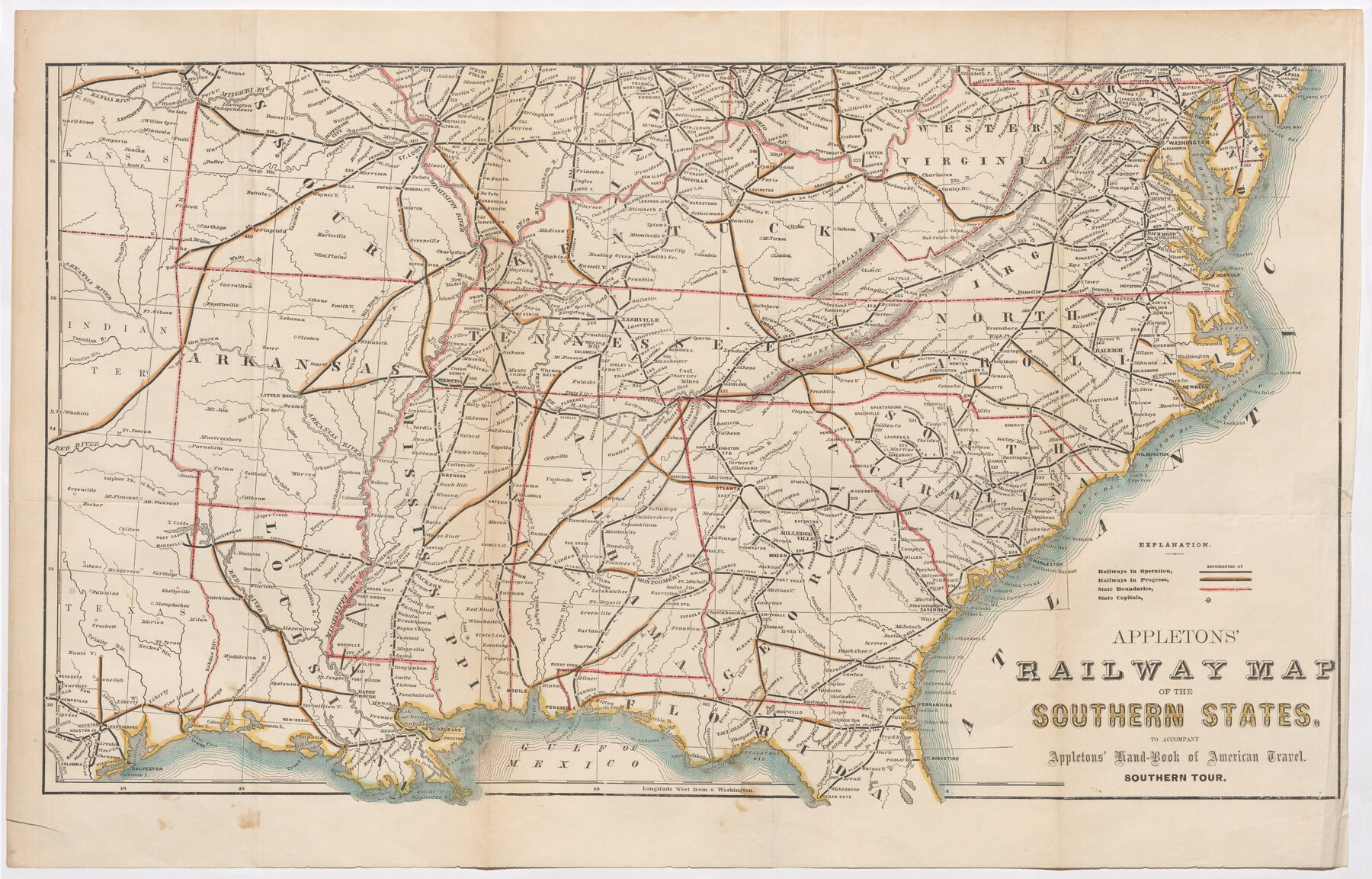
Appletons' Railway Map of the Southern States, to accompany Appletons' Hand-book of American Travel, Southern Tour
-
Map/Doc
95904
-
Collection
Cobb Digital Map Collection
-
Object Dates
1887 (Creation Date)
-
Subjects
Railroads United States
-
Height x Width
15.6 x 24.3 inches
39.6 x 61.7 cm
-
Medium
digital image
-
Comments
Courtesy of John & Diana Cobb.
Part of: Cobb Digital Map Collection
New Birmingham, Cherokee County, Texas

Print $20.00
- Digital $50.00
New Birmingham, Cherokee County, Texas
1891
Size 23.1 x 19.2 inches
Map/Doc 96617

Map of the United States to accompany Granger's Southern and Western Texas Guide

Print $20.00
- Digital $50.00
Map of the United States to accompany Granger's Southern and Western Texas Guide
1878
Size 26.7 x 20.9 inches
Map/Doc 96613
MKT - Missouri, Kansas, Texas Lines

Print $20.00
- Digital $50.00
MKT - Missouri, Kansas, Texas Lines
1930
Size 9.1 x 16.1 inches
Map/Doc 95811
A Geographically Correct County Map of States Traversed by the St. Louis, Iron Mountain & Southern Railway and its Connections

Print $20.00
- Digital $50.00
A Geographically Correct County Map of States Traversed by the St. Louis, Iron Mountain & Southern Railway and its Connections
1876
Size 18.6 x 15.9 inches
Map/Doc 95781
Rand, McNally & Co.'s Texas

Print $20.00
- Digital $50.00
Rand, McNally & Co.'s Texas
1895
Size 21.2 x 28.6 inches
Map/Doc 95885
San Antonio - Places of Interest and how to get there

San Antonio - Places of Interest and how to get there
1920
Map/Doc 96785

San Antonio - as seen by a Northern Visitor

San Antonio - as seen by a Northern Visitor
1927
Size 10.6 x 7.9 inches
Map/Doc 97042
Map of the Texas & Pacific Railway and connections

Print $20.00
- Digital $50.00
Map of the Texas & Pacific Railway and connections
1899
Size 17.8 x 36.3 inches
Map/Doc 95766
Laredo Route. Mexican National Railroad - the Shortest Line to Mexico

Print $20.00
- Digital $50.00
Laredo Route. Mexican National Railroad - the Shortest Line to Mexico
1905
Size 11.0 x 8.5 inches
Map/Doc 96589
Plat showing Gulf Coast Irrigation Company's lands at Raymondville, Lyford and Sebastian, Texas.

Print $20.00
- Digital $50.00
Plat showing Gulf Coast Irrigation Company's lands at Raymondville, Lyford and Sebastian, Texas.
1910
Size 13.9 x 16.9 inches
Map/Doc 95797
You may also like
Lipscomb County

Print $20.00
- Digital $50.00
Lipscomb County
1932
Size 40.2 x 37.1 inches
Map/Doc 77355
Crockett County Sketch File 93

Print $8.00
- Digital $50.00
Crockett County Sketch File 93
1887
Size 12.7 x 8.2 inches
Map/Doc 19946
[Block AX and vicinity]
![90860, [Block AX and vicinity], Twichell Survey Records](https://historictexasmaps.com/wmedia_w700/maps/90860-2.tif.jpg)
Print $20.00
- Digital $50.00
[Block AX and vicinity]
Size 35.9 x 19.7 inches
Map/Doc 90860
Sutton County Working Sketch 14

Print $40.00
- Digital $50.00
Sutton County Working Sketch 14
1972
Size 59.5 x 36.8 inches
Map/Doc 62357
Nolan County Sketch File 1b

Print $20.00
- Digital $50.00
Nolan County Sketch File 1b
1875
Size 37.6 x 46.7 inches
Map/Doc 10555
Parker County Working Sketch 27

Print $20.00
- Digital $50.00
Parker County Working Sketch 27
2009
Map/Doc 89001
Mitchell County Sketch File 12

Print $20.00
- Digital $50.00
Mitchell County Sketch File 12
1912
Size 25.6 x 14.0 inches
Map/Doc 12099
Engineer's Office, Department of the Gulf Map No. 59, Texas prepared by order of Maj. Gen. N. P. Banks under direction of Capt. P. C. Hains, U. S. Engr. & Chief Engr., Dept. of the Gulf

Print $20.00
- Digital $50.00
Engineer's Office, Department of the Gulf Map No. 59, Texas prepared by order of Maj. Gen. N. P. Banks under direction of Capt. P. C. Hains, U. S. Engr. & Chief Engr., Dept. of the Gulf
1865
Size 18.2 x 27.5 inches
Map/Doc 72716
Hood County Sketch File 23a

Print $20.00
- Digital $50.00
Hood County Sketch File 23a
1887
Size 17.2 x 16.5 inches
Map/Doc 11781
[Copy from Harris County map]
![78371, [Copy from Harris County map], General Map Collection](https://historictexasmaps.com/wmedia_w700/maps/78371.tif.jpg)
Print $2.00
- Digital $50.00
[Copy from Harris County map]
Size 7.4 x 3.9 inches
Map/Doc 78371
Ector County Working Sketch Graphic Index - sheet A

Print $20.00
- Digital $50.00
Ector County Working Sketch Graphic Index - sheet A
1943
Size 44.5 x 39.1 inches
Map/Doc 76530
Uvalde County

Print $20.00
- Digital $50.00
Uvalde County
1915
Size 42.9 x 46.2 inches
Map/Doc 63091