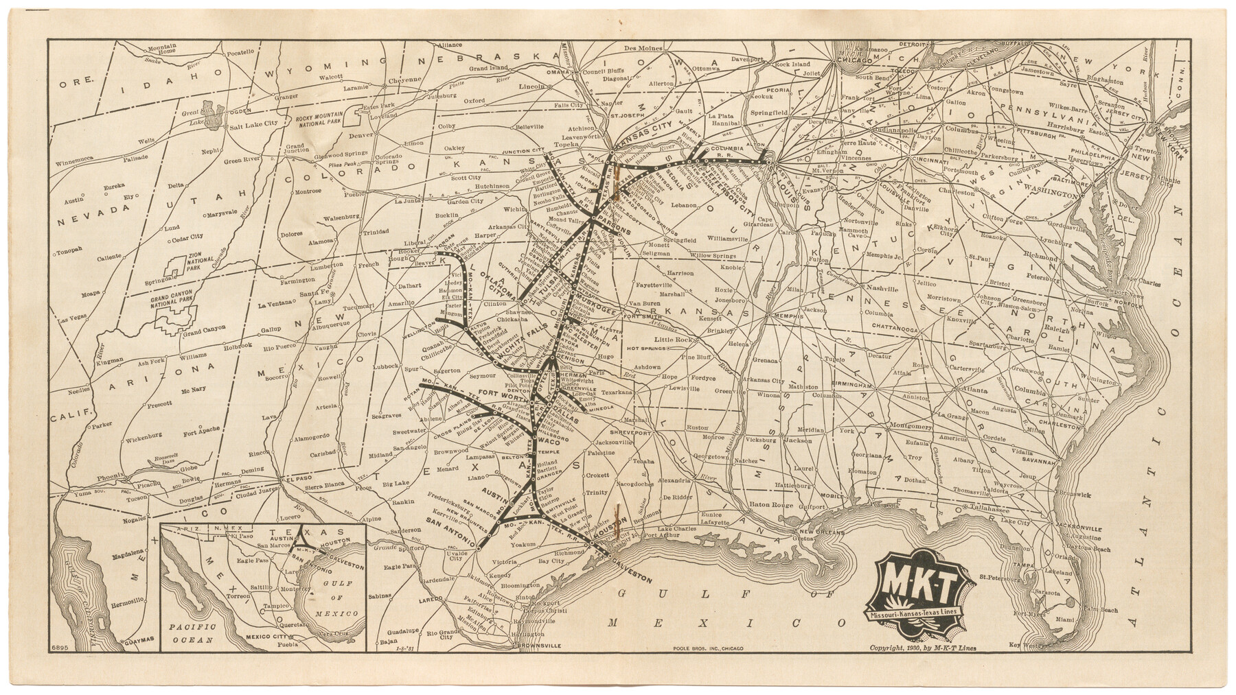
MKT - Missouri, Kansas, Texas Lines
-
Map/Doc
95811
-
Collection
Cobb Digital Map Collection
-
Object Dates
1930 (Creation Date)
-
Subjects
Railroads United States
-
Height x Width
9.1 x 16.1 inches
23.1 x 40.9 cm
-
Medium
digital image
-
Comments
Courtesy of John & Diana Cobb.
To view full booklet in which this map was contained, click "Download PDF" link above.
Related maps
MKT (Missouri Kansas Texas) Katy Railroad Time Tables

Print $54.00
- Digital $50.00
MKT (Missouri Kansas Texas) Katy Railroad Time Tables
1946
Size 9.3 x 16.4 inches
Map/Doc 93981
Part of: Cobb Digital Map Collection
Rand McNally Standard Map of Texas

Print $20.00
- Digital $50.00
Rand McNally Standard Map of Texas
1926
Size 27.3 x 39.9 inches
Map/Doc 95855
A Splendid Endorsement of the Red River Valley Lands in the Famous Red River Valley of North Texas

Print $20.00
- Digital $50.00
A Splendid Endorsement of the Red River Valley Lands in the Famous Red River Valley of North Texas
1901
Size 10.2 x 12.7 inches
Map/Doc 96601


Sectional Map of the Eastern Half of Texas traversed by the Missouri, Kansas & Texas Railway, showing the crops adapted to each section, with the elevation and average annual rainfall

Print $20.00
- Digital $50.00
Sectional Map of the Eastern Half of Texas traversed by the Missouri, Kansas & Texas Railway, showing the crops adapted to each section, with the elevation and average annual rainfall
Size 18.3 x 14.7 inches
Map/Doc 96602
Oklahoma and Indian Territory Along the Frisco

Oklahoma and Indian Territory Along the Frisco
1905
Map/Doc 96771
A Little Journey through the Lower Valley of the Rio Grande - The Magic Valley of Texas

A Little Journey through the Lower Valley of the Rio Grande - The Magic Valley of Texas
1928
Map/Doc 96741
Souvenir of the Picturesque Alamo City - San Antonio, Texas

Souvenir of the Picturesque Alamo City - San Antonio, Texas
1908
Map/Doc 96780
Map of the Texas & Pacific Railway and connections

Print $20.00
- Digital $50.00
Map of the Texas & Pacific Railway and connections
1899
Size 17.8 x 36.3 inches
Map/Doc 95766
A New and Correct County Map of the State of Texas

Print $20.00
- Digital $50.00
A New and Correct County Map of the State of Texas
1891
Size 22.4 x 27.3 inches
Map/Doc 95760

Buffalo Bayou and the Houston Ship Channel 1820-1926

Buffalo Bayou and the Houston Ship Channel 1820-1926
1926
Size 6.2 x 9.1 inches
Map/Doc 97071
You may also like
Navarro County Rolled Sketch 3
Print $20.00
- Digital $50.00
Navarro County Rolled Sketch 3
1893
Size 15.3 x 18.6 inches
Map/Doc 6838
Blanco County Sketch File 48

Print $6.00
- Digital $50.00
Blanco County Sketch File 48
1952
Size 11.7 x 9.0 inches
Map/Doc 14688
Burnet County Working Sketch 20

Print $40.00
- Digital $50.00
Burnet County Working Sketch 20
1983
Size 48.1 x 41.2 inches
Map/Doc 67863
Pecos County Working Sketch 125

Print $40.00
- Digital $50.00
Pecos County Working Sketch 125
1974
Size 53.4 x 37.0 inches
Map/Doc 71598
Loving County Working Sketch 8

Print $40.00
- Digital $50.00
Loving County Working Sketch 8
1952
Size 21.9 x 56.6 inches
Map/Doc 70640
Hudspeth County Working Sketch 11

Print $20.00
- Digital $50.00
Hudspeth County Working Sketch 11
1946
Size 32.1 x 36.2 inches
Map/Doc 66292
Map of Comanche County

Print $40.00
- Digital $50.00
Map of Comanche County
1895
Size 47.5 x 50.0 inches
Map/Doc 4735
Cameron County Rolled Sketch 25

Print $20.00
- Digital $50.00
Cameron County Rolled Sketch 25
1977
Size 24.8 x 36.5 inches
Map/Doc 5797
Map of Sherman County

Print $20.00
- Digital $50.00
Map of Sherman County
1902
Size 40.9 x 36.6 inches
Map/Doc 16815
Blanco County Sketch File 43

Print $6.00
- Digital $50.00
Blanco County Sketch File 43
1901
Size 9.7 x 6.2 inches
Map/Doc 14666
Mitchell County Working Sketch 8

Print $20.00
- Digital $50.00
Mitchell County Working Sketch 8
1975
Size 31.9 x 26.3 inches
Map/Doc 71065
Coke County Working Sketch 25
Print $20.00
- Digital $50.00
Coke County Working Sketch 25
1961
Size 31.4 x 40.7 inches
Map/Doc 68062