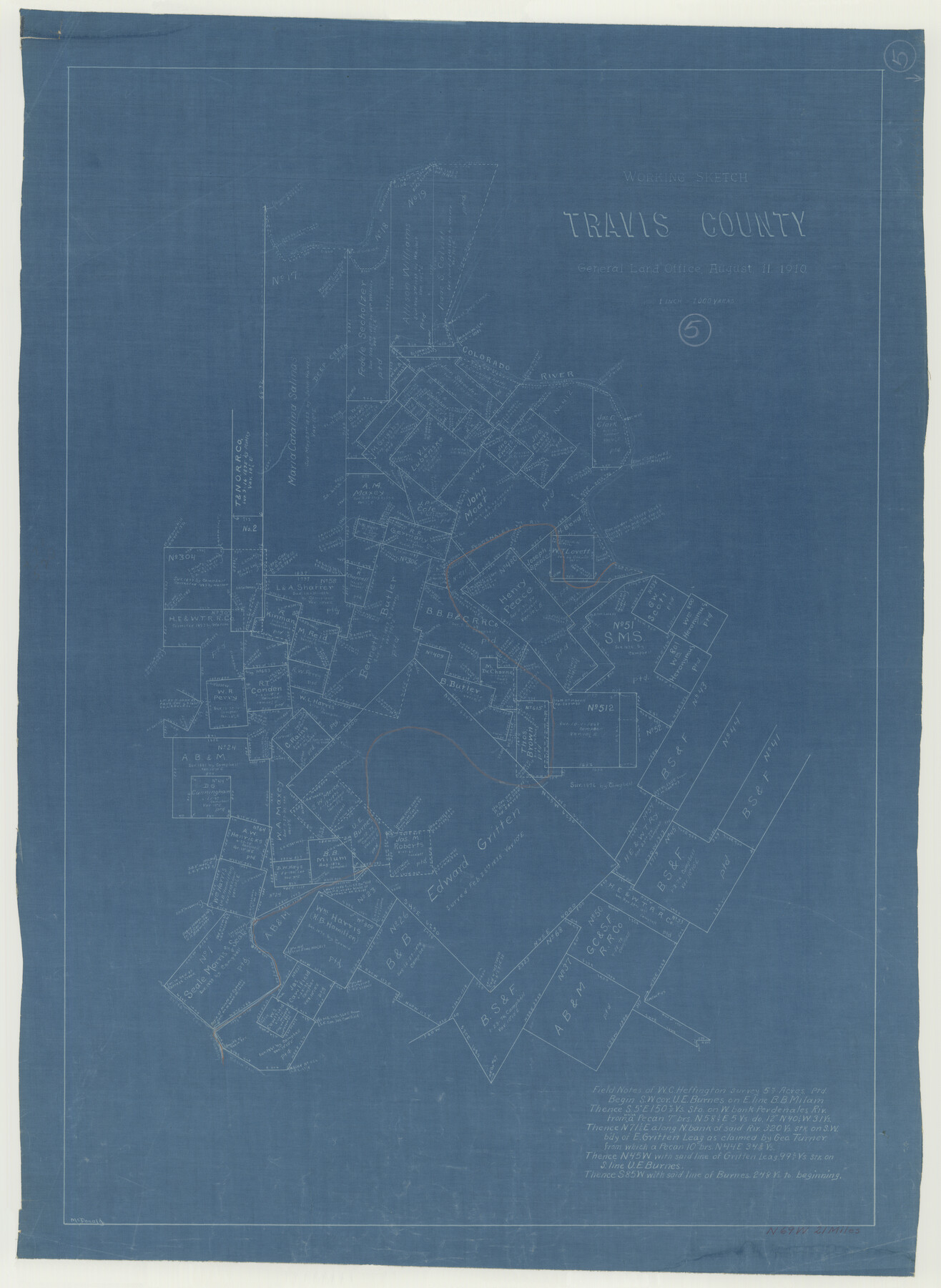
Travis County Working Sketch 5
-
Map/Doc
69389
-
Collection
General Map Collection
-
Object Dates
8/11/1910 (Creation Date)
-
Counties
Travis
-
Subjects
Surveying Working Sketch
-
Height x Width
28.3 x 20.7 inches
71.9 x 52.6 cm
-
Scale
1" = 1000 varas
Part of: General Map Collection
Webb County Rolled Sketch 45

Print $20.00
- Digital $50.00
Webb County Rolled Sketch 45
1942
Size 17.4 x 22.2 inches
Map/Doc 8200
Map of Bell County

Print $40.00
- Digital $50.00
Map of Bell County
1896
Size 49.0 x 53.5 inches
Map/Doc 4768
Flight Mission No. DCL-6C, Frame 21, Kenedy County

Print $20.00
- Digital $50.00
Flight Mission No. DCL-6C, Frame 21, Kenedy County
1943
Size 18.7 x 22.5 inches
Map/Doc 85878
Crockett County Working Sketch 49

Print $20.00
- Digital $50.00
Crockett County Working Sketch 49
1938
Size 46.7 x 43.9 inches
Map/Doc 68382
Comanche County Working Sketch 9

Print $20.00
- Digital $50.00
Comanche County Working Sketch 9
1954
Size 18.6 x 21.5 inches
Map/Doc 68143
Pecos County Sketch File 85

Print $19.00
- Digital $50.00
Pecos County Sketch File 85
1948
Size 14.6 x 9.2 inches
Map/Doc 33955
San Patricio County Rolled Sketch 46

Print $20.00
- Digital $50.00
San Patricio County Rolled Sketch 46
1983
Size 19.6 x 25.5 inches
Map/Doc 7730
Comanche County Boundary File 1

Print $20.00
- Digital $50.00
Comanche County Boundary File 1
Size 14.4 x 8.8 inches
Map/Doc 51778
Fort Bend County Sketch File 21

Print $4.00
- Digital $50.00
Fort Bend County Sketch File 21
1882
Size 8.8 x 13.4 inches
Map/Doc 22954
Current Miscellaneous File 101

Print $46.00
- Digital $50.00
Current Miscellaneous File 101
1931
Size 8.8 x 14.2 inches
Map/Doc 74357
Galveston County Sketch File 70

Print $26.00
- Digital $50.00
Galveston County Sketch File 70
1983
Size 11.3 x 8.7 inches
Map/Doc 23928
Newton County Rolled Sketch 19

Print $20.00
- Digital $50.00
Newton County Rolled Sketch 19
1956
Size 42.1 x 33.5 inches
Map/Doc 6848
You may also like
Mineral Locality Map of Texas Showing Occurances of Useful Minerals, Rocks, Oil and Gas, and Other Geologic Substances

Print $40.00
- Digital $50.00
Mineral Locality Map of Texas Showing Occurances of Useful Minerals, Rocks, Oil and Gas, and Other Geologic Substances
1945
Size 43.8 x 53.0 inches
Map/Doc 94140
Flight Mission No. DQN-2K, Frame 73, Calhoun County

Print $20.00
- Digital $50.00
Flight Mission No. DQN-2K, Frame 73, Calhoun County
1953
Size 18.5 x 22.2 inches
Map/Doc 84265
Presidio County Rolled Sketch 47

Print $20.00
- Digital $50.00
Presidio County Rolled Sketch 47
1908
Size 30.8 x 32.2 inches
Map/Doc 7343
Brazos County Working Sketch 2

Print $20.00
- Digital $50.00
Brazos County Working Sketch 2
1950
Size 31.9 x 36.0 inches
Map/Doc 67477
Wise County Sketch File 51

Print $2.00
- Digital $50.00
Wise County Sketch File 51
Size 8.5 x 3.9 inches
Map/Doc 40618
Sketch in Gaines and Dawson Counties

Print $20.00
- Digital $50.00
Sketch in Gaines and Dawson Counties
1950
Size 16.0 x 31.3 inches
Map/Doc 92586
Aransas County Aerial Photograph Index Sheet 1

Print $20.00
- Digital $50.00
Aransas County Aerial Photograph Index Sheet 1
1957
Size 22.9 x 18.2 inches
Map/Doc 83659
Mitchell County

Print $20.00
- Digital $50.00
Mitchell County
1922
Size 42.6 x 38.3 inches
Map/Doc 2309
Wichita County

Print $20.00
- Digital $50.00
Wichita County
1971
Size 39.1 x 40.8 inches
Map/Doc 95673
Starr County Working Sketch 29

Print $20.00
- Digital $50.00
Starr County Working Sketch 29
2007
Size 28.6 x 34.0 inches
Map/Doc 87208
Map of Donley County

Print $20.00
- Digital $50.00
Map of Donley County
1894
Size 44.6 x 35.8 inches
Map/Doc 16823
Franklin County Sketch File 4

Print $6.00
- Digital $50.00
Franklin County Sketch File 4
1855
Size 13.4 x 11.4 inches
Map/Doc 23015