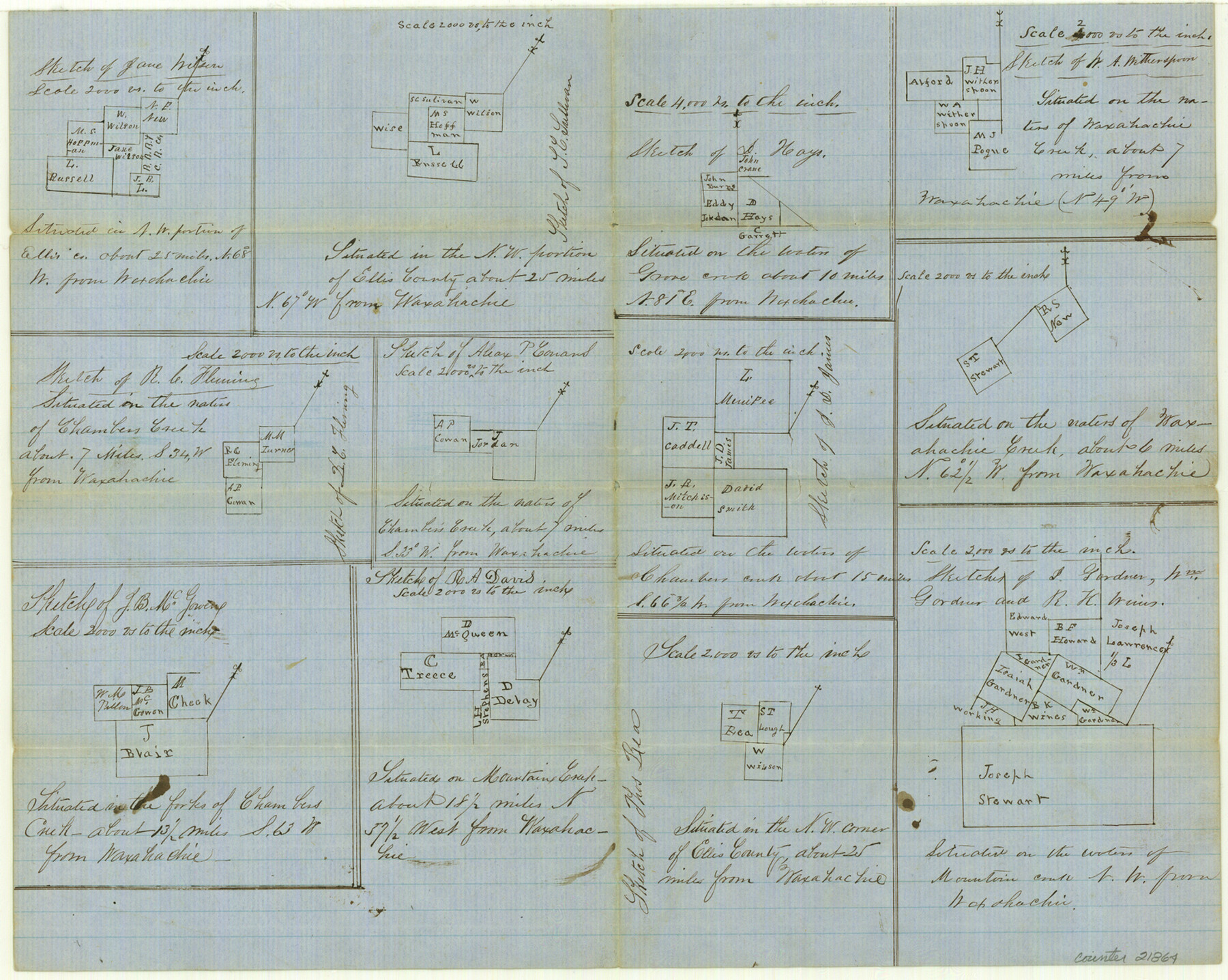
Ellis County Sketch File 18a
[Multiple sketches]
- 
                          Map/Doc
21864
 - 
                            Collection
General Map Collection
 - 
                            Object Dates
1861/9/28 (File Date)
 - 
                            Counties
Ellis
 - 
                            Subjects
Surveying Sketch File
 - 
                            Height x Width
12.8 x 16.0 inches
32.5 x 40.6 cm
 - 
                            Medium
paper, manuscript
 - 
                            Scale
1:2000; 1:4000
 - 
                            Features
Waxahachie
Grove Creek
Waxahachie Creek
Chambers Creek
Mountain Creek
 
Part of: General Map Collection
            Burnet County Working Sketch 3


                                            Print $20.00                    
                                             -                         Digital $50.00                                    
                Burnet County Working Sketch 3
1953
Size 31.4 x 26.9 inches
                                Map/Doc 67846
            
            McCulloch County Rolled Sketch 9


                                            Print $20.00                    
                                             -                         Digital $50.00                                    
                McCulloch County Rolled Sketch 9
Size 21.0 x 25.9 inches
                                Map/Doc 6719
            
            Collin County Working Sketch 1


                                            Print $20.00                    
                                             -                         Digital $50.00                                    
                Collin County Working Sketch 1
1921
Size 26.6 x 23.4 inches
                                Map/Doc 68095
            
            Blanco County Rolled Sketch 21


                                            Print $20.00                    
                                             -                         Digital $50.00                                    
                Blanco County Rolled Sketch 21
2007
Size 18.1 x 13.0 inches
                                Map/Doc 87925
            
            New Map of that portion of North America, exhibiting the United States and Territories, the Canadas, New Brunswick, Nova Scotia and Mexico, also Central America and the West India Islands compiled from the most recent surveys and authentic sources


                                            Print $40.00                    
                                             -                         Digital $50.00                                    
                New Map of that portion of North America, exhibiting the United States and Territories, the Canadas, New Brunswick, Nova Scotia and Mexico, also Central America and the West India Islands compiled from the most recent surveys and authentic sources
1854
Size 59.4 x 63.0 inches
                                Map/Doc 93968
            
            Surveys East of Cedar Lake


                                            Print $20.00                    
                                             -                         Digital $50.00                                    
                Surveys East of Cedar Lake
1824
Size 13.3 x 20.9 inches
                                Map/Doc 210
            
            Polk County Sketch File 12


                                            Print $4.00                    
                                             -                         Digital $50.00                                    
                Polk County Sketch File 12
Size 9.0 x 5.8 inches
                                Map/Doc 34146
            
            San Patricio County NRC Article 33.136 Sketch 4A


                                            Print $3.00                    
                                             -                         Digital $50.00                                    
                San Patricio County NRC Article 33.136 Sketch 4A
Size 17.0 x 11.0 inches
                                Map/Doc 94696
            
            Presidio County Working Sketch 69


                                            Print $20.00                    
                                             -                         Digital $50.00                                    
                Presidio County Working Sketch 69
1960
Size 33.3 x 41.3 inches
                                Map/Doc 71746
            You may also like
            University Land Field Notes for Blocks 39, 41, 42, 44, 45, 46, 47, 50, and 51 in Crockett County, Blocks 38 and 40 in Crockett and Irion Counties, and Blocks 48 and 49 in Crockett and Reagan Counties, and Block 43 in Crockett, Irion, and Reagan Counties


            University Land Field Notes for Blocks 39, 41, 42, 44, 45, 46, 47, 50, and 51 in Crockett County, Blocks 38 and 40 in Crockett and Irion Counties, and Blocks 48 and 49 in Crockett and Reagan Counties, and Block 43 in Crockett, Irion, and Reagan Counties
Map/Doc 81718
            
            Map of Glasscock County


                                            Print $20.00                    
                                             -                         Digital $50.00                                    
                Map of Glasscock County
Size 18.9 x 23.2 inches
                                Map/Doc 90711
            
            Brazoria County Working Sketch 8


                                            Print $20.00                    
                                             -                         Digital $50.00                                    
                Brazoria County Working Sketch 8
1932
Size 25.9 x 21.5 inches
                                Map/Doc 67493
            
            Hutchinson County Working Sketch 25


                                            Print $20.00                    
                                             -                         Digital $50.00                                    
                Hutchinson County Working Sketch 25
1972
Size 21.5 x 25.0 inches
                                Map/Doc 66385
            
            San Augustine County


                                            Print $20.00                    
                                             -                         Digital $50.00                                    
                San Augustine County
1895
Size 23.7 x 17.2 inches
                                Map/Doc 4015
            
            Zapata County Working Sketch 15


                                            Print $20.00                    
                                             -                         Digital $50.00                                    
                Zapata County Working Sketch 15
1969
Size 38.2 x 38.7 inches
                                Map/Doc 62066
            
            Matagorda County Sketch File 10


                                            Print $26.00                    
                                             -                         Digital $50.00                                    
                Matagorda County Sketch File 10
Size 8.3 x 5.2 inches
                                Map/Doc 30755
            
            Current Miscellaneous File 109


                                            Print $9.00                    
                                             -                         Digital $50.00                                    
                Current Miscellaneous File 109
1967
Size 9.7 x 10.3 inches
                                Map/Doc 74710
            
            Flight Mission No. DCL-6C, Frame 26, Kenedy County


                                            Print $20.00                    
                                             -                         Digital $50.00                                    
                Flight Mission No. DCL-6C, Frame 26, Kenedy County
1943
Size 18.7 x 22.5 inches
                                Map/Doc 85883
            
            La Salle County Boundary File 1


                                            Print $24.00                    
                                             -                         Digital $50.00                                    
                La Salle County Boundary File 1
Size 8.7 x 14.2 inches
                                Map/Doc 56239
            
            The Land Offices. No. 11, Victoria, December 22, 1836


                                            Print $20.00                    
                                    
                The Land Offices. No. 11, Victoria, December 22, 1836
2020
Size 21.8 x 21.7 inches
                                Map/Doc 96424
            
            General Highway Map, Stonewall County, Texas


                                            Print $20.00                    
                                    
                General Highway Map, Stonewall County, Texas
1961
Size 18.3 x 25.1 inches
                                Map/Doc 79662