Old Miscellaneous File 30
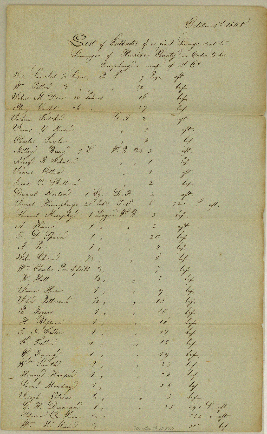
List of field notes of original surveys sent to Surveyor of Harrison County and list of field notes in Austin's Colony sent to surveyor of Jackson County
-
Map/Doc
75740
-
Collection
General Map Collection
-
Object Dates
1845/10/1 (Creation Date)
1985/2/8 (File Date)
-
Height x Width
13.3 x 8.2 inches
33.8 x 20.8 cm
Part of: General Map Collection
Polk County Sketch File 12

Print $4.00
- Digital $50.00
Polk County Sketch File 12
Size 9.0 x 5.8 inches
Map/Doc 34146
DeWitt County Working Sketch 13

Print $20.00
- Digital $50.00
DeWitt County Working Sketch 13
1986
Size 37.6 x 40.9 inches
Map/Doc 68603
Kent County Boundary File 10

Print $16.00
- Digital $50.00
Kent County Boundary File 10
Size 14.0 x 8.8 inches
Map/Doc 55887
Louisiana and Texas Intracoastal Waterway - High Island to Port Bolivar Dredging - Sheet 5

Print $20.00
- Digital $50.00
Louisiana and Texas Intracoastal Waterway - High Island to Port Bolivar Dredging - Sheet 5
1943
Size 31.4 x 41.8 inches
Map/Doc 61824
[Surveys along the Frio River]
![129, [Surveys along the Frio River], General Map Collection](https://historictexasmaps.com/wmedia_w700/maps/129.tif.jpg)
Print $20.00
- Digital $50.00
[Surveys along the Frio River]
1841
Size 12.0 x 16.6 inches
Map/Doc 129
Tarrant County State Real Property Sketch 1

Print $60.00
- Digital $50.00
Tarrant County State Real Property Sketch 1
2007
Size 24.5 x 35.3 inches
Map/Doc 88666
Copy of Surveyor's Field Book, Morris Browning - In Blocks 7, 5 & 4, I&GNRRCo., Hutchinson and Carson Counties, Texas

Print $2.00
- Digital $50.00
Copy of Surveyor's Field Book, Morris Browning - In Blocks 7, 5 & 4, I&GNRRCo., Hutchinson and Carson Counties, Texas
1888
Size 7.0 x 8.8 inches
Map/Doc 62272
Montgomery County Working Sketch Graphic Index, Sheet 1 (Sketches 1 to 35)

Print $40.00
- Digital $50.00
Montgomery County Working Sketch Graphic Index, Sheet 1 (Sketches 1 to 35)
1943
Size 43.0 x 51.9 inches
Map/Doc 76646
Map of part of Matagorda Island

Print $20.00
- Digital $50.00
Map of part of Matagorda Island
1859
Size 30.2 x 32.0 inches
Map/Doc 69982
Shelby County Sketch File 24

Print $36.00
- Digital $50.00
Shelby County Sketch File 24
1850
Size 13.0 x 8.1 inches
Map/Doc 36647
Knox County Rolled Sketch 10A

Print $20.00
- Digital $50.00
Knox County Rolled Sketch 10A
Size 40.8 x 36.8 inches
Map/Doc 61734
Orange County NRC Article 33.136 Sketch 5

Print $62.00
- Digital $50.00
Orange County NRC Article 33.136 Sketch 5
2014
Size 26.1 x 22.7 inches
Map/Doc 94946
You may also like
Reagan County Rolled Sketch 18

Print $20.00
- Digital $50.00
Reagan County Rolled Sketch 18
Size 32.1 x 22.9 inches
Map/Doc 7444
Jasper County Sketch File 6

Print $26.00
- Digital $50.00
Jasper County Sketch File 6
1867
Size 12.8 x 8.2 inches
Map/Doc 27771
Callahan County Rolled Sketch 1

Print $20.00
- Digital $50.00
Callahan County Rolled Sketch 1
1944
Size 26.9 x 26.3 inches
Map/Doc 5379

Hartley County Rolled Sketch 9

Print $20.00
- Digital $50.00
Hartley County Rolled Sketch 9
2001
Size 22.7 x 34.7 inches
Map/Doc 76407
Trinity County Rolled Sketch 3

Print $40.00
- Digital $50.00
Trinity County Rolled Sketch 3
1948
Size 33.8 x 50.3 inches
Map/Doc 10025
Sutton County Rolled Sketch H

Print $40.00
- Digital $50.00
Sutton County Rolled Sketch H
Size 24.9 x 50.0 inches
Map/Doc 9973
General Highway Map, Lipscomb County, Texas

Print $20.00
General Highway Map, Lipscomb County, Texas
1961
Size 18.1 x 24.6 inches
Map/Doc 79573
Brewster County Working Sketch 71a

Print $40.00
- Digital $50.00
Brewster County Working Sketch 71a
1962
Size 43.5 x 56.0 inches
Map/Doc 67869
Montgomery County

Print $20.00
- Digital $50.00
Montgomery County
1861
Size 18.4 x 22.3 inches
Map/Doc 3890
Ochiltree County Working Sketch 3

Print $40.00
- Digital $50.00
Ochiltree County Working Sketch 3
1961
Size 111.8 x 37.5 inches
Map/Doc 71316
Bosque County Sketch File 28

Print $6.00
- Digital $50.00
Bosque County Sketch File 28
1888
Size 7.3 x 10.3 inches
Map/Doc 14813