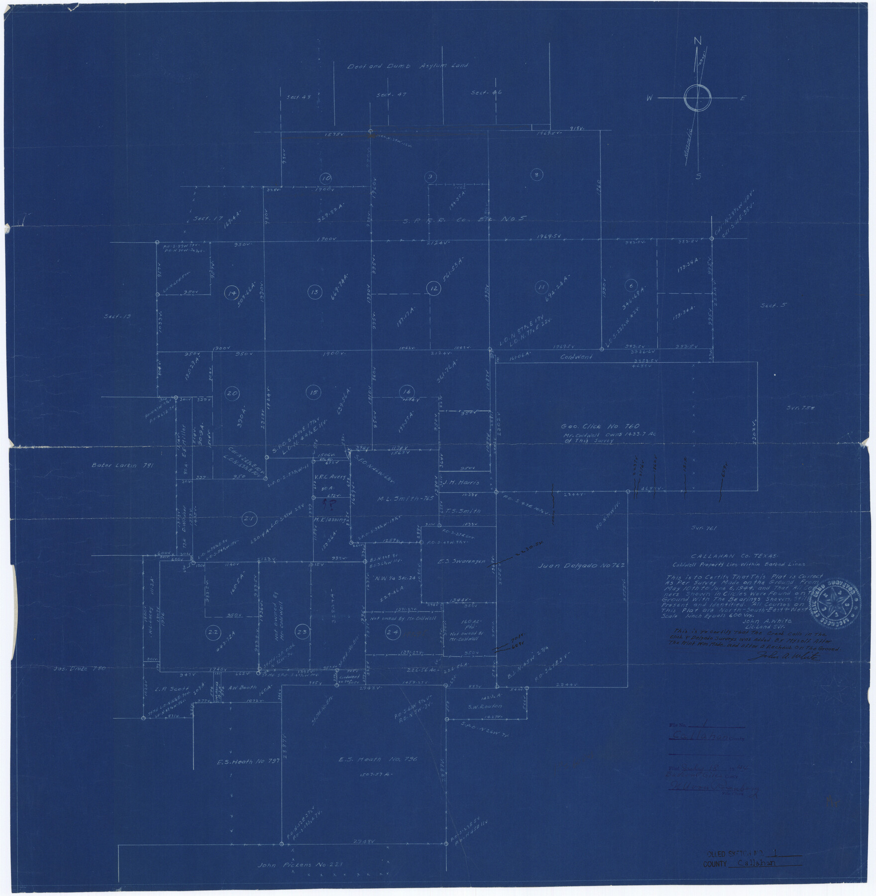
Callahan County Rolled Sketch 1
[S. P. R.R. Co. Block 5 and adjoining surveys south and east]
-
Map/Doc
5379
-
Collection
General Map Collection
-
Object Dates
1944/6/6 (Creation Date)
1944/7/18 (File Date)
-
People and Organizations
John A. White (Surveyor/Engineer)
-
Counties
Callahan
-
Subjects
Surveying Rolled Sketch
-
Height x Width
26.9 x 26.3 inches
68.3 x 66.8 cm
-
Medium
blueprint/diazo
-
Scale
1" = 600 varas
-
Comments
See Callahan County Sketch File 15 (35890) for surveyor’s report.
Related maps
Callahan County Sketch File 15

Print $16.00
- Digital $50.00
Callahan County Sketch File 15
1944
Size 11.2 x 8.8 inches
Map/Doc 35890
Part of: General Map Collection
Flight Mission No. BQR-3K, Frame 85, Brazoria County

Print $20.00
- Digital $50.00
Flight Mission No. BQR-3K, Frame 85, Brazoria County
1952
Size 18.9 x 22.4 inches
Map/Doc 83977
Flight Mission No. CUG-1P, Frame 21, Kleberg County

Print $20.00
- Digital $50.00
Flight Mission No. CUG-1P, Frame 21, Kleberg County
1956
Size 18.5 x 22.2 inches
Map/Doc 86111
Austin County Rolled Sketch 5A

Print $40.00
- Digital $50.00
Austin County Rolled Sketch 5A
Size 54.2 x 44.1 inches
Map/Doc 8437
DeWitt County Working Sketch 10

Print $20.00
- Digital $50.00
DeWitt County Working Sketch 10
1980
Size 15.1 x 12.0 inches
Map/Doc 68600
Gillespie County Rolled Sketch O

Print $20.00
- Digital $50.00
Gillespie County Rolled Sketch O
1846
Size 42.6 x 20.0 inches
Map/Doc 6007
Ward County Sketch File 10

Print $6.00
- Digital $50.00
Ward County Sketch File 10
1936
Size 11.2 x 8.9 inches
Map/Doc 39635
Flight Mission No. DIX-10P, Frame 81, Aransas County

Print $20.00
- Digital $50.00
Flight Mission No. DIX-10P, Frame 81, Aransas County
1956
Size 18.7 x 22.4 inches
Map/Doc 83942
Cass County Working Sketch 19

Print $20.00
- Digital $50.00
Cass County Working Sketch 19
1959
Size 27.2 x 29.3 inches
Map/Doc 67922
Calhoun County Rolled Sketch 26

Print $40.00
- Digital $50.00
Calhoun County Rolled Sketch 26
1941
Size 25.5 x 112.1 inches
Map/Doc 8556
Washington County Sketch File 7

Print $4.00
- Digital $50.00
Washington County Sketch File 7
1873
Size 12.2 x 7.6 inches
Map/Doc 39654
Nueces County Rolled Sketch 92

Print $222.00
Nueces County Rolled Sketch 92
1983
Size 24.6 x 43.7 inches
Map/Doc 7028
Atascosa County Rolled Sketch 24

Print $20.00
- Digital $50.00
Atascosa County Rolled Sketch 24
Size 38.3 x 45.2 inches
Map/Doc 5101
You may also like
Waller County Sketch File 7

Print $4.00
- Digital $50.00
Waller County Sketch File 7
1873
Size 9.4 x 8.2 inches
Map/Doc 39608
Navigation Maps of Gulf Intracoastal Waterway, Port Arthur to Brownsville, Texas

Print $4.00
- Digital $50.00
Navigation Maps of Gulf Intracoastal Waterway, Port Arthur to Brownsville, Texas
1951
Size 16.7 x 21.4 inches
Map/Doc 65446
Angelina County Sketch File 18

Print $4.00
- Digital $50.00
Angelina County Sketch File 18
Size 8.6 x 3.9 inches
Map/Doc 13028
Val Verde County Working Sketch 121

Print $40.00
- Digital $50.00
Val Verde County Working Sketch 121
2005
Size 34.0 x 54.2 inches
Map/Doc 83590
General Highway Map, Hemphill County, Texas

Print $20.00
General Highway Map, Hemphill County, Texas
1940
Size 18.2 x 24.8 inches
Map/Doc 79124
Lavaca County Working Sketch 6

Print $20.00
- Digital $50.00
Lavaca County Working Sketch 6
1941
Size 20.8 x 22.0 inches
Map/Doc 70359
Brazoria County Sketch File 59

Print $364.00
- Digital $50.00
Brazoria County Sketch File 59
1996
Size 14.9 x 8.3 inches
Map/Doc 15398
Flight Mission No. CGI-1N, Frame 137, Cameron County

Print $20.00
- Digital $50.00
Flight Mission No. CGI-1N, Frame 137, Cameron County
1955
Size 15.5 x 18.8 inches
Map/Doc 84493
Victoria County Rolled Sketch 4B

Print $40.00
- Digital $50.00
Victoria County Rolled Sketch 4B
1963
Size 65.3 x 43.3 inches
Map/Doc 10096
[Bastrop District]
![3131, [Bastrop District], General Map Collection](https://historictexasmaps.com/wmedia_w700/maps/3131.tif.jpg)
Print $40.00
- Digital $50.00
[Bastrop District]
1895
Size 36.5 x 52.0 inches
Map/Doc 3131
Walker County Sketch File 6

Print $4.00
- Digital $50.00
Walker County Sketch File 6
1876
Size 8.1 x 6.1 inches
Map/Doc 39557
Culberson County Working Sketch 25

Print $40.00
- Digital $50.00
Culberson County Working Sketch 25
1951
Size 30.5 x 52.9 inches
Map/Doc 68478