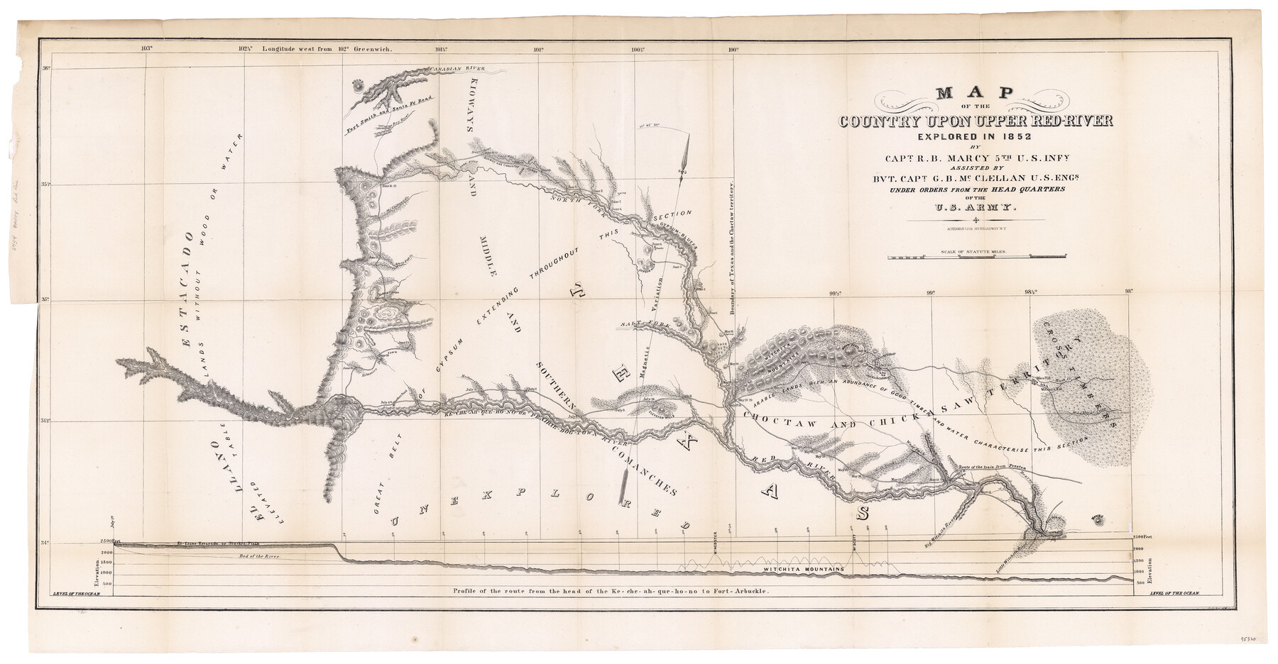
Map of the Country upon Upper Red-River explored in 1852 by Capt. R.B. Marcy 5th U.S. Infy. assisted by Bvt. Capt. G.B. McClellan U.S. Engs. under orders from the Head Quarters of the U.S. Army
-
Map/Doc
95320
-
Collection
General Map Collection
-
Object Dates
1852 (Survey Date)
1854 (Publication Date)
-
People and Organizations
War Department (Publisher)
Ackerman Lith. (Printer)
Randolph B. Marcy (Explorer)
George B. McClellan (Explorer)
-
Subjects
Military
-
Height x Width
18.7 x 36.0 inches
47.5 x 91.4 cm
-
Medium
paper, etching/engraving/lithograph
-
Comments
Map removed from "Exploration of the Red River of Louisiana in the year 1852" (GLO Document 95321).
Related maps
Exploration of the Red River of Louisiana in the the year 1852 by Randolph B. Marcy, Captain Fifth Infantry U.S. Army; assisted by George B. McClellan, Brevet Captain U.S. Engineers

Exploration of the Red River of Louisiana in the the year 1852 by Randolph B. Marcy, Captain Fifth Infantry U.S. Army; assisted by George B. McClellan, Brevet Captain U.S. Engineers
Size 9.5 x 11.7 inches
Map/Doc 95321
Part of: General Map Collection
Smith County Working Sketch 11

Print $20.00
- Digital $50.00
Smith County Working Sketch 11
1960
Size 18.6 x 21.6 inches
Map/Doc 63896
Loving County Boundary File 1

Print $6.00
- Digital $50.00
Loving County Boundary File 1
Size 11.2 x 8.7 inches
Map/Doc 56452
Flight Mission No. DAG-24K, Frame 130, Matagorda County

Print $20.00
- Digital $50.00
Flight Mission No. DAG-24K, Frame 130, Matagorda County
1953
Size 17.1 x 18.8 inches
Map/Doc 86548
Galveston County Rolled Sketch JR

Print $20.00
- Digital $50.00
Galveston County Rolled Sketch JR
1938
Size 37.5 x 36.7 inches
Map/Doc 9086
Angelina County Working Sketch 22a

Print $20.00
- Digital $50.00
Angelina County Working Sketch 22a
1953
Size 22.3 x 20.1 inches
Map/Doc 67103
Matagorda County Working Sketch 17

Print $20.00
- Digital $50.00
Matagorda County Working Sketch 17
1961
Size 31.2 x 42.2 inches
Map/Doc 70875
Sherman County Rolled Sketch 9

Print $20.00
- Digital $50.00
Sherman County Rolled Sketch 9
1942
Size 33.5 x 26.7 inches
Map/Doc 7789
Bien & Sterner's New Rail Road Map of the United States and the Canadas compiled from the latest surveys & locations under the direction of Zerah Colburn Esq., editor of the Rail Road Advocate

Print $20.00
- Digital $50.00
Bien & Sterner's New Rail Road Map of the United States and the Canadas compiled from the latest surveys & locations under the direction of Zerah Colburn Esq., editor of the Rail Road Advocate
1855
Size 27.5 x 32.3 inches
Map/Doc 95963
Topographical Map of the Rio Grande, Sheet No. 7

Print $20.00
- Digital $50.00
Topographical Map of the Rio Grande, Sheet No. 7
1912
Map/Doc 89531
Travis County State Real Property Sketch 4

Print $20.00
- Digital $50.00
Travis County State Real Property Sketch 4
1987
Size 25.7 x 30.7 inches
Map/Doc 61695
Upton County Sketch File 6

Print $10.00
- Digital $50.00
Upton County Sketch File 6
1909
Size 11.3 x 8.6 inches
Map/Doc 38815
Flight Mission No. DCL-4C, Frame 66, Kenedy County

Print $20.00
- Digital $50.00
Flight Mission No. DCL-4C, Frame 66, Kenedy County
1943
Size 18.6 x 22.3 inches
Map/Doc 85811
You may also like
Culberson County Sketch File 30

Print $22.00
- Digital $50.00
Culberson County Sketch File 30
1950
Size 14.2 x 8.7 inches
Map/Doc 20282
[State Line - 103rd Meridian - in relation to Leagues]
![91551, [State Line - 103rd Meridian - in relation to Leagues], Twichell Survey Records](https://historictexasmaps.com/wmedia_w700/maps/91551-2.tif.jpg)
Print $20.00
- Digital $50.00
[State Line - 103rd Meridian - in relation to Leagues]
Size 19.9 x 8.3 inches
Map/Doc 91551
Burnet County Rolled Sketch 8

Print $40.00
- Digital $50.00
Burnet County Rolled Sketch 8
1971
Size 36.9 x 49.9 inches
Map/Doc 8554
Outer Continental Shelf Leasing Maps (Texas Offshore Operations)

Print $20.00
- Digital $50.00
Outer Continental Shelf Leasing Maps (Texas Offshore Operations)
Size 21.0 x 15.2 inches
Map/Doc 75840
Orange County Working Sketch 54a

Print $40.00
- Digital $50.00
Orange County Working Sketch 54a
2008
Size 22.9 x 48.0 inches
Map/Doc 88742
El Paso County Sketch File 35 (6)

Print $20.00
- Digital $50.00
El Paso County Sketch File 35 (6)
1886
Size 20.3 x 36.9 inches
Map/Doc 11460
McLennan County Sketch File 20

Print $2.00
- Digital $50.00
McLennan County Sketch File 20
Size 8.0 x 9.1 inches
Map/Doc 31293
Presidio County Rolled Sketch 30

Print $40.00
- Digital $50.00
Presidio County Rolled Sketch 30
Size 40.8 x 84.9 inches
Map/Doc 9767
Lynn County Rolled Sketch 3

Print $20.00
- Digital $50.00
Lynn County Rolled Sketch 3
Size 27.3 x 29.9 inches
Map/Doc 6644
Val Verde County Working Sketch 100

Print $20.00
- Digital $50.00
Val Verde County Working Sketch 100
1981
Size 22.3 x 32.0 inches
Map/Doc 72235
Chambers County Rolled Sketch 8

Print $20.00
- Digital $50.00
Chambers County Rolled Sketch 8
Size 39.8 x 30.5 inches
Map/Doc 8612
Cochran County Rolled Sketch 5

Print $20.00
- Digital $50.00
Cochran County Rolled Sketch 5
1949
Size 21.5 x 22.0 inches
Map/Doc 5502