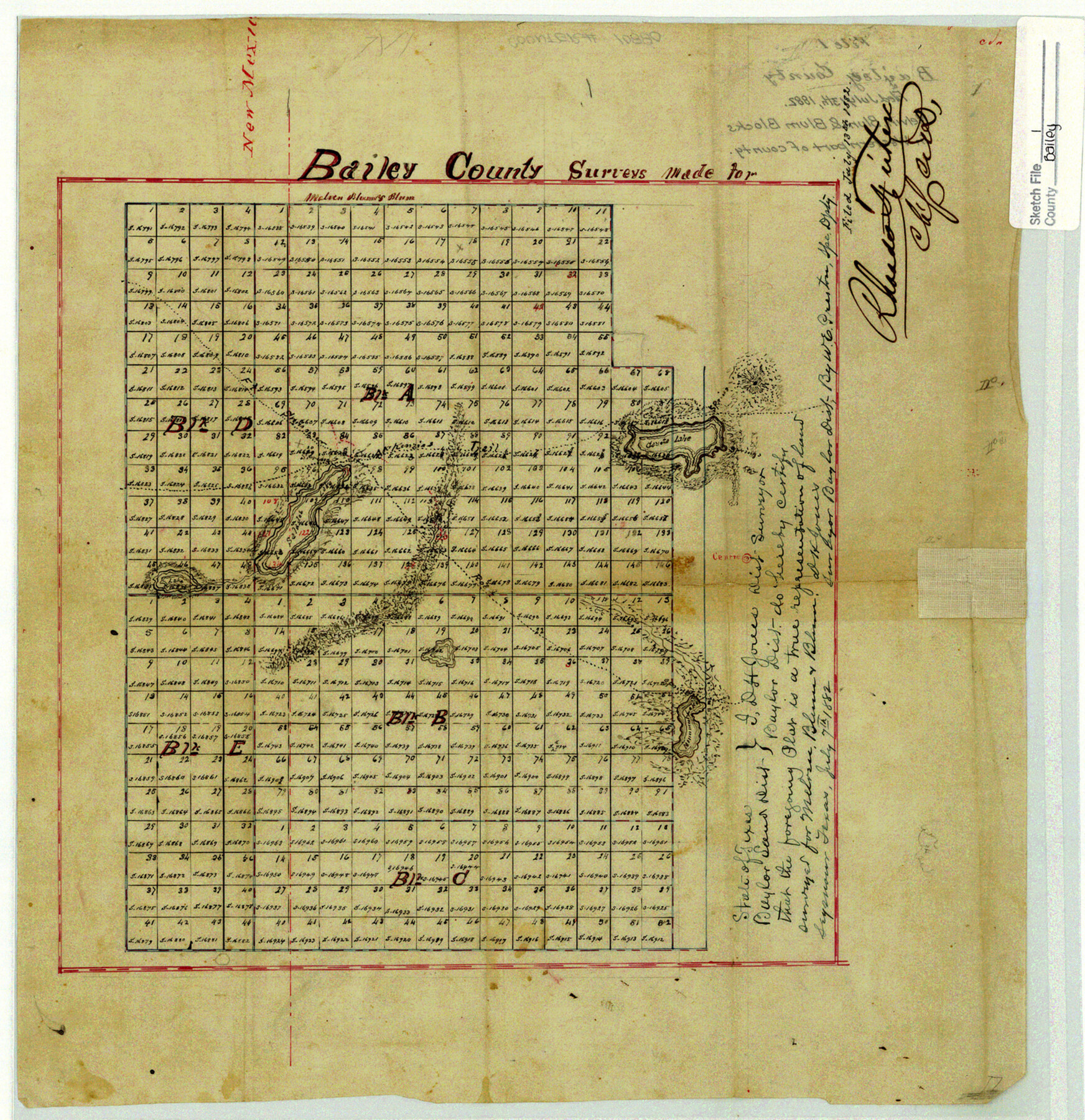
Bailey County Sketch File 1
[Sketch of Melvin & Blum Blocks A, B, C, D, and E in west part of county]
-
Map/Doc
10880
-
Collection
General Map Collection
-
Object Dates
1882/7/7 (Creation Date)
1882/7/13 (File Date)
-
People and Organizations
D. H. Jones (Surveyor/Engineer)
-
Counties
Bailey
-
Subjects
Surveying Sketch File
-
Height x Width
15.8 x 15.3 inches
40.1 x 38.9 cm
-
Medium
paper, manuscript
-
Features
Coyote Lake
McKenzie's Trail
Salados Lake
Part of: General Map Collection
Harris County Sketch File 30

Print $21.00
- Digital $50.00
Harris County Sketch File 30
Size 11.3 x 8.5 inches
Map/Doc 25416
Harris County State Real Property Sketch 1

Print $40.00
- Digital $50.00
Harris County State Real Property Sketch 1
1985
Size 42.7 x 41.6 inches
Map/Doc 61690
Johnson County Working Sketch 8

Print $20.00
- Digital $50.00
Johnson County Working Sketch 8
1952
Size 20.0 x 17.3 inches
Map/Doc 66621
Flight Mission No. BRE-2P, Frame 129, Nueces County

Print $20.00
- Digital $50.00
Flight Mission No. BRE-2P, Frame 129, Nueces County
1956
Size 18.6 x 22.7 inches
Map/Doc 86802
Flight Mission No. BRE-1P, Frame 138, Nueces County

Print $20.00
- Digital $50.00
Flight Mission No. BRE-1P, Frame 138, Nueces County
1956
Size 18.4 x 22.3 inches
Map/Doc 86698
Hutchinson County Rolled Sketch 44-14

Print $20.00
- Digital $50.00
Hutchinson County Rolled Sketch 44-14
2002
Size 24.0 x 36.0 inches
Map/Doc 77550
Outer Continental Shelf Leasing Maps (Texas Offshore Operations)

Print $20.00
- Digital $50.00
Outer Continental Shelf Leasing Maps (Texas Offshore Operations)
Size 13.5 x 14.2 inches
Map/Doc 75843
Briscoe County Sketch File O-1

Print $2.00
- Digital $50.00
Briscoe County Sketch File O-1
1935
Size 11.3 x 7.2 inches
Map/Doc 16425
Henderson County Working Sketch Graphic Index

Print $40.00
- Digital $50.00
Henderson County Working Sketch Graphic Index
1988
Size 37.1 x 64.7 inches
Map/Doc 76576
Hudspeth County Working Sketch 34

Print $40.00
- Digital $50.00
Hudspeth County Working Sketch 34
1977
Size 63.1 x 37.3 inches
Map/Doc 66319
Leon County Working Sketch 18

Print $20.00
- Digital $50.00
Leon County Working Sketch 18
1960
Size 43.2 x 36.8 inches
Map/Doc 70417
Dickens County Rolled Sketch J

Print $20.00
- Digital $50.00
Dickens County Rolled Sketch J
1904
Size 25.4 x 32.9 inches
Map/Doc 8781
You may also like
Parker County Boundary File 2

Print $8.00
- Digital $50.00
Parker County Boundary File 2
Size 11.2 x 8.8 inches
Map/Doc 57835
Kendall County Boundary File 3

Print $36.00
- Digital $50.00
Kendall County Boundary File 3
Size 9.4 x 37.5 inches
Map/Doc 55756
Starr County Rolled Sketch 46B

Print $20.00
- Digital $50.00
Starr County Rolled Sketch 46B
1986
Size 17.9 x 34.5 inches
Map/Doc 7838
Presidio County Sketch File 117

Print $26.00
- Digital $50.00
Presidio County Sketch File 117
1994
Size 14.3 x 8.8 inches
Map/Doc 34906
San Patricio County NRC Article 33.136 Sketch 9

Print $82.00
San Patricio County NRC Article 33.136 Sketch 9
2022
Map/Doc 97031
Connected Map of DeWitt's Colony compiled from the surveys of Byrd Lockhart

Print $40.00
- Digital $50.00
Connected Map of DeWitt's Colony compiled from the surveys of Byrd Lockhart
1831
Size 39.2 x 54.0 inches
Map/Doc 1942
Right of Way and Track Map, Texas & New Orleans R.R. Co. operated by the T. & N. O. R.R. Co., Dallas-Sabine Branch

Print $40.00
- Digital $50.00
Right of Way and Track Map, Texas & New Orleans R.R. Co. operated by the T. & N. O. R.R. Co., Dallas-Sabine Branch
1918
Size 24.6 x 56.9 inches
Map/Doc 64629
Survey of Block L, University Lands, El Paso County, Texas

Print $40.00
- Digital $50.00
Survey of Block L, University Lands, El Paso County, Texas
1971
Size 43.4 x 71.6 inches
Map/Doc 2440
Nueces County Working Sketch 1

Print $20.00
- Digital $50.00
Nueces County Working Sketch 1
1937
Size 27.9 x 28.5 inches
Map/Doc 71303
Palo Pinto County Boundary File 3

Print $58.00
- Digital $50.00
Palo Pinto County Boundary File 3
Size 14.3 x 8.7 inches
Map/Doc 57800
Harris County Boundary File 39 (16)

Print $6.00
- Digital $50.00
Harris County Boundary File 39 (16)
Size 10.0 x 8.0 inches
Map/Doc 54354
McMullen County Working Sketch 7

Print $20.00
- Digital $50.00
McMullen County Working Sketch 7
1926
Size 20.7 x 17.5 inches
Map/Doc 70708