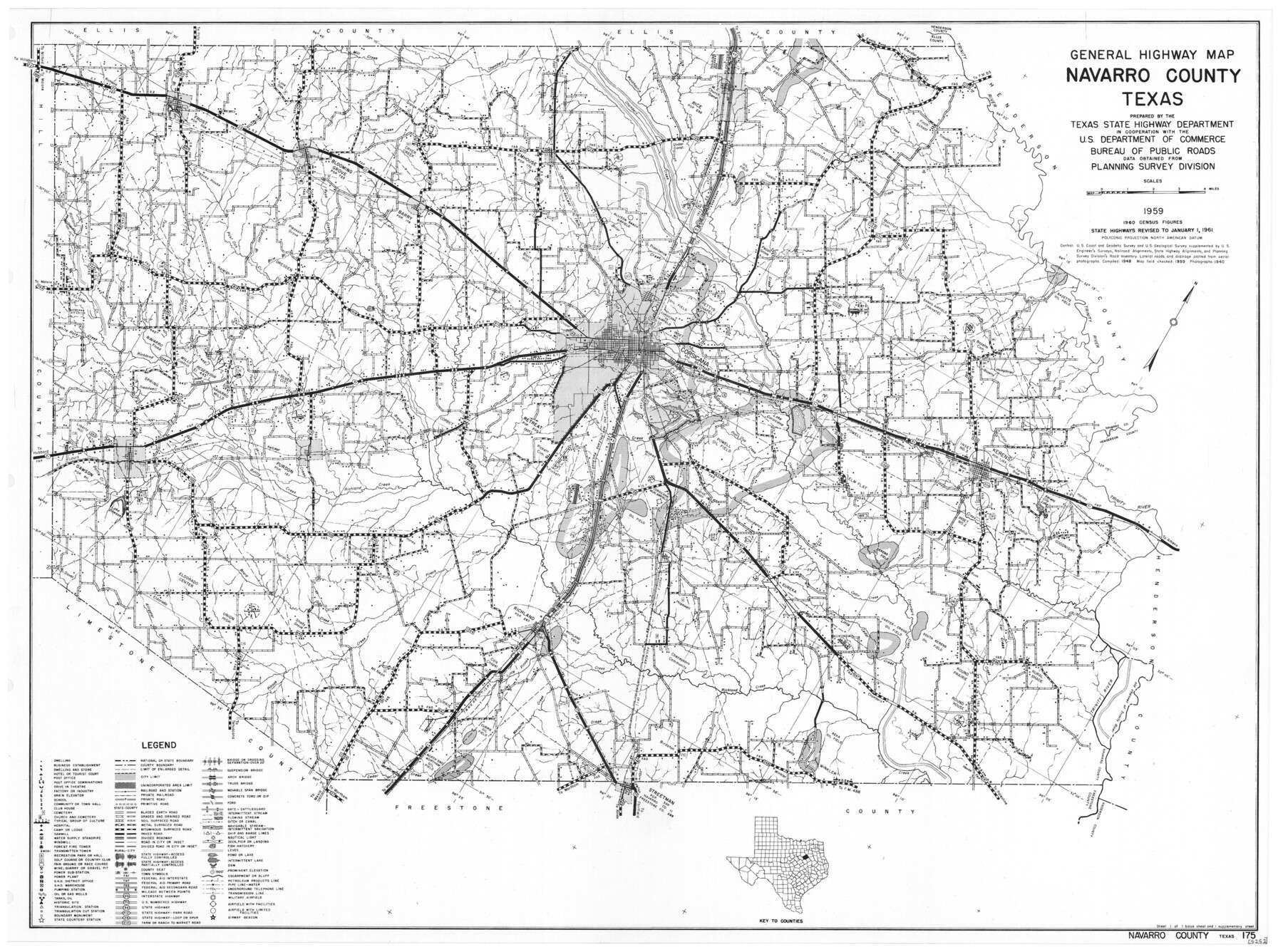
General Highway Map, Navarro County, Texas
-
Map/Doc
79610
-
Collection
Texas State Library and Archives
-
Object Dates
1961 (Creation Date)
-
People and Organizations
Texas State Highway Department (Publisher)
-
Counties
Navarro
-
Subjects
County
-
Height x Width
19.3 x 25.0 inches
49.0 x 63.5 cm
-
Comments
Prints available courtesy of the Texas State Library and Archives.
More info can be found here: TSLAC Map 05252
Part of: Texas State Library and Archives
Geological Petroleum Corporation Map of North Central Texas

Print $20.00
Geological Petroleum Corporation Map of North Central Texas
1920
Size 37.4 x 28.4 inches
Map/Doc 79305
General Highway Map, Palo Pinto County, Texas

Print $20.00
General Highway Map, Palo Pinto County, Texas
1940
Size 18.2 x 24.6 inches
Map/Doc 79213
General Highway Map, Bell County, Texas

Print $20.00
General Highway Map, Bell County, Texas
1940
Size 18.5 x 25.2 inches
Map/Doc 79015
General Highway Map, Hutchinson County, Texas

Print $20.00
General Highway Map, Hutchinson County, Texas
1961
Size 18.1 x 24.6 inches
Map/Doc 79529
General Highway Map, Bosque County, Texas

Print $20.00
General Highway Map, Bosque County, Texas
1940
Size 25.3 x 18.5 inches
Map/Doc 79022
General Highway Map, Kinney County, Uvalde County, Texas

Print $20.00
General Highway Map, Kinney County, Uvalde County, Texas
1940
Size 18.4 x 24.8 inches
Map/Doc 79162
General Highway Map. Detail of Cities and Towns in Angelina County, Texas [Lufkin and vicinity]
![79351, General Highway Map. Detail of Cities and Towns in Angelina County, Texas [Lufkin and vicinity], Texas State Library and Archives](https://historictexasmaps.com/wmedia_w700/maps/79351.tif.jpg)
Print $20.00
General Highway Map. Detail of Cities and Towns in Angelina County, Texas [Lufkin and vicinity]
1961
Size 18.3 x 25.0 inches
Map/Doc 79351
General Highway Map, Pecos County, Texas

Print $20.00
General Highway Map, Pecos County, Texas
1961
Size 24.6 x 18.2 inches
Map/Doc 79628
General Highway Map, Waller County, Texas

Print $20.00
General Highway Map, Waller County, Texas
1939
Size 25.1 x 18.5 inches
Map/Doc 79270
General Highway Map, Presidio County, Texas

Print $20.00
General Highway Map, Presidio County, Texas
1940
Size 24.6 x 18.3 inches
Map/Doc 79222
General Highway Map, Jasper County, Texas

Print $20.00
General Highway Map, Jasper County, Texas
1961
Size 18.3 x 24.7 inches
Map/Doc 79535
General Highway Map, Coryell County, Texas

Print $20.00
General Highway Map, Coryell County, Texas
1961
Size 18.1 x 24.8 inches
Map/Doc 79422
You may also like
Aransas County Sketch File 3

Print $4.00
- Digital $50.00
Aransas County Sketch File 3
Size 8.0 x 12.7 inches
Map/Doc 13104
United States - Gulf Coast - Padre I. and Laguna Madre Lat. 27° 12' to Lat. 26° 33' Texas

Print $20.00
- Digital $50.00
United States - Gulf Coast - Padre I. and Laguna Madre Lat. 27° 12' to Lat. 26° 33' Texas
1913
Size 27.0 x 18.3 inches
Map/Doc 72819
D. B. Gardner vs. Mrs. Clara C. Starr, Details 1, 2, 3, and 4

Print $20.00
- Digital $50.00
D. B. Gardner vs. Mrs. Clara C. Starr, Details 1, 2, 3, and 4
Size 25.1 x 30.0 inches
Map/Doc 91045
Hudspeth County Working Sketch 19

Print $20.00
- Digital $50.00
Hudspeth County Working Sketch 19
1959
Size 21.5 x 24.3 inches
Map/Doc 66301
Atascosa County Sketch File A

Print $40.00
- Digital $50.00
Atascosa County Sketch File A
Size 16.3 x 15.6 inches
Map/Doc 10869
El Paso County Working Sketch 52

Print $20.00
- Digital $50.00
El Paso County Working Sketch 52
1992
Size 29.1 x 16.1 inches
Map/Doc 69074
Crockett County, Texas

Print $20.00
- Digital $50.00
Crockett County, Texas
Size 28.8 x 21.4 inches
Map/Doc 90473
Flight Mission No. BQR-4K, Frame 67, Brazoria County

Print $20.00
- Digital $50.00
Flight Mission No. BQR-4K, Frame 67, Brazoria County
1952
Size 18.7 x 22.5 inches
Map/Doc 84000
Dimmit County Rolled Sketch 19

Print $20.00
- Digital $50.00
Dimmit County Rolled Sketch 19
1990
Size 45.4 x 41.7 inches
Map/Doc 8799
Hunt County Sketch File 19

Print $4.00
- Digital $50.00
Hunt County Sketch File 19
Size 8.2 x 10.1 inches
Map/Doc 27118
Flight Mission No. BQR-9K, Frame 8, Brazoria County

Print $20.00
- Digital $50.00
Flight Mission No. BQR-9K, Frame 8, Brazoria County
1952
Size 18.6 x 22.4 inches
Map/Doc 84037
Coryell County Boundary File 22

Print $60.00
- Digital $50.00
Coryell County Boundary File 22
Size 7.2 x 3.7 inches
Map/Doc 51932