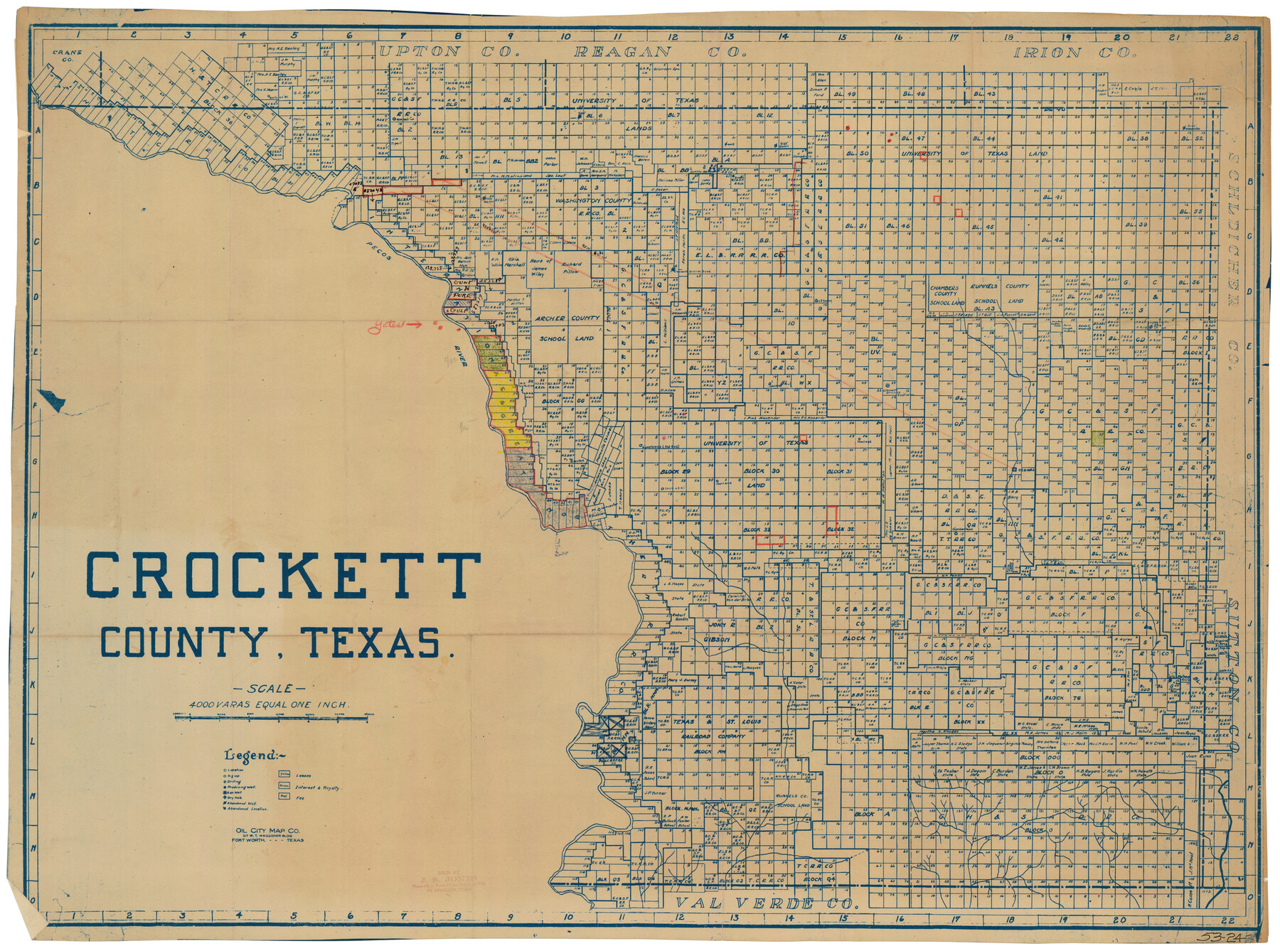
Crockett County, Texas
53-24
-
Map/Doc
90473
-
Collection
Twichell Survey Records
-
People and Organizations
Oil City Map Co. (Publisher)
-
Counties
Crockett
-
Subjects
County
-
Height x Width
28.8 x 21.4 inches
73.2 x 54.4 cm
Part of: Twichell Survey Records
[Blocks O, N, 34, B19, B29]
![92969, [Blocks O, N, 34, B19, B29], Twichell Survey Records](https://historictexasmaps.com/wmedia_w700/maps/92969-1.tif.jpg)
Print $20.00
- Digital $50.00
[Blocks O, N, 34, B19, B29]
Size 24.1 x 24.4 inches
Map/Doc 92969
[Portions of Blocks 20, 24, S, and the West Lone of Wilson County School Land]
![91326, [Portions of Blocks 20, 24, S, and the West Lone of Wilson County School Land], Twichell Survey Records](https://historictexasmaps.com/wmedia_w700/maps/91326-1.tif.jpg)
Print $20.00
- Digital $50.00
[Portions of Blocks 20, 24, S, and the West Lone of Wilson County School Land]
1910
Size 27.9 x 15.7 inches
Map/Doc 91326
[Sketch of J.D. Brown survey and vicinity]
![89965, [Sketch of J.D. Brown survey and vicinity], Twichell Survey Records](https://historictexasmaps.com/wmedia_w700/maps/89965-1.tif.jpg)
Print $40.00
- Digital $50.00
[Sketch of J.D. Brown survey and vicinity]
Size 43.5 x 63.0 inches
Map/Doc 89965

Map of the CB Live Stock Co. -N- Ranch situated in Crosby County, Texas

Print $20.00
- Digital $50.00
Map of the CB Live Stock Co. -N- Ranch situated in Crosby County, Texas
1907
Size 41.4 x 38.0 inches
Map/Doc 89919
Amended Plat New Hobbs Addition to New Hobbs, Lea County, New Mexico

Print $20.00
- Digital $50.00
Amended Plat New Hobbs Addition to New Hobbs, Lea County, New Mexico
Size 24.1 x 18.5 inches
Map/Doc 92418
Lubbock County Sketch

Print $20.00
- Digital $50.00
Lubbock County Sketch
1945
Size 18.3 x 29.6 inches
Map/Doc 92829
[Sketch showing H. T. & B. section 126 and B. H. Epperson]
![90932, [Sketch showing H. T. & B. section 126 and B. H. Epperson], Twichell Survey Records](https://historictexasmaps.com/wmedia_w700/maps/90932-1.tif.jpg)
Print $20.00
- Digital $50.00
[Sketch showing H. T. & B. section 126 and B. H. Epperson]
Size 23.9 x 32.5 inches
Map/Doc 90932
[Wm. Baker and Chas. Lydings surveys and vicinity]
![92988, [Wm. Baker and Chas. Lydings surveys and vicinity], Twichell Survey Records](https://historictexasmaps.com/wmedia_w700/maps/92988-1.tif.jpg)
Print $2.00
- Digital $50.00
[Wm. Baker and Chas. Lydings surveys and vicinity]
Size 6.6 x 7.0 inches
Map/Doc 92988
Working Sketch Compiled from Original Field Showing Surveys in Irion County Located by J. A. McDonald in 1856 and 1858

Print $20.00
- Digital $50.00
Working Sketch Compiled from Original Field Showing Surveys in Irion County Located by J. A. McDonald in 1856 and 1858
Size 13.1 x 13.8 inches
Map/Doc 92191
Subdivision Map of Childress County School Land Situated in Bailey and Cochran Counties, Texas

Print $20.00
- Digital $50.00
Subdivision Map of Childress County School Land Situated in Bailey and Cochran Counties, Texas
Size 23.0 x 26.4 inches
Map/Doc 92526
[Northwest part of the County]
![90841, [Northwest part of the County], Twichell Survey Records](https://historictexasmaps.com/wmedia_w700/maps/90841-2.tif.jpg)
Print $20.00
- Digital $50.00
[Northwest part of the County]
Size 17.9 x 34.9 inches
Map/Doc 90841
You may also like
El Paso County Rolled Sketch 53

Print $105.00
- Digital $50.00
El Paso County Rolled Sketch 53
1930
Size 10.1 x 15.3 inches
Map/Doc 44486
Leon County Working Sketch 58

Print $20.00
- Digital $50.00
Leon County Working Sketch 58
1986
Size 27.7 x 43.3 inches
Map/Doc 70458
Cass County Sketch File 5 and 5a

Print $6.00
- Digital $50.00
Cass County Sketch File 5 and 5a
1851
Size 2.8 x 5.1 inches
Map/Doc 17401
Fractional Township No. 8 South Range No. 22 East of the Indian Meridian, Indian Territory

Print $20.00
- Digital $50.00
Fractional Township No. 8 South Range No. 22 East of the Indian Meridian, Indian Territory
1897
Size 19.2 x 24.2 inches
Map/Doc 75239
Crockett County Working Sketch 93

Print $40.00
- Digital $50.00
Crockett County Working Sketch 93
1979
Size 43.5 x 65.4 inches
Map/Doc 68426
Tom Green County Sketch File 51

Print $20.00
- Digital $50.00
Tom Green County Sketch File 51
1884
Size 44.0 x 27.5 inches
Map/Doc 10403
[Rockwall County School Land and adjacent Blocks]
![90758, [Rockwall County School Land and adjacent Blocks], Twichell Survey Records](https://historictexasmaps.com/wmedia_w700/maps/90758-1.tif.jpg)
Print $20.00
- Digital $50.00
[Rockwall County School Land and adjacent Blocks]
1904
Size 17.5 x 23.2 inches
Map/Doc 90758
Map of Comal County, Texas

Print $20.00
- Digital $50.00
Map of Comal County, Texas
1879
Size 23.4 x 28.6 inches
Map/Doc 701
Flight Mission No. CRC-3R, Frame 48, Chambers County

Print $20.00
- Digital $50.00
Flight Mission No. CRC-3R, Frame 48, Chambers County
1956
Size 18.7 x 22.4 inches
Map/Doc 84821
Crockett County Sketch File 29

Print $8.00
- Digital $50.00
Crockett County Sketch File 29
1883
Size 12.5 x 8.1 inches
Map/Doc 19727
Hunt County Sketch File 43

Print $6.00
- Digital $50.00
Hunt County Sketch File 43
1851
Size 8.4 x 13.0 inches
Map/Doc 27165
General Highway Map, Houston County, Texas

Print $20.00
General Highway Map, Houston County, Texas
1961
Size 24.7 x 18.2 inches
Map/Doc 79525