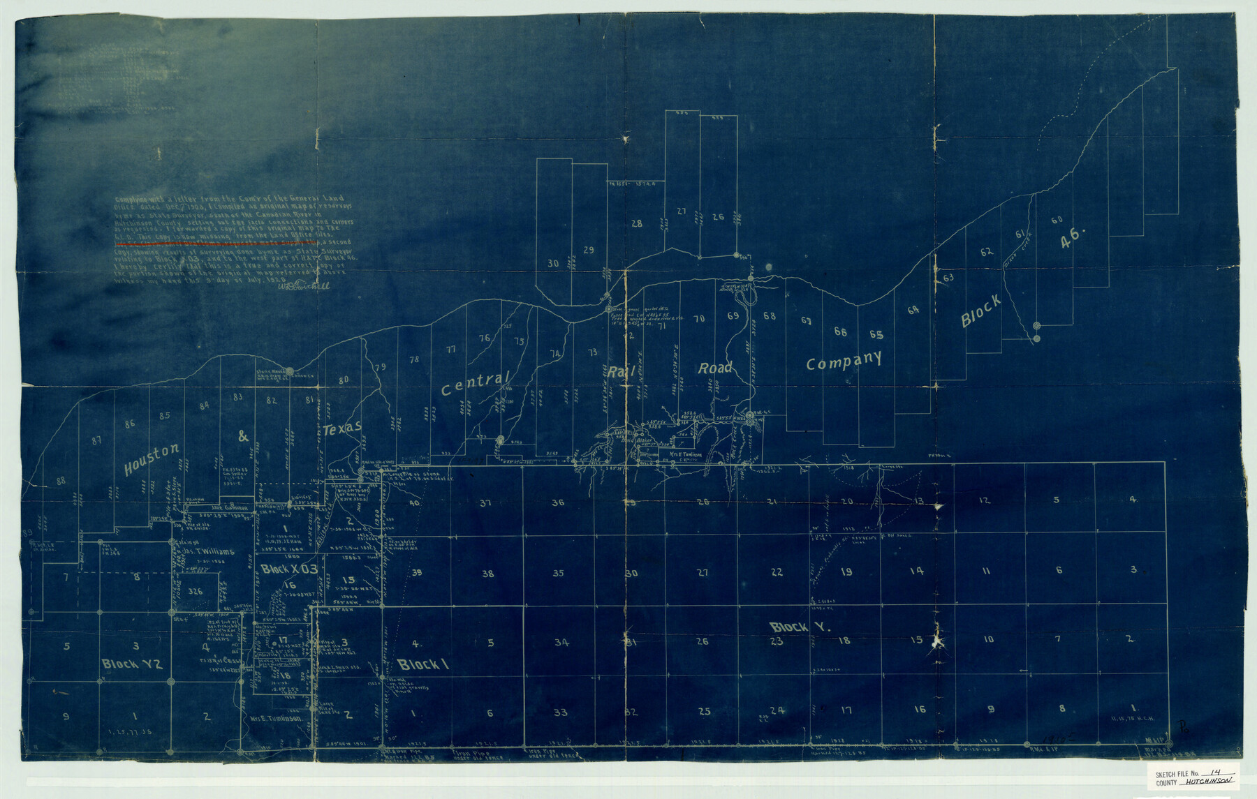
Hutchinson County Sketch File 14
South of Canadian River
-
Map/Doc
11812
-
Collection
General Map Collection
-
Object Dates
7/9/1920 (Creation Date)
-
People and Organizations
W.D. Twichell (Surveyor/Engineer)
-
Counties
Hutchinson
-
Subjects
Surveying Sketch File
-
Height x Width
21.5 x 33.8 inches
54.6 x 85.9 cm
-
Medium
blueprint/diazo
-
Features
Dixon Creek
Canadian River
Antilope [sic] Creek
Plemons Panhandle Road
Part of: General Map Collection

Polk County Sketch File 31

Print $10.00
- Digital $50.00
Polk County Sketch File 31
Size 14.2 x 8.6 inches
Map/Doc 34221
Terrell County Working Sketch 53

Print $20.00
- Digital $50.00
Terrell County Working Sketch 53
Size 13.5 x 17.8 inches
Map/Doc 69802
Baylor County Sketch File 14

Print $4.00
- Digital $50.00
Baylor County Sketch File 14
1879
Size 13.0 x 8.2 inches
Map/Doc 14181
Starr County Working Sketch 18

Print $20.00
- Digital $50.00
Starr County Working Sketch 18
1982
Size 29.5 x 34.3 inches
Map/Doc 63934
Jack County Sketch File 15a

Print $6.00
- Digital $50.00
Jack County Sketch File 15a
1875
Size 14.7 x 10.2 inches
Map/Doc 27547
Live Oak County Boundary File 60

Print $12.00
- Digital $50.00
Live Oak County Boundary File 60
Size 8.8 x 7.6 inches
Map/Doc 56401
Brazoria County

Print $20.00
- Digital $50.00
Brazoria County
1873
Size 26.7 x 26.1 inches
Map/Doc 858
Flight Mission No. CGI-1N, Frame 134, Cameron County

Print $20.00
- Digital $50.00
Flight Mission No. CGI-1N, Frame 134, Cameron County
1955
Size 18.5 x 22.1 inches
Map/Doc 84490
Maverick County Working Sketch 14

Print $20.00
- Digital $50.00
Maverick County Working Sketch 14
1970
Size 41.2 x 42.6 inches
Map/Doc 70906
Duval County Rolled Sketch 29

Print $20.00
- Digital $50.00
Duval County Rolled Sketch 29
1947
Size 16.2 x 25.8 inches
Map/Doc 5746
Webb County Working Sketch 23

Print $20.00
- Digital $50.00
Webb County Working Sketch 23
1927
Size 15.1 x 17.3 inches
Map/Doc 72388
You may also like
General Highway Map, DeWitt County, Texas

Print $20.00
General Highway Map, DeWitt County, Texas
1961
Size 18.3 x 24.5 inches
Map/Doc 79442
Subdivision of the J. F. Carter Estate

Print $3.00
- Digital $50.00
Subdivision of the J. F. Carter Estate
Size 11.8 x 9.6 inches
Map/Doc 91273
Nueces County Working Sketch 7

Print $40.00
- Digital $50.00
Nueces County Working Sketch 7
1972
Size 26.9 x 72.6 inches
Map/Doc 71309
El Paso County Working Sketch 2

Print $20.00
- Digital $50.00
El Paso County Working Sketch 2
1913
Size 15.5 x 25.0 inches
Map/Doc 69024
Boundary and Ownership map, Laguna Atascosa National Wildlife Refuge, Cameron and Willacy Counties, Texas

Print $40.00
- Digital $50.00
Boundary and Ownership map, Laguna Atascosa National Wildlife Refuge, Cameron and Willacy Counties, Texas
1968
Size 73.9 x 43.2 inches
Map/Doc 60395
Zavala County Rolled Sketch 33

Print $20.00
- Digital $50.00
Zavala County Rolled Sketch 33
Size 19.3 x 26.9 inches
Map/Doc 8334
Flight Mission No. DQN-1K, Frame 140, Calhoun County

Print $20.00
- Digital $50.00
Flight Mission No. DQN-1K, Frame 140, Calhoun County
1953
Size 18.5 x 22.2 inches
Map/Doc 84203
Map of the Country Upon the Brazos and Big Wichita Rivers Embracing the Lands appropriated by the State of Texas for the Use of the Indians

Print $20.00
Map of the Country Upon the Brazos and Big Wichita Rivers Embracing the Lands appropriated by the State of Texas for the Use of the Indians
1854
Size 28.8 x 32.3 inches
Map/Doc 76284
Flight Mission No. CGN-3P, Frame 142, San Patricio County

Print $20.00
- Digital $50.00
Flight Mission No. CGN-3P, Frame 142, San Patricio County
1956
Size 18.5 x 22.1 inches
Map/Doc 86986
Kinney County Sketch File 16a

Print $40.00
- Digital $50.00
Kinney County Sketch File 16a
Size 12.8 x 16.0 inches
Map/Doc 29133
Johnson County State of Texas

Print $20.00
- Digital $50.00
Johnson County State of Texas
1888
Size 30.2 x 35.3 inches
Map/Doc 3733
[Surveys along the Red River]
![5, [Surveys along the Red River], General Map Collection](https://historictexasmaps.com/wmedia_w700/maps/5.tif.jpg)
Print $2.00
- Digital $50.00
[Surveys along the Red River]
Size 14.1 x 5.6 inches
Map/Doc 5