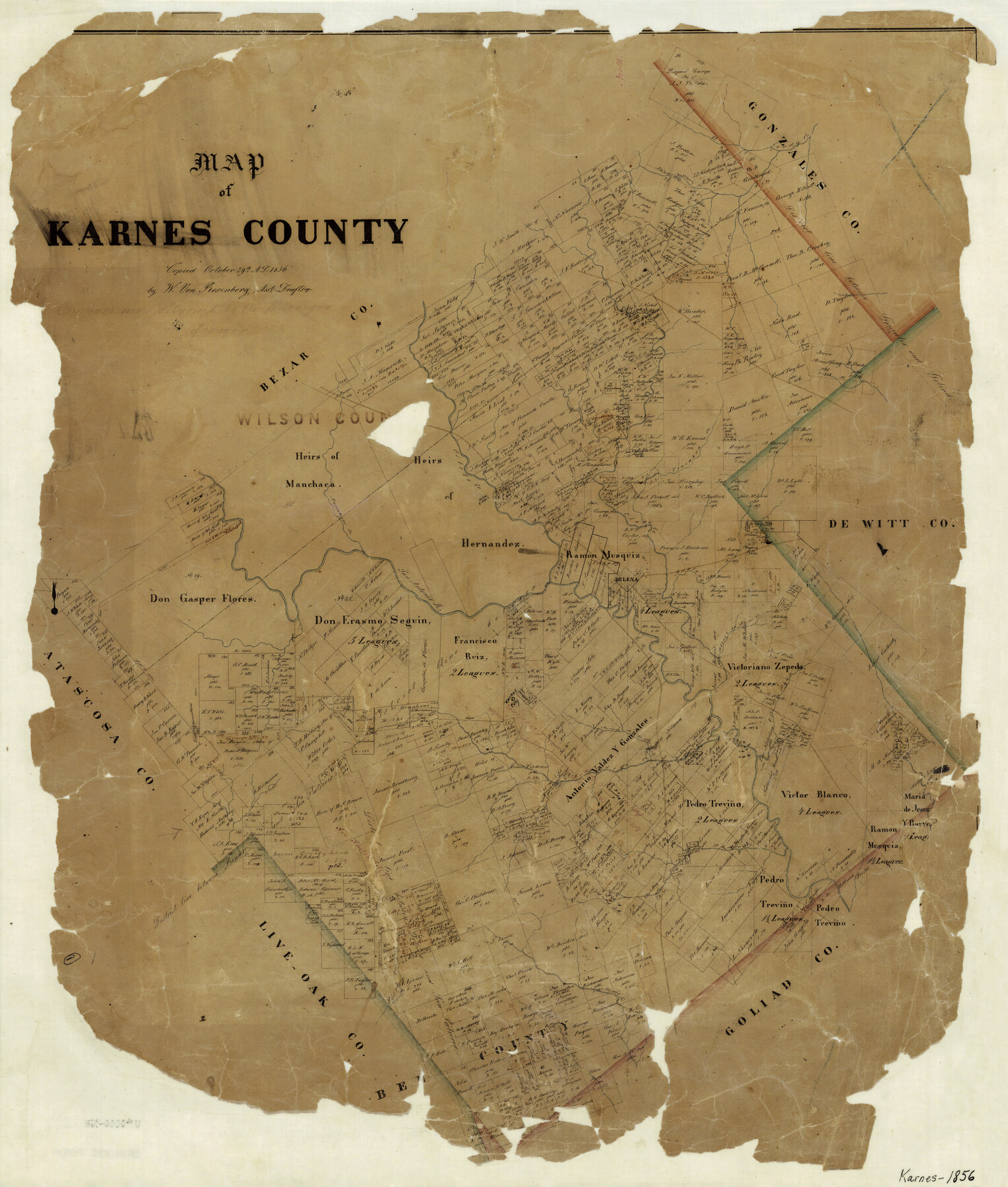
Map of Karnes County
-
Map/Doc
3745
-
Collection
General Map Collection
-
Object Dates
10/29/1856 (Creation Date)
-
People and Organizations
W. von Rosenberg (Draftsman)
-
Counties
Karnes
-
Subjects
County
-
Height x Width
26.2 x 22.4 inches
66.6 x 56.9 cm
-
Comments
Copied October 29, 1856.
-
Features
Ojo de Agua
Olmos Creek
Salt Creek
Rhimes Creek
Karnes City
Pedro Creek
Medio Creek
Hondo Creek
Tordillio Mountain
Arroyo de la Parito
Escondido Creek
Sandy Creek
Fall Creek
Alonzo Creek
Helena
San Antonio River
Marcelinas Creek
Cibolo Creek
Cleto Creek
Toncahua Creek
Elm Creek
Mustang Creek
Part of: General Map Collection
Borden County Working Sketch 11

Print $40.00
- Digital $50.00
Borden County Working Sketch 11
1955
Size 51.6 x 26.5 inches
Map/Doc 67471
Val Verde County Working Sketch 8

Print $20.00
- Digital $50.00
Val Verde County Working Sketch 8
1917
Size 31.4 x 32.0 inches
Map/Doc 72143
Leon County Working Sketch 28

Print $20.00
- Digital $50.00
Leon County Working Sketch 28
1971
Size 25.0 x 30.1 inches
Map/Doc 70427
Real County Rolled Sketch 9

Print $20.00
- Digital $50.00
Real County Rolled Sketch 9
1967
Size 33.4 x 40.6 inches
Map/Doc 9834

Map of Cherokee County

Print $20.00
- Digital $50.00
Map of Cherokee County
1877
Size 29.0 x 21.2 inches
Map/Doc 3389
Flight Mission No. DAG-18K, Frame 77, Matagorda County

Print $20.00
- Digital $50.00
Flight Mission No. DAG-18K, Frame 77, Matagorda County
1952
Size 18.5 x 22.3 inches
Map/Doc 86370
Fayette County Sketch File 6

Print $114.00
- Digital $50.00
Fayette County Sketch File 6
1981
Size 14.9 x 9.5 inches
Map/Doc 22508

Maverick County Rolled Sketch 18

Print $20.00
- Digital $50.00
Maverick County Rolled Sketch 18
1946
Size 35.6 x 21.5 inches
Map/Doc 6711
Harris County NRC Article 33.136 Sketch 15

Print $28.00
- Digital $50.00
Harris County NRC Article 33.136 Sketch 15
2012
Size 24.0 x 18.0 inches
Map/Doc 94762
Map of The Surveyed Part of Peters Colony Texas

Print $40.00
- Digital $50.00
Map of The Surveyed Part of Peters Colony Texas
1854
Size 53.1 x 33.9 inches
Map/Doc 83008
You may also like
Wilbarger County Sketch File 12

Print $8.00
- Digital $50.00
Wilbarger County Sketch File 12
Size 12.7 x 8.1 inches
Map/Doc 40185
Walker County Working Sketch 1

Print $20.00
- Digital $50.00
Walker County Working Sketch 1
1912
Size 20.1 x 18.4 inches
Map/Doc 72281
Briscoe County

Print $20.00
- Digital $50.00
Briscoe County
1930
Size 46.2 x 39.2 inches
Map/Doc 1787
Coryell County Working Sketch 19

Print $20.00
- Digital $50.00
Coryell County Working Sketch 19
1970
Size 38.7 x 33.2 inches
Map/Doc 68226
Taylor County Sketch File 3

Print $4.00
- Digital $50.00
Taylor County Sketch File 3
Size 7.5 x 8.3 inches
Map/Doc 37778
Pecos County Rolled Sketch 158

Print $20.00
- Digital $50.00
Pecos County Rolled Sketch 158
1961
Size 21.9 x 27.4 inches
Map/Doc 7284
[Sketch showing Runnels County School Land survey and surrounding surveys]
![93112, [Sketch showing Runnels County School Land survey and surrounding surveys], Twichell Survey Records](https://historictexasmaps.com/wmedia_w700/maps/93112-1.tif.jpg)
Print $20.00
- Digital $50.00
[Sketch showing Runnels County School Land survey and surrounding surveys]
Size 21.4 x 14.3 inches
Map/Doc 93112
[Sketch for Mineral Application 17237 / Mineral File 11855 - Neches River, Joe A. Sanders]
![2819, [Sketch for Mineral Application 17237 / Mineral File 11855 - Neches River, Joe A. Sanders], General Map Collection](https://historictexasmaps.com/wmedia_w700/maps/2819.tif.jpg)
Print $2.00
- Digital $50.00
[Sketch for Mineral Application 17237 / Mineral File 11855 - Neches River, Joe A. Sanders]
1927
Size 12.8 x 8.2 inches
Map/Doc 2819
Sulphur River and Cuthand Creek, Hardison Lake Sheet

Print $20.00
- Digital $50.00
Sulphur River and Cuthand Creek, Hardison Lake Sheet
1919
Size 13.4 x 18.0 inches
Map/Doc 78327
Jefferson County NRC Article 33.136 Location Key Sheet

Print $20.00
- Digital $50.00
Jefferson County NRC Article 33.136 Location Key Sheet
1974
Size 27.0 x 23.0 inches
Map/Doc 77029
Van Zandt County Rolled Sketch 6

Print $6.00
- Digital $50.00
Van Zandt County Rolled Sketch 6
1946
Size 33.5 x 34.2 inches
Map/Doc 10091
Midland County Rolled Sketch 12

Print $40.00
- Digital $50.00
Midland County Rolled Sketch 12
Size 97.0 x 42.6 inches
Map/Doc 9520