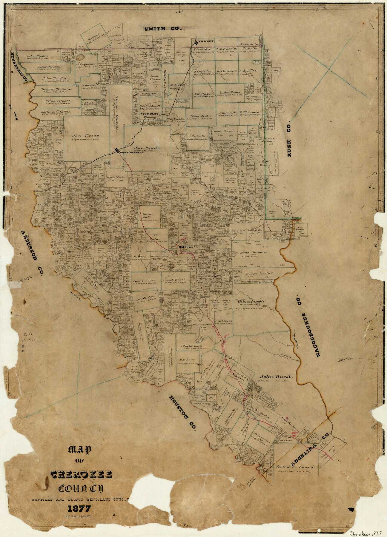
Map of Cherokee County
-
Map/Doc
3389
-
Collection
General Map Collection
-
Object Dates
1877 (Creation Date)
-
People and Organizations
F.H. Arlitt (Draftsman)
-
Counties
Cherokee
-
Subjects
County
-
Height x Width
29.0 x 21.2 inches
73.7 x 53.9 cm
-
Features
Troupe
Reynolds
I&GN
Jacksonville
Mud Creek
Neches River
Striker Creek
Rusk
SL&S
Alto
Angelina River
Roarks Creek
Comer
Larrison's [sic] Creek
Wells
Former
Part of: General Map Collection
Flight Mission No. DAG-24K, Frame 152, Matagorda County

Print $20.00
- Digital $50.00
Flight Mission No. DAG-24K, Frame 152, Matagorda County
1953
Size 18.4 x 22.3 inches
Map/Doc 86566
Liberty County Sketch File 25

Print $8.00
- Digital $50.00
Liberty County Sketch File 25
1861
Size 8.0 x 10.0 inches
Map/Doc 29939
Township 10 North Range 15 West, North Western District, Louisiana

Print $20.00
- Digital $50.00
Township 10 North Range 15 West, North Western District, Louisiana
1854
Size 19.5 x 24.6 inches
Map/Doc 65871
United States, 1956 Revised Edition

Print $20.00
- Digital $50.00
United States, 1956 Revised Edition
1946
Size 47.9 x 35.9 inches
Map/Doc 78630
Harris County NRC Article 33.136 Sketch 13

Print $28.00
- Digital $50.00
Harris County NRC Article 33.136 Sketch 13
2009
Size 36.0 x 24.3 inches
Map/Doc 94641
Flight Mission No. CRC-2R, Frame 132, Chambers County

Print $20.00
- Digital $50.00
Flight Mission No. CRC-2R, Frame 132, Chambers County
1956
Size 18.6 x 22.3 inches
Map/Doc 84748
Briscoe County Sketch File 5

Print $40.00
- Digital $50.00
Briscoe County Sketch File 5
Size 29.8 x 26.5 inches
Map/Doc 10994
Wichita County Rolled Sketch 5

Print $20.00
- Digital $50.00
Wichita County Rolled Sketch 5
Size 24.1 x 39.2 inches
Map/Doc 8242
Map of Sabine County

Print $20.00
- Digital $50.00
Map of Sabine County
1896
Size 25.8 x 17.9 inches
Map/Doc 63012
Morris County Rolled Sketch 2A

Print $20.00
- Digital $50.00
Morris County Rolled Sketch 2A
Size 24.0 x 18.7 inches
Map/Doc 10234

Floyd County Boundary File 2b

Print $40.00
- Digital $50.00
Floyd County Boundary File 2b
Size 38.9 x 20.1 inches
Map/Doc 53490
You may also like
Freestone County Boundary File 30a

Print $10.00
- Digital $50.00
Freestone County Boundary File 30a
Size 14.1 x 8.8 inches
Map/Doc 53592
Flight Mission No. BRA-6M, Frame 83, Jefferson County

Print $20.00
- Digital $50.00
Flight Mission No. BRA-6M, Frame 83, Jefferson County
1953
Size 18.6 x 22.3 inches
Map/Doc 85427
Edwards County Working Sketch 121

Print $20.00
- Digital $50.00
Edwards County Working Sketch 121
1976
Size 28.2 x 24.8 inches
Map/Doc 68997

North Line Garza County/South Line Crosby County

Print $20.00
- Digital $50.00
North Line Garza County/South Line Crosby County
1887
Size 8.3 x 35.1 inches
Map/Doc 90904
Jefferson County Working Sketch 5

Print $20.00
- Digital $50.00
Jefferson County Working Sketch 5
1930
Size 32.7 x 21.8 inches
Map/Doc 66548
PSL Field Notes for Blocks A42 through A55 in Andrews County

PSL Field Notes for Blocks A42 through A55 in Andrews County
Map/Doc 81644
La Salle County Working Sketch 34

Print $20.00
- Digital $50.00
La Salle County Working Sketch 34
1956
Size 18.8 x 26.2 inches
Map/Doc 70335
Haskell County Working Sketch 6

Print $20.00
- Digital $50.00
Haskell County Working Sketch 6
1949
Size 18.9 x 16.4 inches
Map/Doc 66064
Coryell County Working Sketch 22

Print $20.00
- Digital $50.00
Coryell County Working Sketch 22
1976
Size 24.9 x 35.3 inches
Map/Doc 68229
Haskell County Rolled Sketch 12
Print $40.00
- Digital $50.00
Haskell County Rolled Sketch 12
Size 56.7 x 36.1 inches
Map/Doc 9147
Bee County Sketch File 5

Print $40.00
- Digital $50.00
Bee County Sketch File 5
Size 27.4 x 23.4 inches
Map/Doc 10914